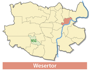
Wesertor (Kassel)
|
Wesertor district of Kassel |
||
|---|---|---|
| Coordinates | 51 ° 19 '24 " N , 9 ° 30' 47" E | |
| surface | 1.55 km² (22/23) | |
| Residents | 10,303 (Dec. 31, 2019) (9/23) | |
| Population density | 6647 inhabitants / km² (2/23) | |
| Proportion of foreigners | 37.8% (Dec. 31, 2019) (3/23) | |
| Post Code | 34125 | |
| prefix | 0561 | |
| Website | Kassel-Wesertor | |
| politics | ||
| Head of town | Ingeborg Jordan ( SPD ) | |
| Allocation of seats (local advisory board) | ||
|
||
| Source: Kassel Statistical Atlas | ||
Wesertor is one of 23 districts of the north Hessian city of Kassel ( Hesse , Germany ).
geography
location
The Wesertor district is bounded to the southeast by the Fulda and to the north by the ridge of the Möncheberg. In the area of the horse market and on Schützenstraße, the Ahna flows from the Habichtswald to the mouth just above the harbor bridge.
history
Historically, the Weser Gate was the part of the city that joined the Fulda lowlands outside the Weser Gate to the northeast of the old town. The Ahnaberg monastery originally stood in the area of the Finkenherd, which played a decisive role in the history of the town.
Wesertor is an old working-class district with a high mix but since the 1990s with a continuous loss of owner-managed supply structure.
Site and buildings
Large parts of the Weser Gate were destroyed by the Second World War . Only a few testimonies tell of its historical past, such as the armory and the Karlshospital . Both buildings were in ruins until the 2000s and have been renovated. The armory, of which only the outer walls of the head building on Artilleriestrasse / Zeughausstrasse have been preserved, was supplemented by the installation of a cafeteria for the adjacent vocational schools. The historical substance of the Karlshospital was completely gutted and built over.
The neighboring Vogt'sche Mühle has been in operation as a hydropower plant for the use of the barrage in the Kassel city center for over 800 years.
In the direction of Wolfsanger, there are wholesale markets (food, furniture).
There are several churches in the district , including the Brethren Church and the parish church of St. Bonifatius, built in 1957 . Small town squares characterize the quarters on Gartenstrasse and Sodensternstrasse, as well as above the Goetheschule on Ysenburgstrasse.
There are green spaces along the banks of the sewage treatment plant and the port area, and between Schützenstraße and Fulda / Ahna in the area of the island of Finkenherd . This is where the common residents' gardens and gardens used to be.
traffic
The main roads are Weserstraße ( B 3 ), which splits into Fuldatalstraße and Ihringshäuser Straße at Weserspitze, and Kurt-Wolters-Straße / Schützenstraße ( B 7 / B 83 ) with the harbor bridge over the Fulda to the “Kleiner Kreisel” ". There are tram routes in Weser-, Fuldatal- and Ihringshäuser Straße as well as in the middle ring.
Neighboring districts
To the northeast, the Wesertor district is bounded by Wolfsanger and Fasanenhof . North Holland borders in the north and Wesertor in the west Mitte . In the south-east is the Untereustadt district .


