
Front west
|
district of Kassel |
||
|---|---|---|
 |
||
| Coordinates | 51 ° 18 ′ 55 " N , 9 ° 28 ′ 17" E | |
| height | 180 m above sea level NHN | |
| surface | 1.92 km² (19/23) | |
| Residents | 15,922 (Dec. 31, 2019) (2/23) | |
| Population density | 8293 inhabitants / km² (1/23) | |
| Proportion of foreigners | 9.1% (Dec. 31, 2019) (18/23) | |
| Post Code | 34119 | |
| prefix | 0561 | |
| Website | District info west | |
| politics | ||
| Mayor | Steffen Müller ( Alliance 90 / The Greens ) | |
| Allocation of seats (local advisory board) | ||
 |
||
| Source: Kassel Statistical Atlas | ||
The Vordere Westen (officially West until May 9, 2010 ) is a district of the north Hessian city of Kassel . It is characterized by a dense Wilhelminian style development that goes back to the Kassel industrialist Sigmund Aschrott .
geography
The Vorderer Westen district is located west of Kassel's city center . It borders the districts of Rothenditmold (in the north), Mitte (northeast, east and southeast), Wehlheiden (south), Bad Wilhelmshöhe (southwest) and Kirchditmold (northwest).
The front west is bounded in the west, northwest and north by railway tracks leading from Kassel-Wilhelmshöhe station to Kassel main station , in the east by the axis of the side streets Hardenberg, Westend and Sophienstrasse and in the south by sections of the west-east direction from Bergpark Wilhelmshöhe to Wilhelmshöher Allee leading to Kassel's city center .
Local council election
The turnout in the 2016 local council election was 51.81%.
Transport links and the townscape
The district of Vorderer Westen is easy to reach via the side streets that branch off from Wilhelmshöher Allee to the north. Other main roads are Friedrich-Ebert-Straße , which also runs in a west-east direction, and the Breitscheidstraße – Kölnische Straße axis, which lead to the city center.

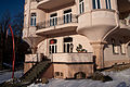
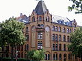
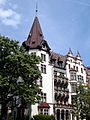
On Friedrich-Ebert-Straße running through the middle of the Vorderen West are the Bebelplatz and the Kassel town hall with the parks “Stadthallengarten” and “Rosengarten”. In the north, the elongated pine grove spreads out, in which the Kassel-Tannenwäldchen transmitter is located and on the eastern edge of which is the Kassel Youth Hostel . Especially in the area of the Bebelplatz there are numerous Art Nouveau , Heimatstil and Historicism buildings that survived the Second World War , in which Kassel was hit by many bombings. In the western area of the district there is the small Aschrottpark , a little to the southwest of it is the building of the Federal Social Court and a little to the southeast of it is the Goetheanlage .

Goethestern

At the Goethestern
At the Goethestern
Goethestrasse
Goethestrasse

Goethestrasse

Herkulesstrasse

Crossing Herkulesstraße / Pestalozzistraße

Crossing Herkulesstraße / Pestalozzistraße

Pestalozzistrasse

Wilhelmshöher Allee
Wilhelmshöher Allee


.jpg)
.jpg)


.jpg)


Web links
Bad Wilhelmshöhe | Bettenhausen | Brasselsberg | Fasanenhof | Forstfeld | Harleshausen | Maiden head | Kirchditmold | Middle | Niederzwehren | North Holland | Nordshausen | Oberzwehren | Philippinenhof-Warteberg | Rothenditmold | Südstadt | Süsterfeld-Helleböhn | Untereustadt | Front West | Waldau | Wehlheiden | Wesertor | Wolfsanger / hare hedge