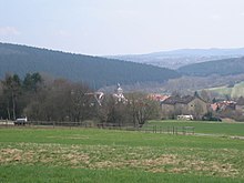
Eschenstruth
|
Eschenstruth
Helsa municipality
Coordinates: 51 ° 13 ′ 40 ″ N , 9 ° 39 ′ 46 ″ E
|
|
|---|---|
| Height : | 347 (310-380) m above sea level NHN |
| Area : | 8.09 km² |
| Residents : | 1800 approx. |
| Population density : | 222 inhabitants / km² |
| Incorporation : | August 1, 1972 |
| Postal code : | 34298 |
| Area code : | 05602 |


Eschenstruth is one of a total of four districts of the municipality of Helsa in the northern Hessian district of Kassel . It has about 1800 inhabitants.
geography
Eschenstruth is located on the eastern flank of the wooded Söhre (sub-area Stiftswald Kaufungen ) southeast below the Kleiner Belgerkopf (approx. 490 m above sea level ). The village is about 3.6 km (as the crow flies ) south-south-west of the Helsinki core town. In a roughly west-east direction, the Männerwasser flows south past the village and flows into the Losse east below the village ; directly across the river is the Kaufunger Wald . The village is between 310 and 380 m above sea level. NN .
In Lossetal extends between Helsa and the southeast, Hessian light Auer village Fürstenhagen the Federal Highway 7 , from which the by Eschenstruth southwest to St. Ottilie leading national road 3460 branches, and also runs along the Losse the railway Kassel-Waldkappel ( Losse Talbahn ) on which today the RegioTram runs, with a stop in Eschenstruth.
About 2.5 km north of Eschenstruth rises in the Söhr sub-area Stiftswald Kaufungen the Bielstein ( 528.7 m above sea level ) with the approximately 15 m high basalt column Bilsteinkirche and a little west of it the Michelskopf (approx. 485 m above sea level ) the Michelskopfseen, located in former basalt quarries . About 2.2 km north-northeast of Eschenstruth, in the direction of Helsa, is the Lewalterbrunnen , named after the folk song researcher Johann Lewalter . Around 1.5 km west of the village is the Heubruchwiesen nature reserve near Eschenstruth (NSG no. 163667), which was founded in 1989 and covers 51.49 hectares. Beyond that is the Lobesrode desert (also called Lubisrode ).
history
The first documentary mention was made in 1126 by the Archbishop Adalbert of Mainz . Soon after, in the 12th century, construction of the church began.
A competence dispute between the Kaufungen Abbey and the Landgrave of Hesse over the place is recorded in the chronicle in 1516. Four years later the place had 45 households.
The place was spared from the Thirty Years War (1618–1648). From 1687 a school house was built (Mittelgasse 9 and 11). A linen weaver's guild began to establish itself, which experienced its boom in the 19th century.
At the time of the Napoleonic Kingdom of Westphalia (1807-1813) Eschenstruth belonged to the canton of Kaufungen .
In 1879 the Kassel – Waldkappel railway line ( Lossetalbahn ) was opened.
During the Second World War there was a foreign labor camp about 1.25 km northeast of Eschenstruth in the lower valley of the small Losse tributary Rohrgraben , which was added to Eschenstruth in 1951 as a new citizens' settlement . After the war, the camp's accommodations were converted into residential buildings. It is now known as the Waldhof settlement .
On August 1, 1972, Eschenstruth was merged with Helsa-Wickenrode and St. Ottilien in the course of the regional reform in Hesse by means of state law to form today's municipality of Helsa .
Helsa celebrated its 875th anniversary in 2001.
Heraldic animal
The blood Fink , better known under the name Bullfinch or Gimpel , is the emblem of the district Helsa -Eschenstruth. The inhabitants of Eschenstruth were nicknamed "blood finches". They received this because the training of blood finches was still part of their additional income in the middle of the 16th century. The soils on the hill on which Eschenstruth was founded were not considered particularly fertile. The residents were therefore very inventive in their need and generated a source of income by taking young bullfinches, which were four to five days old, from their nest and bringing them home.
Blood finches become amazingly tame and trusting in captivity. The young birds were fed after they were caught until they fledged. Then the apprenticeship began for them: the males were taught tirelessly, day after day, in the morning, at noon and in the evening. Your master drawer whistled melodies such as B. The Ännchen von Tharau , with the arrow, the bow , or oh, how is it possible before. After eight months, the birds were able to flute the melody flawlessly. Back then, a bullfinch brought up to fifty marks. That was a lot of money for a weaver or a cobbler . Today, bullfinch fishing is no longer allowed.
Web links
- The districts on the Helsa municipality's website.
- Eschenstruth, Kassel district. Historical local dictionary for Hessen. In: Landesgeschichtliches Informationssystem Hessen (LAGIS).
- Eschenstruth. Local history. In: www.eschenstruth.de. Private website
- Literature on Eschenstruth in the Hessian Bibliography
Individual evidence
- ↑ Eschenstruth, District of Kassel. Historical local dictionary for Hessen. (As of July 29, 2015). In: Landesgeschichtliches Informationssystem Hessen (LAGIS).
- ↑ Map services of the Federal Agency for Nature Conservation ( information )
- ↑ Law on the reorganization of the districts of Hofgeismar, Kassel and Wolfhagen (GVBl. II 330-17) of July 11, 1972 . In: The Hessian Minister of the Interior (ed.): Law and Ordinance Gazette for the State of Hesse . 1972 No. 17 , p. 225 , § 2 ( online at the information system of the Hessian state parliament [PDF; 1,2 MB ]).
- ^ Federal Statistical Office (ed.): Historical municipality directory for the Federal Republic of Germany. Name, border and key number changes in municipalities, counties and administrative districts from May 27, 1970 to December 31, 1982 . W. Kohlhammer GmbH, Stuttgart and Mainz 1983, ISBN 3-17-003263-1 , p. 401 .
