
Fürstenwald
|
Fürstenwald
Calden parish
Coordinates: 51 ° 22 ′ 59 " N , 9 ° 21 ′ 58" E
|
|
|---|---|
| Height : | 287 (260-430) m above sea level NHN |
| Area : | 6.04 km² |
| Residents : | 991 (December 31, 2015) |
| Population density : | 164 inhabitants / km² |
| Incorporation : | April 1, 1972 |
| Postal code : | 34379 |
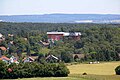
 Fürstenwald - View from the southwest
|
|
Fürstenwald is a village in northern Hesse in the Kassel district and since the Hessian regional reform on April 1, 1972, a district of the municipality of Calden .
Geographical location
Fürstenwald is about 11.5 km (as the crow flies ) northwest of the city center of Kassel . It is located on the northeast edge of the Habichtswald Nature Park, north- northeast of the Dörnberg massif in the headwaters of the Nebelbeeke . With an altitude between about 260 m at the Mühlgraben on the border to the Ehrsten district , 303 m at the train station, 415 m on the Postenberg and 418.5 m on the Hangarstein , Fürstenwald is the highest district of Calden, with Postenberg and Hangarstein, which belong to the Dörnberg massif , the highest elevations in the local area and the municipality of Calden.
history
Fürstenwald is first mentioned in 1332 as Forstinwalde . The original development was almost completely destroyed by a fire in 1883 and the place had to be rebuilt.
The Protestant church in its present form emerged in the second half of the 18th century. The dome and the nave of the late Gothic church (with late Romanesque choir) were renewed in 1782.
The Fürstenwalder Park with the so-called manor house was laid out by Rittmeister Julius König, a freight forwarder from Erfurt, around 1912. In addition, a hunting lodge and a porter's and coachman's apartment were built. The entire complex was completed in 1914 and covers an area of around 4.5 hectares . During the inflation of 1923 he lost his fortune and had to sell the property. After that, the owners changed several times until the Diakonisches Werk of the Protestant regional church acquired it in the 1970s. The Fürstenwald specialist clinic for addicts is located in the park area today - under the sponsorship of the Diakonie .
On April 1, 1972, Fürstenwald was incorporated into the municipality of Calden.
In surviving documents, Fürstenwald was mentioned under the following names (the year it was mentioned in brackets) [LAGIS] : Forstinwalde (1332), Furstewalt (1539) (Kasseler Salbuch ), Fürstenwald.
Fürstenwald specialist clinic and the former manor house
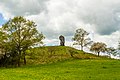
The so-called 'Koppenstein'


Attractions
- Wilhelmsthal Castle (approx. 3.2 km east of the village)
- Natural monument cobblestones (Koppensteine) (approx. 500 m west of the village)
- Habichtswald Nature Park (starting on the southwestern edge of the village)
- Eco path archeology (approx. 2.5 km west of the village)
- Dörnberg (approx. 2.5 km southwest of the village)
Transport links
The county road 30 runs through Fürstenwald , on which you come from the direction of Calden or Zierenberg via Ehrsten to the village. The village can be reached on this road from Kassel via Ahnatal .
Fürstenwald is on the Korbach – Kassel railway line , where the RT4 line runs every half hour. The route is part of the network of the North Hessian RegioTram , which has been running between Wolfhagen and Kassel since December 10, 2006.
The train station is also the end point of bus lines 46 via Ehrsten, Meimbressen and Calden to Vellmar-Nord, line 121 via Calden to Grebenstein and the collective taxi line 122 to the nearby Kassel-Calden airport .
Honorary citizen
- 1895 Otto von Bismarck (1815–1898), Reich Chancellor
literature
- District Hofgeismar, Handbook of the Heimatbund for Kurhessen, Waldeck and Oberhessen III, Marburg / Lahn 1966, p. 90
- Carl Wilhelm Hermann Hochhuth, Statistics of the Protestant Church in the Cassel administrative district, p. 53
- Heinrich Reimer, Historical Local Lexicon for Kurhessen, p. 155
Individual evidence
- ↑ a b Figures and facts in Calden. ( Memento from May 16, 2016 in the Internet Archive ) In: Website. Caldern municipality. Accessed June 2016.
- ^ Federal Statistical Office (ed.): Historical municipality directory for the Federal Republic of Germany. Name, border and key number changes in municipalities, counties and administrative districts from May 27, 1970 to December 31, 1982 . W. Kohlhammer, Stuttgart / Mainz 1983, ISBN 3-17-003263-1 , p. 398 .
Web links
- Fürstenwald (and the other Calden districts), on www.calden.de (municipality website)
- Fürstenwald, district of Kassel. Historical local dictionary for Hessen. In: Landesgeschichtliches Informationssystem Hessen (LAGIS).
- Literature about Fürstenwald in the Hessian Bibliography