
Herbstein
| coat of arms | Germany map | |
|---|---|---|

|
Coordinates: 50 ° 34 ' N , 9 ° 21' E |
|
| Basic data | ||
| State : | Hesse | |
| Administrative region : | to water | |
| County : | Vogelsbergkreis | |
| Height : | 461 m above sea level NHN | |
| Area : | 79.98 km 2 | |
| Residents: | 4692 (Dec. 31, 2019) | |
| Population density : | 59 inhabitants per km 2 | |
| Postal code : | 36358 | |
| Primaries : | 06643, 06647 | |
| License plate : | VB | |
| Community key : | 06 5 35 008 | |
| LOCODE : | DE RBT | |
| City structure: | 8 districts | |
City administration address : |
Marktplatz 7 36358 Herbstein |
|
| Website : | ||
| Mayor : | Bernhard Ziegler ( independent ) | |
| Location of the city of Herbstein in the Vogelsbergkreis | ||
  |
||

Herbstein is a town in the Vogelsbergkreis in central Hesse . The city has been a recognized climatic health resort since 1962 , and since 2000 it has also been a state-approved spa with - according to its own statements - "Hesse's highest mineral spring".
geography
location
Herbstein is located on a former volcanic cone on the eastern cover of the Vogelsberg . The core city is on the German Fairy Tale Route , which leads from Hanau to Bremen . The large community is located in the Hoher Vogelsberg Nature Park . Its lowest geographical point is at 270 m above sea level in the Stockhausen area, the highest point is the Geiselstein in the Oberwald at 720 m.

City structure
In addition to the core city, the municipality consists of the districts Altenschlirf , Lanzenhain , Schlechtenwegen , Steinfurt , Rixfeld , Schadges and Stockhausen .
Neighboring communities
Herbstein borders in the north on the municipality Lautertal , the district town Lauterbach and the municipality Wartenberg , in the east on the municipalities Großenlüder and Hosenfeld (both district Fulda ), in the south on the municipality Grebenhain and in the west on the city of Schotten .
history


Middle Ages and Early Modern Times
Urban development
The oldest surviving mention of Herbstein, as "Heribrahteshusun", can be found in a document from 1011, which attests to a donation to the Fulda monastery and in which it is referred to as "villa".
In 1262 the place received city rights , in 1545 market rights and in 1722 a cattle market. Between 1258 and 1271 the city wall that is still preserved today (and recently restored) was built. It has three defense towers and is now accessible in three places. It was originally 800 meters long and has a wall thickness of 1.40 meters. The masonry is made of basalt . To finance the fortification, the Fulda Abbey had to sell property in the area of the Hameln Abbey . The wall gave the city its defensive shape, which is still visible today. It is visible from afar on a hill. The road system surrounds the parish church in a ring. Within the curtain wall to the east today was a marketplace built castle , which was destroyed 1,642th
Law and administration
Until 1803 the city belonged - after the Reformation as a Roman Catholic enclave in Protestant territory, e.g. B. the rule Riedesel - to the Hochstift Fulda. It originally belonged to the Fulda " Zent Herbstein". This was an extensive area, but it was lost to divestments over time. Herbstein was also pledged many times. The first documented pledge dates from 1321. While the neighboring courts of Krainfeld and Burkhards were permanently lost to the bishopric as a result of the sales, Fulda was able to repurchase the shares in Herbstein between 1584 and 1613 in full.
Herbstein was also an office of the Hochstift Fulda, which was assigned to the Oberamt Herbstein .
In the Herbstein office , Fulda law was applicable . The Common Law was only when the Fuldische law relating to facts contained no provision. When the Amt of Herbstein belonged to the Grand Duchy of Hesse , the Fulda law continued to apply there, only replaced by the Civil Code , which was uniformly applicable throughout the German Empire from January 1, 1900 .
Change of rule
From 1802, Herbstein belonged to the Principality of Nassau-Oranien-Fulda . It was created as a severance payment for the governor who had been expelled from the Netherlands. With regard to jurisprudence and administration, a reorganization of the existing offices was carried out with the rulers' ordinance relating to the superiors and offices of January 8, 1803. The Amt of Herbstein initially remained unchanged as the Stadtschultheissenamt Herbstein and was called “Amt III. Class "classified. By announcement of March 22, 1805, the Provost Office Blankenau and the Stadtschultheißenamt Herbstein were abolished and assigned to the Oberamt Grossenlüder .
In 1806 France occupied the Principality of Nassau-Orange-Fulda. Herbstein was initially under French military administration.
Grand Duchy of Hesse
On May 11, 1810, the Grand Duchy and France signed a state treaty by which France gave territories that it had occupied in 1806 to the Grand Duchy. The treaty concluded in May was not signed by Napoléon until October 17, 1810. The Hessian occupation patent therefore only dates from November 10, 1810. The city now formed the "Herbstein Office", which was supplemented by the town of Ilbeshausen .
From 1820 there were administrative reforms in the Grand Duchy of Hesse. In 1821, jurisdiction and administration were separated at the lower level and all offices were dissolved. For the previously perceived by the offices administrative tasks were district districts created for the first-instance jurisdiction district courts. The previous tasks of the Herbstein Office with regard to administration were transferred to the Herbstein District Council , and the jurisdiction tasks to the Altenschlirf District Court . In 1853 the regional court was moved to Herbstein. On the occasion of the introduction of the Courts Constitution Act with effect from October 1, 1879, as a result of which the previous grand-ducal Hessian regional courts were replaced by local courts in the same place, the name was changed to "Amtsgericht Herbstein" and assigned to the district of the regional court Gießen . “Regional court” now referred to the courts of second instance. From 1943 the Herbstein District Court was only operated as a branch of the Lauterbach District Court before it was finally dissolved in 1968 and added to the Lauterbach District Court area.
Further urban development
In 1907 a large-scale fire destroyed 64 buildings in the city center . The town hall , rebuilt in 1910, is a striking half-timbered building with rich half-timbered decorations. The town inn in the west wing has been privately owned since 1919. Next to it is the former administrative building of the town of schultheissen , who was the official representative of the abbey of Fulda in the town until 1802. The building, which dates from the 16th century, now houses the city pharmacy.
In 1948 the Hessian Minister of the Interior again granted the municipality its town charter and the use of the designation "Stadt Herbstein".
Incorporations
As part of the regional reform in Hesse , seven formerly independent communities with a predominantly Protestant population were incorporated into the Catholic town of Herbstein. These are the villages of Altenschlirf , Lanzenhain , Schlechtenwegen and Steinfurt , which took effect on December 31, 1971, and Rixfeld , Schadges and Stockhausen , which were incorporated by state law on August 1, 1972.
Territorial history and administration
The following list gives an overview of the territories in which Herbstein was located and the administrative units to which it was subordinate:
- before 1803: Holy Roman Empire , Principality of Fulda , Oberamt Herbstein
- from 1803: Holy Roman Empire, Principality of Nassau-Oranien-Fulda (by Reichsdeputationshauptschluss ), Amt Herbstein
- from 1806: Confederation of the Rhine , Principality of Fulda , Amt Herbstein (primatial state of Karl Theodor von Dalberg )
- from 1810: Grand Duchy of Hesse , Gießen administrative district, Herbstein office
- from 1815: German Confederation , Grand Duchy of Hesse, Province of Upper Hesse , Herbstein Office
- from 1821: German Confederation, Grand Duchy of Hesse, Province of Upper Hesse, District District Herbstein (separation between justice ( District Court Altenschlirf ) and administration)
- from 1825: German Confederation, Grand Duchy of Hesse, Province of Upper Hesse, Lauterbach District District
- from 1848: German Confederation, Grand Duchy of Hesse, Alsfeld administrative region
- from 1852: German Confederation, Grand Duchy of Hesse, Province of Upper Hesse, Lauterbach district
- from 1866: North German Confederation , Grand Duchy of Hesse, Province of Upper Hesse, Lauterbach district
- from 1871: German Empire , Grand Duchy of Hesse, Province of Upper Hesse, Lauterbach district
- from 1918: German Empire, People's State of Hesse , Province of Upper Hesse, Lauterbach district
- from 1945: American occupation zone , Greater Hesse , Darmstadt administrative district, Lauterbach district
- from 1949: Federal Republic of Germany , State of Hesse , Darmstadt district, Lauterbach district
- from 1972: Federal Republic of Germany, State of Hesse, Darmstadt administrative district, Vogelsberg district
- from 1981: Federal Republic of Germany, State of Hesse, Gießen district , Vogelsberg district
Population development
Source: Historical local dictionary
- 1961: 268 Protestant (= 15.71%) and 1436 (= 84.17%) Catholic residents
| Herbstein: Population from 1834 to 2015 | ||||
|---|---|---|---|---|
| year | Residents | |||
| 1834 | 1,620 | |||
| 1840 | 1,694 | |||
| 1846 | 1,832 | |||
| 1852 | 1.919 | |||
| 1858 | 2.115 | |||
| 1864 | 1,811 | |||
| 1871 | 1,745 | |||
| 1875 | 1,718 | |||
| 1885 | 1,700 | |||
| 1895 | 1,676 | |||
| 1905 | 1,600 | |||
| 1910 | 1,644 | |||
| 1925 | 1,560 | |||
| 1939 | 1,606 | |||
| 1946 | 2.125 | |||
| 1950 | 2,072 | |||
| 1956 | 1,793 | |||
| 1961 | 1,706 | |||
| 1967 | 1.911 | |||
| 1970 | 1,882 | |||
| 1972 | 4,757 | |||
| 1976 | 4,748 | |||
| 1984 | 4,471 | |||
| 1988 | 4,665 | |||
| 1992 | 5,140 | |||
| 2000 | 5,200 | |||
| 2010 | 4,870 | |||
| 2015 | 4,800 | |||
| Data source: Historical municipality register for Hesse: The population of the municipalities from 1834 to 1967. Wiesbaden: Hessisches Statistisches Landesamt, 1968. Further sources:; 1972 :; 1976 :; 1984 :; 1988 :; 1992 :; 2000 :; 2010: From 1972 including the towns incorporated into Hesse as part of the regional reform . | ||||
religion
Catholic Church of St. James
The population of Herbstein is predominantly Catholic because it belonged to the prince-bishopric of Fulda for centuries. The Catholic Church of St. Jakobus in Herbstein forms the center of the city complex. The parish church is a three-aisled hall construction built around 1500. On both sides of the west tower and on both sides of the choir, side rooms with arcade openings were added to the interior at the end of the 17th century. Its interior is adorned with carvings, reliefs and frescoes, including the larger than life-size crescent Madonna on the first right-hand central pillar in the nave. It dates from the 16th century. The frescoes of the crucifixion group and the handkerchief of St. Veronica and St. Michael fighting with drawings of the clothing and gestures come from the end of the 15th century . There is also the representation of St. Michael with the protective coat motif, including the instruments of Christ's passion. The crucifixion group (around 1700) is on the high altar. There are also late Gothic statues of Peter and Paul (early 16th century), a baroque Vespers picture (around 1700) and St. James (1st half of the 16th century). Today the church is an important stop for reflection for hikers and Pilgrims on the section of the Way of St. James , which leads from Bremen (Geisa) in Thuringia to Munzenberg in the Wetterau.
Protestant church
The Protestant church in Herbstein is located next to the town hall on the city wall. It was inaugurated in 1882 and a tower was added in 1888. Its interior is adorned with wall paintings from the pen of the church painter Kurt Scriba. The pulpit comes from the Lauterbach Chapel of the Dead, which was demolished in 1873. The winged altar, which shows the resurrection of Christ, was donated for the 100th anniversary of the Church of Scriba.

Catholic Church of St. James

Protestant church


politics
City Council
The local elections on March 6, 2016 produced the following results, compared to previous local elections:
| Parties and constituencies |
% 2016 |
Seats 2016 |
% 2011 |
Seats 2011 |
% 2006 |
Seats 2006 |
% 2001 |
Seats 2001 |
||
|---|---|---|---|---|---|---|---|---|---|---|
| CDU | Christian Democratic Union of Germany | 43.3 | 10 | 38.3 | 9 | 38.2 | 12 | 43.5 | 13 | |
| SPD | Social Democratic Party of Germany | 30.3 | 7th | 31.2 | 7th | 27.4 | 8th | 31.0 | 10 | |
| FW | Free voters | 26.4 | 6th | 30.6 | 7th | 34.5 | 11 | 25.6 | 8th | |
| total | 100.0 | 23 | 100.0 | 23 | 100.0 | 31 | 100.0 | 31 | ||
| Voter turnout in% | 58.1 | 53.3 | 49.7 | 56.2 | ||||||
The mayor of Herbstein is Martin Ruhl (as of 2016) .
coat of arms
In March 1952, the city of Herbstein was granted the right to use a coat of arms by the Hessian State Ministry.
Partnerships
The city of Herbstein has had partnership relations with the Belgian municipality of Oelegem (today part of the municipality of Ranst near Antwerp) since 1968 and with the city of Hévíz in Hungary since 1995.
Culture and sights

Museums
There is a “Carnival Museum” in Herbstein. This museum is a reminder of the local carnival tradition that has existed since 1672. This was opened in 1983 in the building of the former district court and has been combined with the "STATT Museum" in Obergasse 7 since May 2008, which has a 19th century pharmacist's room, a doll collection, the former mayor's room and an optical-acoustic representation of the City fire of 1907 shows.
Bible Park

In the summer of 2011, the "first Bible Park in Germany" was opened on the grounds of the Kolping holiday village, along the premium hiking trails Vulkanring and Felsentour Herbstein. Buildings from the Old Testament are reproduced here using wood. Many of them arose in seminars and church set-up times that took place in the Kolping holiday village, during which Bundeswehr soldiers from the deployment areas processed their experiences. Some arrangements, such as Noah's Ark or the Tower of Babel, are accessible and can also be used as children's play equipment. The park is barrier-free accessible; no admission is charged.
Castle vaulted cellar
The Herbsteiner Gewölbe is a system of cellars and corridors at a depth of around 10 meters under the eastern city wall, which was restored for tourism in 1975 and is now partially accessible on guided tours. Its volcanological formation can be attributed to a gaseous volcanic eruption, which raised cinder and volcanic ash ( tuff ) to the top. This layer was not subject to erosion , as it was later covered by another eruption, which hardened after the cooling phase and preserved the tuff layer. In the Middle Ages, the easy-to-work layer was hollowed out - a cellar was created, which u. a. was included in the complex of the Herbsteiner castle complex. The red color of the vaulted cellar walls indicates tropical high temperatures after the volcanic eruption, which gave rise to laterite-colored iron oxides. In 2011 the facility was given the "Geotope of the Year" award by the German Volcanological Society - Vogelsberg Section.
- Pictures of landmarks

Vulkantherme

Vulkantherme with café terrace

Park at the Vulkantherme

Bridge in the spa gardens
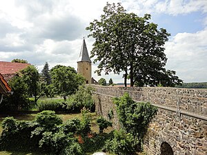
City wall with owl tower

View from the city wall of the Carnival and STATT Museum

Bajazz and Tyrolean couples - traditional figures of the Herbsteiner Carnival

James Fountain


Regular events
- Autumnal Carnival Monday parade with the Springer procession
Economy and Infrastructure
Spa facilities
Thermal spring and VulkanTherme
Since the drilling of a 32.6 ° warm, 1000.05 m deep fluoride-containing calcium-sodium-sulphate thermal spring in 1976, the city has increasingly focused on the spa business. In 1980 the thermal exercise bath, today's Vulkantherme, with a spa center was opened. There is a drinking fountain in the foyer, from which the Herbstein healing water can be tasted. Sauna and bistro with a café terrace were added. There has been a motorhome parking space on the outdoor area of the Vulkantherme since 2008. A medical center with a spa doctor's practice was opened in December 2012. From the Vulkantherme there is a direct connection to the hiking trails Felsentour Herbstein and Vulkanring Vogelsberg , to the Vulkanradweg and to the terrain spa trails in the spa park.
Spa gardens
The extensive landscaped spa park is embedded in the meadow landscape between the volcanic thermal bath and the guest house and is traversed by the Eichhölzchesbach, which also feeds the spa park pond. In the north, the park borders the forest area around the Schalksbach ponds. Within the spa park there are the terrain spa trails, the mini golf course and a boules alley. The park was furnished with accessories from the 1989 Federal Horticultural Show in Frankfurt. B. with whisper bowls and a giant slide for children.
House of the guest with an autumn spiral of life
The Haus des Gastes, built in 1985, serves as a town hall for social occasions. It offers space for approx. 300 guests, has a stage, bowling alley, electric organ and is barrier-free. A spacious outdoor area with a pit-pat play area, grill oven and pavilion rounds off the offer. At the moment the house is not constantly being managed. In front of the guest house is the Herbsteiner Lebensspirale, a meditation path that is accompanied by a watercourse. This symbolizes the human life course and encourages reflection on the experiences that are typically made in the individual phases of life. This outdoor area is barrier-free. There is no entry fee.
Barrier-free old town
The traffic-calmed zone between the Protestant church, the market square, the Jakobusbrunnen, the Carnival and Statt Museum and the parish church of St. Jakobus is barrier-free. The Herbstein Kurverwaltung offers "barrier-free city tours while sitting" for people with limited mobility. For this purpose, seating will be set up at places of tourist interest in the closer city center; the walking distance is only a few 50 meters and the walking pace is very slow. The tour is individually adapted to the respective mobility requirements of people who carry walking aids such as walking sticks, walking frames and wheelchairs.
Volcano cycle path
The volcano cycle path leads in a wide arc around Herbstein. It is located on the route of the former Oberwaldbahn . This cycle path has been part of the Hessen Railway Cycle Path since 2010 . Between the beginning of May and the end of October, the Vulkanexpress bicycle bus runs parallel to the cycle path on Saturdays, Sundays and public holidays.
Hiking trail Felsentour Herbstein
The certified circular hiking trail Felsentour Herbstein is 19 km long and marked with the green-red volcano symbol. It starts and ends at the VulkanTherme Herbstein or from the Kolping Feriendorf Herbstein. It leads through gently undulating terrain, through forests and meadows, and past striking rock formations of volcanism in the Vogelsberg , such as the Felsenruhe near Herbstein and Burgfrieden and Diebstein near Lanzenhain .
Tourism awards
In 2011, the Kurbetriebsgesellschaft Herbstein GmbH was awarded the Hessian Tourism Prize in the category of “Sustainable Tourism Concepts” for its offer of “barrier-free city tours while sitting”. Two years later, the Herbstein Kurverwaltung was among the last four applicants in the “Tourist Marketing Ideas and Concepts” category in the selection process for the Hessian Tourism Prize 2013 carried out by an expert jury. Their offer “Hiking trips with public transport and an advertising block in the middle” was nominated.
traffic
Herbstein was on the Oberwaldbahn from Stockheim to Lauterbach (Hess) , which has now been closed . There are buses to Gedern and Lauterbach (Hess) and to Altenschlirf via Rixfeld . Herbstein is on the B 275 (Lauterbach (Hess) - Bad Schwalbach) .
Personalities
- Wilhelm Dersch (1877–1942), German historian and archivist
- Barbara Kalender (* 1958), German publisher, book designer, writer, blogger
- Michael Ruhl (* 1984), member of the state parliament (CDU), lives in Herbstein
literature
- L. Ewald: Contributions to regional studies . In: Grand Ducal Central Office for State Statistics (ed.): Contributions to the statistics of the Grand Duchy of Hesse . Jonghaus, Darmstadt 1862.
Web links
- Website of the city of Herbstein
- Herbstein, Vogelsbergkreis. Historical local dictionary for Hessen. In: Landesgeschichtliches Informationssystem Hessen (LAGIS).
- Information on the municipality of Herbstein. In: Hessisches Gemeindelexikon. HA Hessen Agentur GmbH , 2016.
- Literature about Herbstein in the Hessian Bibliography
Individual evidence
- ↑ Hessian State Statistical Office: Population status on December 31, 2019 (districts and urban districts as well as municipalities, population figures based on the 2011 census) ( help ).
- ↑ Regional Council Kassel: Regional Council Kassel Complete list of the rated places / districts in Hesse 2014 ( page no longer available , search in web archives ) Info: The link was automatically marked as defective. Please check the link according to the instructions and then remove this notice. (accessed March 25, 2014)
- ^ Schmidt, p. 103f, as well as the enclosed map.
- ^ Text (in French ) in: Schmidt, p. 30ff, note 100.
- ↑ Schmidt, p. 30.
- ↑ Schmidt, p. 33.
- ^ Ilbeshausen-Hochwaldhausen, Vogelsbergkreis . In: LAGIS : Historical local dictionary ; As of October 16, 2018.
- ^ Ordinance on the division of the country into districts and district courts of July 14, 1821 . In: Hessisches Regierungsblatt No. 33 of July 20, 1821, pp. 403ff.
- ^ Ordinance on the division of the country into districts and district courts of July 14, 1821 . In: Hessisches Regierungsblatt No. 33 of July 20, 1821, p. 414.
- ^ Ordinance on the implementation of the German Courts Constitution Act and the Introductory Act to the Courts Constitution Act of May 14, 1879 . In: Grand Duke of Hesse and the Rhine (ed.): Grand Ducal Hessian Government Gazette. 1879 no. 15 , p. 197–211 ( online at the information system of the Hessian state parliament [PDF; 17.8 MB ]).
- ↑ Granting of town charter to the municipality of Herbstein, Lauterbach district on June 12, 1948 . In: The Hessian Minister of the Interior (ed.): State Gazette for the State of Hesse. 1948 no. 26 , p. 261 , point 296 ( online at the information system of the Hessian state parliament [PDF; 2.9 MB ]).
- ↑ Law on the reorganization of the Alsfeld and Lauterbach districts (GVBl. II 330-12) of August 1, 1972 . In: The Hessian Minister of the Interior (ed.): Law and Ordinance Gazette for the State of Hesse . 1972 No. 17 , p. 215 , § 7 ( online at the information system of the Hessian state parliament [PDF; 1,2 MB ]).
- ^ Federal Statistical Office (ed.): Historical municipality directory for the Federal Republic of Germany. Name, border and key number changes for municipalities, counties and administrative districts from May 27, 1970 to December 31, 1982 . W. Kohlhammer GmbH, Stuttgart and Mainz 1983, ISBN 3-17-003263-1 , p. 367 and 368 .
- ↑ a b c Herbstein, Vogelsbergkreis. Historical local dictionary for Hessen. (As of May 24, 2018). In: Landesgeschichtliches Informationssystem Hessen (LAGIS).
- ^ Michael Rademacher: German administrative history from the unification of the empire in 1871 to the reunification in 1990. State of Hesse. (Online material for the dissertation, Osnabrück 2006).
- ^ Local elections 1972; Relevant population of the municipalities on August 4, 1972 . In: The Hessian Minister of the Interior (ed.): State Gazette for the State of Hesse. 1972 No. 33 , p. 1424 , point 1025 ( online at the information system of the Hessian state parliament [PDF; 5.9 MB ]).
- ↑ Local elections 1977; Relevant population figures for the municipalities as of December 15, 1976 . In: The Hessian Minister of the Interior (ed.): State Gazette for the State of Hesse. 1976 No. 52 , p. 2283 , point 1668 ( online at the information system of the Hessian state parliament [PDF; 10.3 MB ]).
- ^ Local elections 1985; Relevant population of the municipalities as of October 30, 1984 . In: The Hessian Minister of the Interior (ed.): State Gazette for the State of Hesse. 1984 No. 46 , p. 2175 , point 1104 ( online at the information system of the Hessian state parliament [PDF; 5.5 MB ]).
- ^ Local elections in 1989; Relevant population figures for the municipalities as of October 25, 1988 . In: The Hessian Minister of the Interior (ed.): State Gazette for the State of Hesse. 1988 No. 45 , p. 2426 , point 1049 ( online at the information system of the Hessian state parliament [PDF; 4.6 MB ]).
- ↑ local elections 1993; Relevant population of the municipalities as of October 21, 1992 . In: The Hessian Minister of the Interior (ed.): State Gazette for the State of Hesse. 1992 No. 44 , p. 2766 , point 935 ( online at the information system of the Hessian state parliament [PDF; 6.1 MB ]).
- ↑ Municipal data sheet : Herbstein. (PDF; 222 kB) In: Hessisches Gemeindelexikon. HA Hessen Agency GmbH
- ↑ The population of the Hessian communities on June 30, 2010. (PDF; 552 kB) Hessisches Statistisches Landesamt, p. 11 , archived from the original on February 7, 2018 ; accessed on March 20, 2018 .
- ^ Result of the municipal election on March 6, 2016. Hessian State Statistical Office, accessed in April 2016 .
- ^ Hessian State Statistical Office: Result of the municipal elections on March 27, 2011
- ^ Hessian State Statistical Office: Result of the municipal elections on March 26, 2006
- ↑ Granting of the right to use a coat of arms to the city of Herbstein in the Lauterbach district, Darmstadt administrative district on March 1, 1952 . In: The Hessian Minister of the Interior (ed.): State Gazette for the State of Hesse. 1952 No. 15 , p. 280 , point 351 ( online at the information system of the Hessian state parliament [PDF; 2.7 MB ]).

Alsfeld | Drift Valley | Feldatal | Freiensteinau | Gemünden (Felda) | Grebenau | Grebenhain | Herbstein | Homberg (Ohm) | Kirtorf | Lauterbach | Lautertal (Vogelsberg) | Mosquito | Romrod | Slot | Bulkheads | Schwalmtal | Ulrichstein | Wartenberg
Altenschlirf | Herbstein | Lance Grove | Rixfeld | Schadges | Bad ways | Steinfurt | Stockhausen