Bremen (Geisa)
|
Bremen
Geisa municipality
Coordinates: 50 ° 43 ′ 26 ″ N , 10 ° 0 ′ 9 ″ E
|
|
|---|---|
| Height : | 363 m above sea level NN |
| Residents : | 275 (2012) |
| Incorporation : | March 8, 1994 |
| Postal code : | 36419 |
| Area code : | 036967 |
|
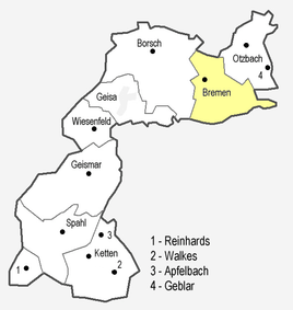
Location of Bremen
|
|
|
Partial view of the baroque church (1911).
|
|
Bremen is a district of Geisa in the Wartburg district in Thuringia .
location
Bremen is close to the Hessian-Thuringian border on the northwestern roof of the Thuringian Rhön . The district is located east of the core community on Landesstraße 1026 , which has a connection to Bundesstraße 278 in Geisa . The geographic height of the place is 363 m above sea level. NN .
history
The village was first mentioned on April 20, 1150. The origin of the village name, in particular a possible connection to the Hanseatic city of the same name, is open. The Bremen churchyard also has historical roots. In the Turkish tax register of the prince abbey of Fulda from 1605 the place is mentioned under the name Bremenn with 50 families. With the fall of the Wall , the population was freed from the border problems of the post-war period - until 1990 the town was in the restricted area along the inner-German border . Bremen merged on March 8, 1994 through a joint contract with the towns of Borsch , Geisa, Wiesenfeld , Otzbach and Geblar to form the Geisa community. In 2019, 322 people live in Bremen.
Attractions
- Catholic baroque church St. Jakobus the Elder , built between 1730 and 1735, with an organ by Johann Markus Oestreich , which was restored in 2002 by Orgelbau Waltershausen
- Rectory from 1713; the oldest surviving building in Bremen, southeast of the church
- Lourdes grotto on the slope of the Wartberg; Erected in 1918 by parishioners
Economy and Infrastructure
Agriculture
During the GDR era, the farmers in the area work together in the LPG Type III Karl Liebknecht based in Bremen for plant production and the LPG Type III Vorderrhön in Geisa in animal production (cattle fattening and milk production). After the fall of the Berlin Wall , the agricultural cooperative " Ulstertal " emerged from the LPGs and is based in Bremen.
Water supply
To the east of the town, the headwaters of the Bremenbach are used for the public water supply . Parts of the corridor are located in a water protection area . On the western outskirts there is a waterworks that supplies Bremen, Geisa and the surrounding areas with drinking water.
Web links
Individual evidence
- ↑ Official topographic maps of Thuringia 1: 10,000. Wartburgkreis, district of Gotha, district-free city of Eisenach . In: Thuringian Land Survey Office (Hrsg.): CD-ROM series Top10 . CD 2. Erfurt 1999.
- ^ Wolfgang Kahl : First mention of Thuringian towns and villages. A manual. Rockstuhl Verlag, Bad Langensalza, 2010, ISBN 978-3-86777-202-0 , p. 41
- ↑ Michael Köhler: Thuringian castles and fortified prehistoric and prehistoric living spaces Jenzig-Verlag, 2001, ISBN 3-910141-43-9 , p. 73
- ↑ Thomas Heiler: The Turkish tax register of the prince abbey of Fulda from 1605, (Publication of the Fuldaer Geschichtsverein in the Fuldaer Geschichtsbl Blätter; No. 64), Fulda, Parzeller-Verlag, 2004, ISBN 3-7900-0362-X , place register on pages 37– 47, from there reference to the page with the number of taxpayers
- ↑ Bremen on the website of the city of Geisa.Retrieved on May 18, 2012


