Chains (geisa)
|
Chains
Geisa municipality
Coordinates: 50 ° 38 ′ 48 ″ N , 9 ° 55 ′ 44 ″ E
|
|
|---|---|
| Height : | 400 m above sea level NN |
| Residents : | 202 (December 31, 2009) |
| Incorporation : | March 25, 1994 |
| Incorporated into: | Rockenstuhl |
| Postal code : | 36419 |
| Area code : | 036967 |
|
The location of the place
|
|
|
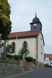
The Church in Chains (2013)
|
|
Ketten is a district of Geisa in the Wartburg district in Thuringia .
location
The district of Ketten is located in the Rhön Biosphere Reserve , at the foot of the 639.4 meter high Rößberg on the Hessian-Thuringian border south of Geisa. The southwestern neighboring town is Gotthards in Hesse . Ketten lies in the southernmost tip of the Wartburg district. The geographical height of the place is 400 m above sea level. NN .
history
The place name Ketten was first mentioned in 1062. This is followed by a document from March 9, 1186. In the Middle Ages, the village belonged to the dominion of the Fulda monastery , it was assigned to the office of Rockenstuhl . The lower jurisdiction and administration was exercised by a local nobleman. The former castle of the Herren von Ketten was demolished around 1790. At this time the place was already part of the rule of the Lords of Tann , they owned the village from the 16th to the 18th century. In the center of the village there is a small St. George's Church , which was restored in 1807. There is an abandoned quarry on the outskirts, which provided work opportunities for the farmers in winter. After the end of the Second World War, Ketten was in the strictly guarded border area and could only be visited with a pass over a single road connection. The isolation of the village prevented any economic development. In mid-January 1990, the last barricades of the border security and signal fence (GSSZ) in the 500-meter-wide “death corridor”, which had blocked the ancient connection between Motzlar and Ketten for almost 30 years, were removed. Thus, the route for the supply vehicles was ten kilometers shorter and thus also the route to the Federal Republic of Germany. After 1990, a full-time farmer in Ketten took over the management of the agricultural land, and he sells Rhön sausage specialties in his farm shop. A significant part of the corridor along the border strip was dedicated to nature conservation and forms the maintenance zone of the biosphere reserve. It was with dismay that the population welcomed plans to expand the protected area in the summer of 2012. The consultations, which have been personally moderated by Thuringian Agriculture Minister Jürgen Reinholz since September 2012 , are intended to bring about an amicable solution between the legitimate interests of the residents, the farms and nature conservation concerns.
Tourism has an increasing value in the border region, which has not yet been developed industrially. From March 25, 1994 to December 30, 2008 Geismar, Ketten, Spahl, Walkes, Reinhards and Apfelbach formed the Rockenstuhl community .
Culture and sights
In 1947 a field cross was erected on the summit of the Rößberg. The majority of the population is Catholic and practices the customs and feast days of the church year. In 2007, some residents of Ketten built a small St. Mary's grotto on the outskirts . The inhabitants of the place go to the so-called "Bildtannenfest" (picture fir festival) to a place on the corridor border to Gotthards. The cultural life is also shaped in chains by the carnival club and the fun fair club, and there is also a fire brigade club.
literature
- Michael Mott : After 30 years of waiting / The last barricades of the border security and signal fence have fallen: Direct path between Ketten and Motzlar is free again , in: Fuldaer Zeitung , Jan. 26, 1990, p. 14.
- Michael Mott: The Buchische knight family of chains / Fuldaer Ministerials from the 12th to the 15th century , in: "Buchenblätter", Fuldaer Zeitung , 65th year, July 8th 1992, pp. 69–70, July 13th 1992, pp. 73-74, July 28, 1992, pp. 77-78.
Web links
Individual evidence
- ↑ Official topographic maps of Thuringia 1: 10,000. Wartburgkreis, district of Gotha, district-free city of Eisenach . In: Thuringian Land Survey Office (Hrsg.): CD-ROM series Top10 . CD 2. Erfurt 1999.
- ^ Wolfgang Kahl : First mention of Thuringian towns and villages. A manual. Verlag Rockstuhl, Bad Langensalza, 2010, ISBN 978-3-86777-202-0 , p. 140.
- ↑ Compromise in the biosphere reserve: agreement with farmers. Südthüringer Zeitung, local page Bad Salzungen, September 12, 2012, accessed on September 12, 2012 : “The Minister of the Environment expressed understanding for the Rhön property owners, especially with regard to the experiences from the restricted area. 'No land will be taken from the people, there will be no dispossession,' he promised. After the farmers declared the moderation process to have failed a few weeks ago, and the state parliament members Manfred Grob and Michael Heym (both CDU) intervened, there were further rounds of talks, the last one immediately before the public event on Monday. The result was a compromise that Dr. Aribert Bach, Vice President of the Thuringian Farmers' Association, presented. 'We discussed factually and constructively, but very critically,' he said. For example, a new category B is defined for agricultural areas that are to be added to the maintenance zone. 'No arable land should be affected, only grassland.' "
- ↑ Chains on the website of the city of Geisa.Retrieved May 18, 2012.
- ↑ StBA: Changes in the municipalities in Germany, see 1994


