Rockenstuhl
Rockenstuhl is the name of a former municipality in the Wartburg district in Thuringia .
geography
The former municipality is located in the southwestern tip of Thuringia and the Wartburg district - at the Rockenstuhl mountain ( 529 m above sea level ), a basalt cone and the region's landmark. It included the districts of Reinhards , Geismar , Ketten , Spahl , Walkes and Apfelbach and an area of 30.39 km². Reinhards is the westernmost point of Thuringia, the GDR and the Warsaw Pact ( → coordinates:) . Most recently, 1353 inhabitants lived in the municipality. (As of December 31, 2007)
The western, southern and eastern border of Rockenstuhl is at the same time the border with Hesse , the northern border is that of the district of Schleid and, before it was incorporated into Geisa, also that of the city of Geisa. The distinctly hilly landscape is characterized by agricultural areas and wooded heights. The country road 2603 leads through the area from Geisa in the direction of Hesse, where it leads to Mittelaschenbach when it enters Hessian territory as district road 126 . Other roads are the K 95 (Spahl – Ketten– [K 128] - Gotthards ), the K 94 / K 94B ( Motzlar –Apfelbach – Ketten) and the K 94 / K 31 (Apfelbach– Neuswarts ).
The most important river in the municipality is the Ulster , which flows on the northeastern edge and is a tributary of the Werra . From the Rockenstuhl area, only the Apfelbach flows into it from the left, some of which is the south-eastern border river to Hesse, and the Geisa , which flows into the Ulster in Geisa. The Geisa has several source streams to the southwest and west (in the NSG Teufelsberg-Pietzelstein) of Spahl, flows through this place in a northerly direction, then takes in further source streams and meanders on the way to the mouth of Geismar.
history
In the course of the regional reform in Thuringia, the municipalities of Geismar, Ketten and Spahl merged on March 25, 1994 to form the municipality of Rockenstuhl. The community name comes from the mountain Rockenstuhl.
At the request of the residents, the Rockenstuhl community was incorporated into the neighboring town of Geisa on December 31, 2008 . The places Geismar, Ketten and Spahl form with Apfelbach, Reinhards and Walkes the district Geismar / Spahl / Ketten / Apfelbach / Reinhards / Walkes with a common district constitution.
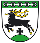
coat of arms
The coat of arms was designed by the heraldist Uwe Reipert.
Web links
Individual evidence
- ↑ StBA: Changes in the municipalities in Germany, see 1994
- ↑ StBA Area: changes from 01.01. until December 31, 2008
- ↑ Main statute of the city of Geisa, § 3 (PDF file; 33 kB)
Coordinates: 50 ° 24 ' N , 9 ° 34' E

