
Homberg (Ohm)
| coat of arms | Germany map | |
|---|---|---|
_COA.svg)
|
Coordinates: 50 ° 44 ' N , 9 ° 0' E |
|
| Basic data | ||
| State : | Hesse | |
| Administrative region : | to water | |
| County : | Vogelsbergkreis | |
| Height : | 259 m above sea level NHN | |
| Area : | 88.02 km 2 | |
| Residents: | 7427 (Dec. 31, 2019) | |
| Population density : | 84 inhabitants per km 2 | |
| Postal code : | 35315 | |
| Primaries : | 06633, 06429 | |
| License plate : | VB | |
| Community key : | 06 5 35 009 | |
| City structure: | 14 boroughs | |
City administration address : |
Marktstrasse 26 35315 Homberg (Ohm) |
|
| Website : | ||
| Mayor : | Claudia Blum ( SPD ) | |
| Location of the city of Homberg (Ohm) in the Vogelsberg district | ||
  |
||

Homberg (Ohm) is a town in the Vogelsbergkreis in central Hesse .
geography
location
The state-approved health resort Homberg is located about 19 km southeast of Marburg on the southeastern edge of the Amöneburger basin ( Ohmtalsenke ) and on the southwest slopes of the northern Vogelsberg foothills counted, 358-meter high mountain it (in Homberg also high mountain called) and its offshoots (in East the 349 m high Wilchesburg ).
Beyond the parts of the city on a good 200 m above sea level flowing through Ohm , a tributary of the Lahn , the city lies immediately south of the 331 m high Herrmannsberg , about five kilometers west-northwest the 407 m high Mardorfer Kuppe - both elevations of the Lumda plateau ("Vorderer Vogelsberg").
While the Vorderer Vogelsberg and Nördliches Vogelsberg-Vorland have the Vogelsberg in their name, but still belong to the West Hessian highlands , the district of Homberg meets the Untere Vogelsberg , a good four kilometers south of the core town , which, although not in height, is geologically part of the Vogelsberg can be counted in the broader sense and, like this one, belongs to the East Hessian mountainous region.
All the surrounding mountain ranges have in common that less than half of their area is forested and that they have a high density of wind turbines .
Neighboring communities
Homberg borders the city of Stadtallendorf ( Marburg-Biedenkopf district ) in the north, the city of Kirtorf in the northeast, the municipality of Gemünden in the southeast, the municipality of Mücke in the south, and the town of Grünberg and the municipality of Rabenau (both in the district of Gießen ), to the west to the municipality of Ebsdorfergrund , and to the northwest to the city of Amöneburg (both districts of Marburg-Biedenkopf).
City structure
The city of Homberg consists of the eponymous core city of the districts Appenrod , Bleidenrod , Büßfeld , Dannenrod , ceilingbach , Erbenhausen , Gontershausen , Haarhausen , Höingen , Maulbach , Nieder-Ofleiden , Ober-Ofleiden and Schadenbach .

history
It was King Heinrich IV who, at the request of his mother Agnes, gave the Hersfeld monastery "ten hooves" with all accessories in "Hohunburch" in the county of Werner III. in the Lahngau. That was in 1065 AD and this is the first official mention of Homberg. It is no longer possible to determine when the mountain in the Ohm valley was first settled.
Another donation to the Hersfeld monastery was dated in 1146 , this time from King Konrad III. , who ceded half of his property to the monastery, but with the express note that the mountain itself had to remain in royal possession. From this information we can conclude that there must have been a castle in Homberg as early as the 12th century. The granting of town charter cannot be precisely dated either - Homberg was first mentioned as a town from the year 1234. There is also some other evidence that Homberg already had a fixed town structure at that time.

The ruins of Homberg Castle (Schloss Homberg) from the 11th century are located on the Schlossberg near Homberg .
The first coat of arms of the city of Homberg shows a typical motif for a landgrave city these days. A stylized city castle over a clover leaf arch, under which a lion walks to the left . This coat of arms and the intensive efforts of the Thuringian landgrave to found cities suggest that it was this landgrave to whom Homberg owes its long history as a city. A number of other cities were founded in this way, including Alsfeld and Marburg . The landgraves had the goal of creating financial and military bases in the country, so the country should be secured.
Also appearing on the Ludowinger following Hessian Landgrave followed this strategy. Homberg gained importance as the seat of a landgrave's office and a city and regional court. According to an entry from 1587, the Homberg district also included the villages of Appenrod, Büßfeld, ceilingbach, Höingen, Ehringshausen, Gontershausen, Haarhausen, Maulbach, Nieder-Ofleiden, Ober-Ofleiden, Schadenbach, Rülfen and the Wäldershausen estate. This division was adopted almost unchanged during the municipal reform of 1972, whereby Ehringshausen and Rülfenrod do not belong to the city of Homberg, but Maulbach, Bleidenrod and Dannenrod do. Homberg's castle served as the official residence and residence for landgrave officials. Even in its current appearance, the castle still reveals a lot from the 13th and 15th centuries, even though the keep was finally destroyed in the Thirty Years War . In the years that followed, the castle itself was often lent as a pledge, as the landgraves wanted to borrow money from the nobles in the area.
Landgrave Philipp the Magnanimous died in 1567 and he had decreed in his will that Homberg should belong to Hessen-Marburg , but in 1604 the city became part of Hessen-Darmstadt.
In the Middle Ages, Homberg not only played an important role as a judicial and administrative hub on the edge of the Vogelsberg. A mint was mentioned in Homberg as early as the 13th century. In addition, the convenient location between the Leipzig and Frankfurt trading centers also ensured good development as a market location. Even Philip the Magnanimous had given Homberg the first market privileges in 1554. Six cattle and junk markets were held each year, of which the cold market held on the third Wednesday in October has survived to this day. The town became more economical with the wine and brandy law (from 1671) and the brewery. Schools were mentioned as early as 1529.
The town church, which to this day has a characteristic roof shape due to lack of money, was built in the first half of the 13th century. In addition, there was an even older castle chapel until around 1700, which then fell into disrepair. The cemetery chapel, which was built in the late Gothic style in 1565, is mentioned again and again. The reason for the construction of its own cemetery chapel was the relocation of the burial place to the outside.
The initial economic rise of Homberg was strongly curbed by disasters and epidemics. Many large fires made the Hombergers to create, especially in 1657 almost the entire city was destroyed in a large fire. The Thirty Years' War also brought little good for Homberg. Three campaigns reached Homberg in 1635, 1641 and 1646, during which the city was destroyed and devastated. In contrast, Homberg was halfway spared in the Seven Years' War , but suffered from billeting.
In 1750, Homberg had again reached the 1,000 population limit for the first time since the great population losses in the Thirty Years War. Around 1,800 people lived in the city in the mid-19th century. In the period that followed, the population shrank again by a quarter, as many Hombergers emigrated to the USA . According to a census of 1840 Homberg had 1,743 inhabitants.
The statistical-topographical-historical description of the Grand Duchy of Hesse reports on Homberg an der Ohm in 1830:
“Homberg (L. Bez. Kirtorf) city; lies on the Ohm, 2 St. von Kirtorf and 1266 Hess. (974 par.) Feet above the sea on a basalt mountain. The city has 251 houses and 1659 inhabitants, who are Protestant apart from 3 Catholics and 88 Jews, then 2 churches, 1 castle, 1 town hall, 1 brewery, 7 grinding mills and 1 pharmacy. The castle, located at a height above the city, used to be the seat of the judiciary and is now the rent office apartment. Homberg is also the seat of the regional court and the tax commissioner. 269 of the inhabitants are engaged in civil trades and 6 are real farmers; among the first there are several tanners and woolen weavers. In the area there is a basalt quarry on the grove and a break in white sandstones on the way to Maulbach, which can only be used as masonry stones. 2 grocer's and 3 grocer's and cattle markets are held annually. - Homberg appears in 1065 under the name Hohunburch , and is not mentioned again until 1293, when Landgrave Heinrich I left a part of Upper Hesse to his son Otto. A document from 1328 names it as a castle. At that time, Landgrave Heinrich II donated an altar in the church. But Homberg already appears as a town in 1371. In 1436, the city and its accessories came as a pledge for 4,000 Rthlr. Gold gulden, to parakeet von Berlepsch. In the past, the city owned the Riedesel and Milchling Schutzpar as a deposit. "
In 1938 the city had 1,482 inhabitants, the official name at that time was Homberg (Upper Hesse) .
After the Second World War , the city developed more and more into a middle center for the middle Ohmtal, to which the settlement of industrial companies made a significant contribution.
On December 20, 1973 the city name Homberg (Alsfeld district) was officially changed to Homberg (Ohm) ; the district had already been dissolved on August 1, 1972 and merged into the Vogelsbergkreis.
Incorporations
On October 1, 1971, the communities Appenrod, Bleidenrod, Büßfeld, Dannenrod, Erbenhausen, Gontershausen, Haarhausen, Höingen, Maulbach, Ober-Ofleiden and Schadenbach were incorporated. On December 31, 1971, Bettenbach and Nieder-Ofleiden were added.
Territorial history and administration
The following list gives an overview of the territories in which Homberg (Ohm) was located and the administrative units to which it was subordinate:
- before 1567: Holy Roman Empire , Landgraviate of Hesse , Office Homberg an der Ohm
- from 1567: Holy Roman Empire, Landgraviate Hessen-Marburg , Office Homberg an der Ohm
- 1604–1648: disputed between Landgraviate Hessen-Darmstadt and Landgraviate Hessen-Kassel ( Hessenkrieg ), Office Homberg an der Ohm
- from 1604: Holy Roman Empire, Landgraviate Hesse-Darmstadt, Upper Duchy of Hesse , Office Homberg an der Ohm
- from 1806: Grand Duchy of Hesse , Upper Duchy of Hesse , Office Homberg an der Ohm
- from 1815: German Confederation , Grand Duchy of Hesse, Province of Upper Hesse , Office Homberg an der Ohm
- from 1821: German Confederation, Grand Duchy of Hesse, Province of Upper Hesse, District District Kirtorf (separation between justice ( District Court Homberg an der Ohm ) and administration)
- from 1832: German Confederation, Grand Duchy of Hesse, Province of Upper Hesse, Alsfeld district
- from 1848: German Confederation, Grand Duchy of Hesse, Alsfeld administrative region
- from 1852: German Confederation, Grand Duchy of Hesse, Province of Upper Hesse, Alsfeld district
- from 1866: North German Confederation , Grand Duchy of Hesse, Province of Upper Hesse, Alsfeld district
- from 1871: German Empire , Grand Duchy of Hesse, Province of Upper Hesse, Alsfeld district
- from 1918: German Empire, People's State of Hesse , Province of Upper Hesse, Alsfeld District
- from 1945: American zone of occupation , Greater Hesse , Darmstadt administrative district, Alsfeld district
- from 1949: Federal Republic of Germany , State of Hesse , Darmstadt administrative district, Alsfeld district
- from 1972: Federal Republic of Germany, State of Hesse, Darmstadt administrative district, Vogelsberg district
- from 1981: Federal Republic of Germany, State of Hesse, Gießen district , Vogelsberg district
- from 1993: European Union , Federal Republic of Germany, State of Hesse, Gießen district , Vogelsberg district
Courts since 1803
In the Landgraviate of Hesse-Darmstadt , the judicial system was reorganized in an executive order of December 9, 1803. The “Hofgericht Gießen” was set up as a court of second instance for the province of Upper Hesse . The jurisdiction of the first instance was carried out by the offices or landlords and thus the "Office Homberg an der Ohm" was responsible for Homberg. The court court was the second instance court for normal civil disputes, and the first instance for civil family law cases and criminal cases. The superior court of appeal in Darmstadt was superordinate .
With the establishment of the Grand Duchy of Hesse in 1806, this function was retained, while the tasks of the first instance were transferred to the newly created regional courts in 1821 as part of the separation of jurisdiction and administration. " Regional Court Homberg an der Ohm " was therefore from 1821 to 1879 the name of the court of first instance in Homberg an der Ohm, which was now responsible for Homberg.
On the occasion of the introduction of the Courts Constitution Act with effect from October 1, 1879, as a result of which the previous grand-ducal Hessian regional courts were replaced by local courts at the same place, while the newly created regional courts now functioned as higher courts, the name was changed to "Local Court Homberg an der Ohm" and Allocation to the district of the regional court in Giessen . On June 15, 1943, the court became a branch of the Alsfeld District Court, but was converted into a full court again with effect from June 1, 1948. On July 1, 1968, the district court was dissolved, and Homberg was assigned to the area of the Kirchhain district court. In 1973, Homberg moved to the jurisdiction of the Alsfeld District Court . The regional court of Giessen , the higher regional court of Frankfurt am Main and the Federal Court of Justice are now in higher-level instances.
population
Population structure
According to the 2011 census , there were 7659 inhabitants in Grünberg on May 9, 2011. Among them were 353 (4.6%) foreigners, of whom 169 came from outside the EU , 142 from other European countries and 42 from other countries. The inhabitants lived in 3123 households. 880 of these were single households , 952 couples without children and 1019 couples with children, as well as 244 single parents and 28 shared apartments .
Population development
| • 1791: | 1271 inhabitants |
| • 1800: | 1357 inhabitants |
| • 1806: | 1569 inhabitants, 251 houses |
| • 1829: | 1659 inhabitants, 251 houses |
| • 1867: | 1478 inhabitants, 238 inhabited buildings |
| • 1875: | 1486 inhabitants, 251 inhabited buildings |
| Homberg (Ohm): Population from 1791 to 2015 | ||||
|---|---|---|---|---|
| year | Residents | |||
| 1791 | 1,271 | |||
| 1800 | 1,357 | |||
| 1806 | 1,569 | |||
| 1829 | 1,659 | |||
| 1834 | 1,764 | |||
| 1840 | 1,788 | |||
| 1846 | 1,806 | |||
| 1852 | 1,735 | |||
| 1858 | 1,607 | |||
| 1864 | 1,551 | |||
| 1871 | 1,465 | |||
| 1875 | 1,486 | |||
| 1885 | 1,461 | |||
| 1895 | 1,290 | |||
| 1905 | 1,205 | |||
| 1910 | 1.317 | |||
| 1925 | 1,378 | |||
| 1939 | 1,479 | |||
| 1946 | 2,305 | |||
| 1950 | 2,368 | |||
| 1956 | 2,423 | |||
| 1961 | 2,835 | |||
| 1967 | 3,167 | |||
| 1970 | 3,365 | |||
| 1972 | 7,465 | |||
| 1975 | 7,525 | |||
| 1980 | 7,439 | |||
| 1985 | 7,445 | |||
| 1990 | 7,714 | |||
| 1995 | 8,024 | |||
| 2000 | 8,086 | |||
| 2005 | 7,929 | |||
| 2010 | 7,628 | |||
| 2011 | 7,659 | |||
| 2015 | 7,568 | |||
| Data source: Historical municipality register for Hesse: The population of the municipalities 1834 to 1967. Wiesbaden: Hessisches Statistisches Landesamt, 1968. Further sources: 1972 :; from 1975 :; 2011 census From 1972 including the towns incorporated into Hesse as part of the regional reform . | ||||
Religious affiliation
| • 1829: | 1569 Protestant (= 94.58%), 88 Jewish (= 5.30%), 3 Roman Catholic (= 0.18%) residents |
| • 1961: | 2084 Protestant (= 73.51%), 645 Catholic (= 22.75%) inhabitants |
| • 2011: | 5343 Protestant (= 69.8%), 1052 Catholic (= 13.7%), 1,264 other (= 16.4%) residents |
religion
-002.jpg)
Evangelical
The church building of the Protestant town church at the town church 7 is in Homberg.
Catholic
Since the end of World War II , the number of Catholic believers in Homberg / Ohm has increased steadily. The reason for this was the large number of displaced people who quickly found a new home here. In the first years the Protestant town church was the place where the Catholic parishioners celebrated Holy Mass. On July 16, 1950, the cemetery chapel was consecrated as a Catholic church. This late Gothic half-timbered building from 1565 was only a temporary solution. The cramped space in the cemetery chapel soon made it clear that only a new building could remedy this. In 1957 two private properties were bought and the foundation stone was laid on July 3, 1960 . On April 30th and May 1st, 1961 the time had finally come. With a large participation of the parishioners , the Bishop of Mainz , Dr. Albert Stohr entered the St. Matthias Church at 49 Burgring in Homberg. After years of improvisation, the Catholic community in Homberg / Ohm now had a church .
politics
mayor
According to the Hessian municipal constitution, the mayor is the chairman of the magistrate , which in the town of Homberg (Ohm) includes six voluntary councilors in addition to the mayor . Mayor is Claudia Blum (SPD). She was elected in a runoff election on March 20, 2016 with a turnout of 63.3 percent with 54.5 percent and replaced Béla Dören (SPD), who had not run for re-election, on July 1, 2016. In the previous election period, Béla Dören won the election on March 14, 2010 against incumbent Volker Orth (non-party) and was then appointed mayor on June 29, 2010 in the city council. Two days later, on July 1, 2010, he took office.
City Council
The local elections on March 6, 2016 produced the following results, compared to previous local elections:
| Parties and constituencies |
% 2016 |
Seats 2016 |
% 2011 |
Seats 2011 |
% 2006 |
Seats 2006 |
% 2001 |
Seats 2001 |
||
|---|---|---|---|---|---|---|---|---|---|---|
| CDU | Christian Democratic Union of Germany | 48.4 | 13 | 40.5 | 11 | 36.0 | 10 | 32.9 | 10 | |
| SPD | Social Democratic Party of Germany | 33.7 | 9 | 39.3 | 11 | 39.7 | 11 | 40.8 | 13 | |
| FW | Free voters | 9.5 | 3 | 16.2 | 4th | 18.5 | 5 | 20.7 | 6th | |
| GREEN | Alliance 90 / The Greens | 8.3 | 2 | - | - | - | - | - | - | |
| FDP | Free Democratic Party | - | - | 4.0 | 1 | 5.8 | 1 | 5.6 | 2 | |
| total | 100 | 27 | 100 | 27 | 100 | 27 | 100 | 31 | ||
| Voter turnout in% | 64.1 | 54.4 | 50.2 | 54.4 | ||||||
Town twinning
The city of Homberg maintains partnership relationships with Thouaré-sur-Loire on the Loire in France (since 1981) and Stadtroda in Thuringia (since 1990).
coat of arms
|
|
Blazon : “In blue over a golden (yellow) cloverleaf arch a silver (white) castle with a central tower, flanked by two smaller towers with red roofs; under the cloverleaf arch the golden (yellow) crowned colorful Hessian lion striding to the left. " |
| Justification of the coat of arms: The coat of arms is derived from seals from the 13th century, which until 1274 showed the Thuringian and then the Hessian lion. At times there was uncertainty about the timing . The current one follows the design by Otto Hupp |
banner
.svg) |
Banner: "The banner is blue and white striped lengthways with the coat of arms above the middle." |
Culture and sights
societies
- Express train Homberg
- FSG Homberg / Ober-Ofleiden
- Nieder-Ofleiden volunteer fire brigade
- Choral society "Harmonie" Nieder-Ofleiden
- Country women's association "Ohmtal" Nieder-Ofleiden
- SV "Viktoria 1921" Nieder-Ofleiden
- Fraternity 1963 Nieder-Ofleiden
- TV Homberg 1862
- Minstrel and fanfare corps of the Homberg volunteer fire brigade (Ohm)
- SG Appenrod / Maulbach
- TTG Büßfeld
- BSE Büßfeld
- Rural women's association Büßfeld
- Homberger Boot Club 1959 e. V.
- Motorsport Club Ohmtal e. V. in ADAC
- "The Labanjer" theater association of the city of Homberg (Ohm)
- Eintracht fan club Ohmtaladler 1989 e. V.
- German Red Cross local association Homberg / Ohm
- Voluntary fire brigade of the city of Homberg / Ohm
- Volleyball friends Homberg / Ohm
- Choral society Silcherchor Homberg 1856 e. V.
- Castle patriots Homberg an der Ohm e. V. - Active and development association
- Air sports club Homberg / Ohm
- Homberger Tennis Club e. V.
- Evangelical trombone choir, ceiling brook
- Volunteer Fire Brigade ceilingbach
- Choir "Eintracht", ceiling brook
- Fruit and Horticultural Association Deckbach e. V.
- Oldtimerfreunde ceilingbach e. V.
- SC ceiling brook
- TSG ceiling brook
Regular events
On the second weekend in July, the "historic castle festival" takes place, a community festival around the Homberg castle. It is organized by the castle patriots Homberg an der Ohm .
Every third weekend in July, the "Homberger Brunnenfest", a citizens and old town festival, takes place around the historic town hall on the market square. This event, organized by the minstrel and fanfare corps of the Homberg (Ohm) volunteer fire brigade, has been a fixture in the calendar of events for years and inspires visitors from near and far.
The cold market takes place every third Wednesday in October . Tens of thousands of visitors then meander through the historic old town past the stalls of the market operators. This regionally important market took place in 2006 for the 452nd time.
At the beginning of summer and during Advent the Silcher Choir Homberg gives its traditional concerts in the town hall and in the Protestant town church or the Catholic church.
On the 2nd Saturday of Advent, the Christmas magic takes place in Homberg Castle.
Buildings
The Homberg town hall was built in 1539 on the market square. The half-timbered house also served as a court in its history and has a wine cellar built in 1554.
The brewery initially served as a guard house in the 13th century and was part of the city wall. It was not rebuilt until 1571 and mentioned for the first time as a new brewery in 1581. Beer was brewed here under the supervision of the town's master brewers. The brewery tower is the only remaining tower in the city wall of Homberg. Today the brewery is a museum on the city's history.
The town inn , which was built in half-timbered construction before 1700, was the only place in town where wine and brandy were served, as the town had held this privilege since 1671. The leaseholder received the goods directly from the Homberg wine master.
Another historically significant building is the Homberg pharmacy from the 2nd half of the 16th century. The half-timbered building was built in the late Renaissance style. From 1715 to 1960, the Homberg pharmacy was housed here.
The town church Homberg was built around 1220 and is a flat-roofed, three-aisled Romanesque pillar basilica .
The cemetery chapel was built in 1579 in a late Gothic half-timbered construction. The glass painters Alexander Linnemann and Otto Linnemann created glass windows for both the Catholic and Protestant churches .
The Homberg Castle is a medieval castle high. During the Thirty Years War , the castle was destroyed by Swedish and Lower Hesse troops and the keep was blown up. In 1648 it was partially restored and renewed in 1836. The facility has been owned by the City of Homberg since 2012.
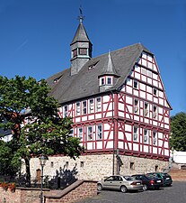
Town hall from 1539
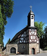
Cemetery chapel from 1583

City Church


Tree veterans and natural monuments
The Burglinden in Homberg
In the area of the old Homberg Castle on the Schloßberg, known as "Schloß Homberg", there are three remarkable old linden trees. One in front of the castle at the entrance to the castle gate, in the former kennel. Another inside the complex, directly in an inner courtyard wall of the castle courtyard, near the palace. The third is in the northeast corner, outside the fortification wall on the back of the site, on the path around the castle. Since the complex was not open to the public until it was taken over by the city, the two giant trees inside the castle and on the back remained largely unknown to the public. As a result, the term “the Burglinde” is used - generally refers to the outer linden tree in front of the gate that is visible to everyone.
- Linden tree in the kennel called "Burglinde"
(Natural monument) It is probably the oldest and most striking of the three linden trees. The mighty winter linden , which is included in the list of striking and old tree specimens , is believed to have been planted around 1600 and would therefore be 420 years old. Other estimates, however, even give it an age of up to 800 years. Its gnarled, partially hollow and multiply divided trunk has a circumference of 9.22 m.
- Linden tree in the courtyard
(Natural monument) The second of the three Burglinden stands in the middle of a wall inside the castle complex, in the castle courtyard west of the main building. This winter linden is also estimated to be 400–800 years old. Its mighty main trunk has a circumference of approx. 7.5 m. After about three to three and a half meters, it divides into several main branches that rise steeply upwards, which together reach a height of about 23 m and form an ostrich-shaped crown.
- Linden tree on the circular path
The third linden tree is again outside the castle on its back, directly opposite a door that leads outside through the castle wall. Only separated from the castle by the circular path that was laid out around the castle wall, the tree grows on the edge of the slope. This linden tree, also a winter linden tree, gives the impression of having originally grown from several individual trunks or saplings. It is also divided into a number of steep main branches that, like the linden tree in the castle courtyard, form a mighty ostrich-shaped crown. Its trunk, which is broken in places and partially hollow, has a circumference of 7.05 m. The age of this linden tree is estimated to be around 400 years. It was also determined to be worthy of protection, but it has apparently not yet been designated as a natural monument .
Striking examples in other parts of the city
- Pig oak near Büßfeld with a chest height circumference of 6.82 m (2014). The striking tree continues to grow - and very quickly. In a new measurement in March 2020, it had already reached a circumference of 7.02 m
- Linden tree at the old sheep trough near Nieder-Ofleiden
- Old church linden tree in ceiling stream
for more natural monuments of the city and its districts - see: List of natural monuments in Homberg (Ohm)
Economy and Infrastructure
Land use
The municipal area covers a total area of 8802 hectares, of which in hectares are:
| Type of use | 2011 | 2015 | |
|---|---|---|---|
| Building and open space | 368 | 373 | |
| from that | Living | 184 | 183 |
| Business | 43 | 46 | |
| Operating area | 78 | 78 | |
| from that | Mining land | 60 | 60 |
| Recreation area | 25th | 33 | |
| from that | Green area | 9 | 16 |
| traffic area | 459 | 459 | |
| Agricultural area | 4793 | 4778 | |
| from that | moor | 0 | 0 |
| pagan | 0 | 0 | |
| Forest area | 2642 | 2946 | |
| Water surface | 86 | 86 | |
| Other use | 50 | 49 | |
Established businesses
In 1955 a large factory was built by the screw manufacturer Kamax from Osterode am Harz in Homberg. In the Nieder-Ofleiden district, the Central German hard stone industry operates the “Hochberg” basalt quarry. The household goods manufacturer VEMMiNA is located in the Büßfeld district.
traffic
The Homberg (Ohm) junction of federal motorway 5 is about ten kilometers south of the city center. Federal highway 62 runs eight kilometers to the northeast .
The last plans are currently underway for the completion of the A 49 , which will then be connected to the federal motorway 5 near Maulbach . The expansion of this Herrenwaldtrasse is politically controversial, as there would also have been good reasons to connect the federal autobahn 49 to the A5 via Kirchhain and Marburg.
Homberg is in the area of the Rhein-Main-Verkehrsverbund . The RMV regional bus route 382 connects Homberg with the nearest train stations, Burg- and Nieder-Gemünden on the Vogelsbergbahn and Kirchhain on the Main-Weser-Bahn . The VB-71 line of the Oberhessen transport company also goes to Gemünden ; the VGO line VB-13 provides a connection to Alsfeld train station . The bus line MR-80 of the transport company ALV-Oberhessen offers a connection to Marburg . The VGO line VB-81 also runs within the city .
The Ohm Valley Railway Burg- und Nieder-Gemünden-Kirchhain, which runs through Homberg, is only in operation in the section from Nieder-Ofleiden , and there only for freight traffic ( basalt quarry "Hochberg" ).
The Hessian long-distance cycle route R6 ( Diemelstadt - Lampertheim ) also leads through Homberg.
education
Homberg has a primary school with a speech therapy class and childcare facilities. There is also an additive comprehensive school in the city with the Ohmtalschule.
There is also an AOK education center in Ober-Ofleiden .
Personalities
sons and daughters of the town
- Johannes Winckelmann (* 1551 in Homberg (Ohm); † August 13, 1626 in Gießen), Lutheran theologian
- Carl Theodor Welcker (born March 29, 1790 in Homberg (Ohm), † March 10, 1869 in Neuenheim near Heidelberg ), scholar and liberal politician
- Franz Friedrich Königer (born September 30, 1814 in Homberg (Ohm), † October 12, 1885 in Darmstadt), judge and member of parliament
- Karl Hisserich (born November 30, 1926 in Homberg (Ohm), † October 21, 2011 in Marburg), SPD politician
- Julian Justus (born January 29, 1988 in Giessen), German marksman, Olympic participant London 2012 (air rifle)
Personalities associated with the city
- Lars Nieberg (born July 24, 1963 in Wittingen), show jumper, lives in the district of Wäldershausen
literature
- Eva-Maria Dickhaut: Homberg an der Ohm - Investigations into the constitution, administration, finances and demography of a Hessian territorial city. Elwert Verlag, 1993, ISBN 3-7708-0997-1
- Karl Wagner, Gustav Georg Lange, Johann Wolfgang Appell: The Grand Duchy of Hesse. Darmstadt 1849, vol. 2, p. 81 ff.
- Dieter Wolf : Medieval and early modern architectural and art monuments of the city of Homberg an der Ohm. In: Fred Schwind (ed.): Homberg an der Ohm. An Upper Hessian city from the beginning to the present. Thorbecke, Sigmaringen 1984, ISBN 3-7995-4073-3 , pp. 215-275, plates 4-21.
- Literature on Homberg in the Hessian Bibliography
Web links
- Homberg (Ohm), municipality, Vogelsbergkreis. Historical local dictionary for Hessen. In: Landesgeschichtliches Informationssystem Hessen (LAGIS).
- Homberg (Ohm), Vogelsberg district. Historical local dictionary for Hessen. In: Landesgeschichtliches Informationssystem Hessen (LAGIS).
- Information on the community of Homberg (Ohm). In: Hessisches Gemeindelexikon. HA Hessen Agentur GmbH , 2016.
Individual evidence
- ↑ Hessian State Statistical Office: Population status on December 31, 2019 (districts and urban districts as well as municipalities, population figures based on the 2011 census) ( help ).
- ↑ a b c d e Homberg (Ohm), Vogelsberg district. Historical local dictionary for Hessen. (As of October 16, 2018). In: Landesgeschichtliches Informationssystem Hessen (LAGIS).
- ^ A b Georg Wilhelm Justin Wagner : Statistical-topographical-historical description of the Grand Duchy of Hesse: Province of Upper Hesse . tape 3 . Carl Wilhelm Leske, Darmstadt August 1830, OCLC 312528126 , p. 127 f . ( Online at google books ).
- ↑ Müller's Large German Local Book. 7th edition, Wuppertal-Barmen 1938, p. 455.
- ↑ a b Federal Statistical Office (ed.): Historical municipality register for the Federal Republic of Germany. Name, border and key number changes in municipalities, counties and administrative districts from May 27, 1970 to December 31, 1982 . W. Kohlhammer GmbH, Stuttgart and Mainz 1983, ISBN 3-17-003263-1 , p. 346, 347 and 387 .
- ^ Michael Rademacher: German administrative history from the unification of the empire in 1871 to the reunification in 1990. State of Hesse. (Online material for the dissertation, Osnabrück 2006).
- ^ Grand Ducal Central Office for State Statistics (ed.): Contributions to the statistics of the Grand Duchy of Hesse . tape 13 . G. Jonghause's Hofbuchhandlung, Darmstadt 1872, DNB 013163434 , OCLC 162730471 , p. 12 ff . ( Online at google books ).
- ↑ The affiliation of the Homberg an der Ohm office based on maps from the Historical Atlas of Hessen : Hessen-Marburg 1567–1604 . , Hessen-Kassel and Hessen-Darmstadt 1604–1638 . and Hessen-Darmstadt 1567–1866 .
- ^ Grand Ducal Central Office for State Statistics (ed.): Contributions to the statistics of the Grand Duchy of Hesse . tape 13 . G. Jonghause's Hofbuchhandlung, Darmstadt 1872, DNB 013163434 , OCLC 162730471 , p. 13 ff ., § 26 point d) III. ( Online at google books ).
- ↑ Wilhelm von der Nahmer: Handbuch des Rheinischen Particular-Rechts: Development of the territorial and constitutional relations of the German states on both banks of the Rhine: from the first beginning of the French Revolution up to the most recent times . tape 3 . Sauerländer, Frankfurt am Main 1832, OCLC 165696316 , p. 8 ( online at google books ).
- ↑ Latest countries and ethnology. A geographical reader for all stands. Kur-Hessen, Hessen-Darmstadt and the free cities. tape 22 . Weimar 1821, p. 419 ( online at Google Books ).
- ^ Georg W. Wagner: Statistical-topographical-historical description of the Grand Duchy of Hesse: Province of Upper Hesse . tape 3 . Carl Wilhelm Leske, Darmstadt 1830, p. 143 ff . ( online at Google Books ).
- ^ Ordinance on the implementation of the German Courts Constitution Act and the Introductory Act to the Courts Constitution Act of May 14, 1879 . In: Grand Duke of Hesse and the Rhine (ed.): Grand Ducal Hessian Government Gazette. 1879 no. 15 , p. 197–211 ( online at the information system of the Hessian state parliament [PDF; 17.8 MB ]).
- ↑ circular order by Reich Minister of Justice of 20 May 1943 - 3200/7 - Ia 9 995 - Subject: simplify judicial organization.
- ↑ Decree of the Hessian Minister of Justice of May 24, 1948 - 3210/1 - Ia 1961 - Subject: Conversion of the branch district court Homberg (Upper Hesse). ( Law on measures in the field of court organization and court constitution of November 17, 1953. In: The Hessian Minister of Justice (Ed.): Law and Ordinance Gazette for the State of Hesse . 1953 No. 30 , p. 189–191 , Annexes 1. ( Online at the information system of the Hessian State Parliament [PDF; 1,3 MB ]). )
- ↑ Second law amending the Court Organization Act (Amends GVBl. II 210–16) of February 12, 1968 . In: The Hessian Minister of Justice (ed.): Law and Ordinance Gazette for the State of Hesse . 1968 No. 4 , p. 41–44 , Article 1, Paragraph 2 b) and Article 2, Paragraph 4 e) ( online at the information system of the Hessian State Parliament [PDF; 298 kB ]).
- ↑ Fifth Act to Amend the Court Organization Act of June 12, 1973 . In: The Hessian Minister of Justice (ed.): Law and Ordinance Gazette for the State of Hesse . 1973 No. 15 , p. 199–201 , Article 1, Point 10.33 ( Online at the information system of the Hessian State Parliament [PDF; 385 kB ]).
- ^ A b Population according to nationality groups: Homberg (Ohm), Stadt. In: Zensus2011. Bavarian State Office for Statistics , accessed in April 2020 .
- ^ Households by family: Homberg (Ohm), city. In: Zensus2011. Bavarian State Office for Statistics , accessed in April 2020 .
- ↑ Hessen-Darmstadt state and address calendar 1791 . In the publishing house of the Invaliden-Anstalt, Darmstadt 1791, p. 198 ff . ( Online in the HathiTrust digital library ).
- ↑ Hessen-Darmstadt state and address calendar 1800 . In the publishing house of the Invaliden-Anstalt, Darmstadt 1800, p. 215 ff . ( Online in the HathiTrust digital library ).
- ↑ Hessen-Darmstadt state and address calendar 1806 . In the publishing house of the Invaliden-Anstalt, Darmstadt 1806, p. 260 ff . ( Online in the HathiTrust digital library ).
- ↑ Housing spaces 1867 . In: Grossherzogliche Centralstelle für die Landesstatistik (Ed.): Contributions to the statistics of the Grand Duchy of Hesse . tape 13 . G. Jonghause's Hofbuchhandlung, Darmstadt 1877, DNB 013163434 , OCLC 162730484 , p. 117 ( online at google books ).
- ↑ Residential places 1875 . In: Grossherzogliche Centralstelle für die Landesstatistik (Ed.): Contributions to the statistics of the Grand Duchy of Hesse . tape 13 . G. Jonghause's Hofbuchhandlung, Darmstadt 1877, DNB 013163434 , OCLC 162730484 , p. 12 ( online at google books ).
- ↑ Municipal data sheet : Homberg (Ohm). (PDF; 222 kB) In: Hessisches Gemeindelexikon. HA Hessen Agency GmbH
- ^ Local elections 1972; Relevant population of the municipalities on August 4, 1972 . In: The Hessian Minister of the Interior (ed.): State Gazette for the State of Hesse. 1972 No. 33 , p. 1424 , point 1025 ( online at the information system of the Hessian state parliament [PDF; 5.9 MB ]).
- ↑ a b Hessian Statistical Information System In: Statistics.Hessen.
- ^ Religious affiliation : Homberg (Ohm), city. In: Zensus2011. Bavarian State Office for Statistics , accessed in April 2020 .
- ↑ Hessian State Statistical Office: direct elections in Homberg (Ohm)
- ↑ ( page no longer available , search in web archives: Oberhessische Zeitung )
- ^ Result of the municipal election on March 6, 2016. Hessian State Statistical Office, accessed in April 2016 .
- ^ Hessian State Statistical Office: Result of the municipal elections on March 27, 2011
- ^ Hessian State Statistical Office: Result of the municipal elections on March 26, 2006
- ↑ Stadler, Klemens, Deutsche Wappen, Volume 3, Bremen 1967, p. 51
- ↑ "Burglinde in Homberg / Ohm" in the tree register at www.baumkunde.de
- ^ "Winter lime tree 'Burglinde' near the castle, Homberg" in Monumental Trees at monumentaltrees.com
- ^ "Burglinde in Homberg" in "Monumental oaks and other tree species" by Rainer Lippert
- ↑ "Burglinde in Homberg, the second" in the tree register at www.baumkunde.de
- ↑ "Burglinde in Homberg, the third" in the tree register at www.baumkunde.de
- ↑ Natural monuments in Hesse. (pdf; 405 kB) Annex to Small inquiry from Abg. Ursula Hammann (BÜNDNIS 90 / DIE GRÜNEN) of April 15, 2011 regarding biotope network part 2 and answer from the Minister for the Environment, Energy, Agriculture and Consumer Protection . Hessischer Landtag, June 22, 2011, p. 102 , accessed on February 4, 2016 .
- ^ Entry in the directory of monumental oaks . Retrieved January 10, 2017
- ↑ "Saueiche bei Büssfeld" in the tree register at www.baumkunde.de
- ↑ "Two lime trees near Nieder-Ofleiden" in the tree register at www.baumkunde.de
- ^ "Linde in ceilingbach" in the tree register at www.baumkunde.de

Alsfeld | Drift Valley | Feldatal | Freiensteinau | Gemünden (Felda) | Grebenau | Grebenhain | Herbstein | Homberg (Ohm) | Kirtorf | Lauterbach | Lautertal (Vogelsberg) | Mosquito | Romrod | Slot | Bulkheads | Schwalmtal | Ulrichstein | Wartenberg
.png)
Appenrod | Bleidenrod | Büßfeld | Dannenrod | Ceiling stream | Erbenhausen | Gontershausen | Haarhausen | Höingen | Homberg | Maulbach | Nieder-Ofleiden | Ober-Ofleiden | Schadenbach