
Kirchhain
| coat of arms | Germany map | |
|---|---|---|
_COA.svg)
|
Coordinates: 50 ° 49 ' N , 8 ° 55' E |
|
| Basic data | ||
| State : | Hesse | |
| Administrative region : | to water | |
| County : | Marburg-Biedenkopf | |
| Height : | 208 m above sea level NHN | |
| Area : | 90.91 km 2 | |
| Residents: | 16,290 (Dec. 31, 2019) | |
| Population density : | 179 inhabitants per km 2 | |
| Postal code : | 35274 | |
| Area code : | 06422 | |
| License plate : | MR, BID | |
| Community key : | 06 5 34 011 | |
| City structure: | 13 boroughs | |
City administration address : |
Am Markt 6/8 35274 Kirchhain |
|
| Website : | ||
| Mayor : | Olaf Hausmann ( SPD ) | |
| Location of the town of Kirchhain in the Marburg-Biedenkopf district | ||
  |
||


Kirchhain is a town in the Marburg-Biedenkopf district in central Hesse . It is located on the Ohm , Wohra and Klein rivers .
geography
Geographical location
Kirchhain is located in central Hesse on the north (east) edge of the Amöneburg basin . The core city is about 12 km east of Marburg , northeast of the confluence of the Wohra into the Ohm , where the flood retention basin Kirchhain / Ohm extends to the west and south of Kirchhains to protect the localities on the river .
The highest elevation in the urban area is 380 m above sea level. NN high castle wood with a lookout tower in the north, at the summit of which there is also the district of the same name. The Burgholz is the most south-westerly branch of the Gilserberger Heights , which form the north of the Upper Hessian threshold and roof the Kellerwald to the south along the Rhine-Weser watershed . The northeasternmost district of Emsdorf is also located at about 300 m above sea level within this ridge, on the southern slopes of which the northeastern district of Langenstein (up to 270 m ) and the extreme north of Kirchhain-Stadt (up to about 280 m ) extend into Pull towards Kirchhainer Stadtwald .
To the northwest of the city center, beyond the Wohra and on the flanks of the southern castle forest , the districts of Himmelsberg and Sindersfeld are each around 280 m above sea level . This is also where the Rauschenberg state forest is located , to which the northern part of the forest near Burgholz (north of the city forest) also belongs.
East of the city center, the federal highway 454 leads in the direction of Stadtallendorf directly over the Neustädter Sattel , part of the Upper Hessian threshold , which rises comparatively gently.
The areas to the west and south of the city are characterized by the arable land and floodplain landscapes of the Amöneburg basin, which are only interrupted by the basalt cone of the Amöneburg , 3 km south of the Kirchhain town center. Here - in addition to large parts of the city center - all previously unlisted districts are located at heights of around 190 to 220 m , with the western districts being in the immediate vicinity of the Lahnberge , while the northern districts of Betziesdorf , Anzefahr and Stausebach with the (southern) Burgwald are adjacent.
Neighboring communities
| Cölbe | Rauschenberg | |
| Marburg |
.svg)
|
Stadtallendorf |
| Ebsdorfergrund | Amöneburg |
All neighboring communities belong to the Marburg-Biedenkopf district .
City structure

In addition to the core town of Kirchhain with around 8,300 inhabitants, a further 8,900 inhabitants are distributed across the twelve districts:
history

Even in prehistoric times, the current city of Kirchhain ran through many long-distance and connecting routes. Already since the early Neolithic Age , different settlement epochs can be found there almost continuously. The eponymous menhir from Langenstein is the outstanding testimony of this epoch. The height of the settlement development was in the younger Iron Age (5th century BC).
However, the first territorial formations did not emerge until the 12th century AD. In 1146 the settlement was first mentioned under the name "Werphloh". At the time, the region belonged to the Landgraviate of Thuringia and, from 1247, Hesse , while the neighboring Amöneburg and large parts of the surrounding area were owned by the Archbishops of Mainz . Since then, there have been repeated disputes between the Mainz and Hesse communities over sovereignty. From the 13th century onwards, the Landgraves of Hesse promoted the expansion of Kirchhain as a Hessian bulwark against the Amöneburg in Mainz in order to be able to control the region. From then on, Kirchhain developed into the economic center of the Amöneburg Basin . The town charter Kirchhain was probably before 1348, as the official city's founding year, however, only the 1352 is considered to lack of earlier documentary evidence.

Since the 15th century, the important trade routes " Lange Hessen " and Cologne-Leipziger-Handelsstrasse formed a road junction in Kirchhain and thus favored the further economic development of the city. During the Thirty Years' War , the good transport connections meant that Kirchhain was occupied several times, was temporarily the headquarters of various armies and thus suffered from the frequent billeting of troops. In 1636 about 12,000-14,000 soldiers were housed in and around the city. This was an enormous burden for the city's population of around 1,000 at the time. Caspar Preis also reports on the war in and around Kirchhain in his Stausebacher Ortschronik.
Kirchhain also suffered from the chaos of war during the Seven Years' War , here too the good traffic situation led the troops to the city again and again.
From 1807 to 1813 Kirchhain was the administrative seat of the canton Kirchhain in the Kingdom of Westphalia . On August 18, 1807, Emperor Napoleon I formed the Kingdom of Westphalia with the capital Kassel. It includes Hessen-Kassel, Braunschweig and Hanover as well as Prussian areas west of the Elbe. The city of Kirchhain therefore also belongs to the Kingdom of Westphalia. The following description is given: Kirchhain, city and canton capital, on the influence of the Wohra in the Ohm. It has 1 castle seat, 1 Lutheran and 1 Reformed church, with 403 houses and 1,977 people.
From 1821 on, Kirchhain was the district town of the newly created Kirchhain administrative district until it was merged with the Marburg district in 1932.
Of the Jewish population of Kirchhain, who lived in Kirchhain from the end of the 16th century, Elchanan Henle Kirchhain is the best known. His gravestone is preserved in the Jewish cemetery in Kirchhains.
Stumbling blocks
Starting in 2015/16, the first stumbling blocks in the city area are to be set in memory of the Jewish population and the victims of the Holocaust. This is mainly thanks to the commitment of some students and teachers from the Alfred Wegener School in Kirchhain.
Incorporations
On 1 February 1971 the framework of were municipal reform in Hesse , the previously independent municipalities Anzefahr, Betziesdorf, castle wood, Himmelberg, Kleinseelheim, coppice and Schönenbach as neighborhoods incorporated . On December 31, 1971 Langenstein, Sindersfeld and Stausebach were added. Emsdorf and Großseelheim followed by state law on July 1, 1974.
Territorial history and administration
The following list gives an overview of the territories in which Kirchhain was located and the administrative units to which it was subordinate:
- before 1567: Landgraviate of Hesse , Marburg Office , Kirchhain court (Kirchhain court consisted of the following places: Kirchhain, Langenstein and Niederwald)
- from 1567: Landgraviate of Hessen-Marburg , Marburg Office, Kirchhain Court
- from 1592: Landgraviate of Hessen-Marburg, Kirchhain office
- 1604–1648: disputed between Landgraviate Hessen-Darmstadt and Landgraviate Hessen-Kassel ( Hessenkrieg ), Office Kirchhain
- from 1648: Landgraviate of Hessen-Kassel, Kirchhain office
- from 1803: Landgraviate of Hessen-Kassel in the Electorate of Hessen , Kirchhain office
- 1807–1813: Kingdom of Westphalia , department of Werra , district of Marburg , canton of Kirchhain
- from 1815: Electorate of Hesse, Province of Upper Hesse , Kirchhain office
- from 1821: Electorate of Hesse, Province of Upper Hesse , District of Kirchhain (separation of justice ( Justice Office Kirchhain ) and administration)
- from 1848: Electorate of Hesse, Marburg district
- from 1851: Electorate of Hesse, Province of Upper Hesse, Kirchhain district
- from 1866: Kingdom of Prussia , Hesse-Nassau Province , Kassel District, Kirchhain District
- from 1871: German Empire , Kingdom of Prussia, Province of Hessen-Nassau, administrative district of Kassel, district of Kirchhain
- from 1918: German Empire, Free State of Prussia , Province of Hessen-Nassau, Administrative District of Kassel, District of Kirchhain
- from 1932: German Empire, Free State of Prussia, Province of Hessen-Nassau, Administrative District of Kassel, District of Marburg
- from 1944: German Empire, Free State of Prussia, Province of Kurhessen , District of Marburg
- from 1945: American zone of occupation , Greater Hesse , Kassel district, Marburg district
- from 1949: Federal Republic of Germany , State of Hesse , Kassel district, Marburg district
- 1974: Federal Republic of Germany, Land Hessen, Kassel , Marburg-Biedenkopf
- from 1981: Federal Republic of Germany, State of Hesse, Gießen district, Marburg-Biedenkopf district
Courts since 1821
With an edict of June 29, 1821, administration and justice were separated in Kurhessen. Now judicial offices were responsible for the first instance jurisdiction, the administration was taken over by the districts. In Kirchhain, the Kirchhain district was set up for the administration and the Kirchhain Justice Office was responsible as a court for Kirchhain. The Supreme Court was the Higher Appeal Court in Kassel . The higher court of Marburg was subordinate to the province of Upper Hesse. It was the second instance for the Kirchhain Justice Office.
After the annexation of Kurhessen by Prussia, the justice office became the royal Prussian district court in Kirchhain . In June 1867 a royal decree was issued that reorganized the court system in the former Duchy of Nassau and the parts of the area that had previously belonged to the Grand Duchy of Hesse. The previous judicial authorities were to be repealed and replaced by local courts in the first, district courts in the second and an appeal court in the third instance. In the course of this, on September 1, 1867, the previous judicial office was renamed the Kirchhain District Court. The courts of the higher authorities were the Marburg District Court and the Kassel Court of Appeal .
Even with the entry into force of the Courts Constitution Act of 1879, the district court remained under his name. In the Federal Republic of Germany, the superordinate instances are the Marburg Regional Court , the Frankfurt am Main Higher Regional Court and the Federal Court of Justice as the last instance.
population
Population development
Source: Historical local dictionary
| • 1577: | 251 house seats , including 6 castle seats |
| • 1592: | 240 house seats |
| • 1612: | 258 plague deaths |
| • 1629: | 249 households |
| • 1681: | 190 home-seated teams |
| • 1747: | 286 households |
| • 1838: | 337 residents who are entitled to use, 21 residents who are not entitled to use, 19 residents . |
| Kirchhain: Population from 1786 to 2015 | ||||
|---|---|---|---|---|
| year | Residents | |||
| 1786 | 1,528 | |||
| 1834 | 1,844 | |||
| 1840 | 1,788 | |||
| 1846 | 1,859 | |||
| 1852 | 1,843 | |||
| 1858 | 1,721 | |||
| 1864 | 1,660 | |||
| 1871 | 1,693 | |||
| 1875 | 1,684 | |||
| 1885 | 1,796 | |||
| 1895 | 1,958 | |||
| 1905 | 2,340 | |||
| 1910 | 2,421 | |||
| 1925 | 2,648 | |||
| 1939 | 3,049 | |||
| 1946 | 4,284 | |||
| 1950 | 4,559 | |||
| 1956 | 4,789 | |||
| 1961 | 5,524 | |||
| 1967 | 6,634 | |||
| 1972 | 12,467 | |||
| 1976 | 15,128 | |||
| 1984 | 15,443 | |||
| 1992 | 15,697 | |||
| 2000 | 16,300 | |||
| 2010 | 16,243 | |||
| 2015 | 16,300 | |||
| Data source: Historical municipality register for Hesse: The population of the municipalities from 1834 to 1967. Wiesbaden: Hessisches Statistisches Landesamt, 1968. Further sources:; 1972 :; 1976 :; 1984 :; 1992 :; 2000, 2015 :; 2010: From 1972 including the towns incorporated into Hesse as part of the regional reform . | ||||
Religious affiliation
Source: Historical local dictionary
| • 1861: | 440 Evangelical Reformed , 1198 Evangelical Lutheran , 1 United, 59 Roman Catholic, 49 Jewish residents |
| • 1885: | 1554 Protestant, 101 Catholic and 141 Jewish inhabitants |
| • 1961: | 4065 Protestant , 1336 Roman Catholic residents |
Gainful employment
Source: Historical local dictionary
| • 1786: | 60 bakers, 18 tailors, 58 shoemakers, 17 linen weavers, 10 butchers, 16 tanners, 5 blacksmiths, 6 locksmiths, 1 wagner, 2 benders, 6 shopkeepers, 3 saddlers, 1 Eulner or brickmaker, 3 hatmakers, 4 carpenters, 1 wood turner, 3 window makers, 2 stocking weavers, 4 woolen stocking knitters, 4 carpenters, 4 bricklayers and white binders, 6 innkeepers, 3 wine tellers, 27 brandy burners and brewers, 3 soap makers, 1 furrier, 24 beer brewers, 1 master brewer, 2 brewmen, 4 leather traders, 4 surgeons, 1 pharmacist, 5 shepherds, 39 day laborers; 6 Jews who do business with cattle, currency exchange and other things. |
| • 1838: | Families: 63 agriculture, 200 businesses, 48 day laborers. |
| • 1961: | Labor force: 158 agriculture and forestry, 1138 manufacturing, 536 trade and transport, 578 services and other. |
politics
City Council
The local elections on March 6, 2016 produced the following results, compared to previous local elections:
| Parties and constituencies |
% 2016 |
Seats 2016 |
% 2011 |
Seats 2011 |
% 2006 |
Seats 2006 |
% 2001 |
Seats 2001 |
||
|---|---|---|---|---|---|---|---|---|---|---|
| CDU | Christian Democratic Union of Germany | 36.2 | 13 | 39.9 | 15th | 40.6 | 15th | 39.3 | 15th | |
| SPD | Social Democratic Party of Germany | 46.1 | 17th | 38.8 | 14th | 40.3 | 15th | 47.1 | 17th | |
| GREEN | Alliance 90 / The Greens | 7.7 | 3 | 14.6 | 5 | 9.6 | 4th | 7.4 | 3 | |
| FDP | Free Democratic Party | 5.1 | 2 | 3.8 | 2 | 5.7 | 2 | - | - | |
| THE LEFT | The left | 4.9 | 2 | 2.8 | 1 | - | - | - | - | |
| UWG | Independent voter community | - | - | - | - | 3.9 | 1 | 6.2 | 2 | |
| total | 100.0 | 37 | 100.0 | 37 | 100.0 | 37 | 100.0 | 37 | ||
| Voter turnout in% | 57.7 | 50.5 | 53.6 | 60.5 | ||||||


mayor
According to the Hessian municipal constitution, the mayor is the chairman of the magistrate , which in the town of Kirchhain includes eight voluntary councilors in addition to the mayor . As of August 1, 2016, Olaf Hausmann (SPD) is the mayor. His directly elected predecessors were
- 2004 to 2016 Jochen Kirchner
- 1998 to 2004 Klaus Hesse (SPD)
coat of arms
On November 11, 1986, the Hessian Ministry of the Interior gave the city permission to use the coat of arms described below.
Blazon : "In red a silver spangenhelm with golden helmet covers and two silver buffalo horns as a helmet ornament, each decorated with six silver linden twigs, a golden 'K' between the buffalo horns."
The city coat of arms was designed by the heraldist Heinz Ritt from Bad Nauheim.
Town twinning
- Plomelin , France, Brittany (since 1966, founded and lived in what is now the Betziesdorf district )
- Doberlug-Kirchhain , Brandenburg (since 1989)
Culture and sights
Markets
Thanks to its location on the old trade routes, Kirchhain is a traditional market town. Many markets are held in Kirchhain to this day. The largest markets with tens of thousands of visitors are the Easter market on the weekend before Easter and the Martinsmarkt, which is held on the last weekend in October. On the first weekend in Advent, the Kirchhain art market takes place together with the Christmas market; the New Year's market is held on the last working day before New Year's Eve.
Parks and green spaces
.jpg)
Annapark is located on the north-western edge of Kirchhain's old town, a former (1828 to 1899) cemetery, which was prepared as a park by the Marburg brewery owner Bopp and named after his wife. In addition to the sculpture “Die Waiting” (by Hermann Pohl, Kassel), the bronze sculpture Lesendes Mädchen (nickname “Anneliese”) by the Münsterland sculptor Bernhard Kleinhans has been located there since June 2015 . His widow, a native of Kirchhain, donated it to the city.
Natural spaces
The Erlensee nature discovery area is located near the core town of Kirchhains. Some areas of it belong to the nature reserve Brießelserlen. This is a popular bird retreat. In addition, the Erlensee also offers some attractions for walkers and nature lovers. There is an information and acoustic station where animal voices and sound images can be heard, a tree-of-the-year path, where all trees of the year chosen since 1989 can be admired as planted specimens, an observation platform and a seasonal path on the respective one Seasonal display boards with information about Erlensee and the local flora and fauna are hung up. Furthermore, the Erlensee sees itself as an extracurricular learning location where guided tours are offered all year round on request. A guidance and guidance system was built around the lake for the blind.
In the Kirchhain district of Himmelsberg there is an old summer linden tree that used to function as a dancing linden tree , the so-called Linden zu Himmelsberg . It is also known as the 1000-year-old linden tree and has been a natural monument since 1971. 2001 their motive appeared on a special brand of Deutsche Post .
Museums
The small roof museum in the club rooms of the Kurhessische Bürgergarde Kirchhain eV (Bahnhofstraße) houses a local and military history collection on the history of Kirchhain.
The history of Großseelheim is presented in the Großseelheim Local History Museum. A fully equipped blacksmith's shop and a shoemaker's workshop can be visited in the museum.
Buildings
- Core city
In the core town of Kirchhains there is a so-called old town area or historical town center with some interesting buildings that have been preserved. These include the half-timbered town hall, built around 1450, and the “Zum Blaue Löwen” house, built in 1612. The former is considered the landmark of the town of Kirchhain and is located on the edge of the market square. The second is the house where the poet Eberhard Werner Happel was born . In addition, the remains of the city wall with the witch's tower, where women used to be imprisoned as "witches" before they came to Marburg for judgment and the castle gate, which is now part of the construction of an old people's and nursing home, are worth seeing as part of the former city castle. In addition, the city center is worth a visit to the Evangelical Church of St. Michael from the 15th century and the torso of the former synagogue .

The sculpture trail has existed since 2006, taking up the connection between people and nature as a central theme. It stretches for about two kilometers and runs from Erlensee via Annapark to the train station. Since its inauguration as part of the cultural autumn of the Burgwald region, the path has been expanded to include additional exhibits. The “open-air collection” now includes sculptures and sculptures by domestic and internationally renowned artists. Including z. B. the sculptures Geloest (by Ortrud Sturm ), Plenty of Graces (by Werner Berges ) or the large sculpture La Goutte (by Luigi Colani ).
In Anzefahr, the Semme Cross, the baroque Catholic parish church of St. Michael and the buildings of the Ordensmühle an der Ohm are among the most important historical evidence. In addition, a memorial stone reminds of the excavations in the upper part of the Kiefernweg. Several urn graves were uncovered during the excavations. However, they are no longer seen these days.
The late Baroque parish church , built in 1789, is the landmark of the district .
To the west of the district you can see some remains of the Hunburg . They were uncovered during excavations in 1936. In addition, the Katharinenbrunnen has also been preserved. He first supplied the castle with water and then later the Burgholz citizens. The restored syringe house is a gem in Burgholz.
The Catholic church Mariae Himmelfahrt in Emsdorf was built in baroque style and is one of the most beautiful baroque churches in Upper Hesse. Its altars and ceiling paintings are particularly worth seeing.
With the Protestant St. Jakobi Church, Langenstein owns one of two churches in Germany that have a so-called double free-floating hexagonal honeycomb network vault. It is therefore an outstanding cultural monument. The Lange Stein is also worth seeing. It is one of the most important menhirs in Hesse, if not Germany.
The sights of the district include the Church of St. Matthew and the Atonement Cross. The church is one of the few art nouveau churches in the region.
The largest attraction in the district is the late Gothic church of St. Mariae Himmelfahrt. Around the church are some old tombstones from the 17th century and younger. There are also some partially reconstructed Bronze Age barrows north of Stausebach.

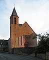
The St. Elisabeth Church

The "Blue Lion"

City church St. Michael and Gillhof

Hexenturm with part of the city wall


.jpg)

Economy and Infrastructure
education
With over 1000 students, the Alfred Wegener School is the largest school in the city and is located northwest of the city center. It includes two school sports halls and a stadium . Directly adjacent are the vocational schools and a large sports hall (Heinrich-Weber-Halle), which is operated by the Marburg-Biedenkopf district . In addition, there is a primary school in the city center as well as in most parts of the city.
Economic structure
The Kirchhain train station is located in the city center . From the station forecourt, the Kirchhain pedestrian zone, a shopping street with numerous retail stores, including department stores, boutiques , electronics stores and restaurants, runs south to the market square . There is a large new building area in the direction of Emsdorf; In addition to a large number of newly built single and multi-family houses, there is also a new building for the elderly care center and the curative educational community.
The areas at the eastern and western end of the city are designated as industrial areas, with the Kirchhain industrial park being the larger of the two. The two largest manufacturing companies are the Marburger wallpaper factory and the solar system manufacturer Wagner & Co , which opened the first energy-neutral factory for the largely automated production of solar collectors in Kirchhain in 2008.
traffic

Kirchhain is connected to the B 62 expressway and the B 454 via the Kirchhain-West, Kirchhain-Mitte and Kirchhain-Ost junctions and is thus connected to the federal trunk road network.
From the bus station at Kirchhain train station, there are numerous bus connections within Kirchhain, to all parts of the city, as well as to many surrounding cities, such as Marburg .
There are train connections from Kirchhain station via the Main-Weser-Bahn in the direction of Frankfurt and Kassel. The Main-Weser-Express , the Kassel wing train of the Main-Sieg-Express and the Mittelhessen-Express stop in Kirchhain . The station building dates from 1849 and was designed by Julius Eugen Ruhl .
Public facilities
The district court of Kirchhain has its seat in the city.
Personalities
Personalities born in Kirchhain

- Heinrich von Langenstein (1325–1397), theologian, church politician and astronomer
- Heinrich Kornmann (1570–1627), lawyer, Electorate Mainz councilor and chronicler
- Katharina Lips (around 1625 - unknown), executed in 1672 as an alleged witch in a witch trial
- Eberhard Werner Happel (1647–1690), poet
- Hennoch Wolf alias Elchanan Henle Kirchhain (1666–1757), rabbi and author of the Yiddish moral book Simchat ha-Nefesch
- Johann Heinrich Fenner von Fenneberg (1774–1849), medic and poet
- Heinrich Joseph Wetzer (1801-1853), orientalist
- Heinrich Scheffer (1808–1846), writer, mayor of Kirchhain
- Benedict Stilling (1810–1879), physician and anatomist
- Ludwig Happich (1858-after 1929), Reich judge
- Paul Heinrich Römer (1876–1916), hygienist, only student of Emil von Behring, full professor in Greifswald and Halle
- Moritz Rülf (1888-probably 1942), teacher and Jewish preacher
- Lisa de Boor b. Hüttel (1894–1957), poet, writer
- Albert Henze (1894–1979), Lieutenant General in World War II
- Leo Strauss (1899–1973), philosopher
- Otto Schweinsberger (1904 – after 1958), lawyer
- Ursula de Boor (1915–2001), member of the White Rose Hamburg, a resistance group against National Socialism
- Clemens de Boor (1920–2005), head of the Sigmund Freud Institute in Frankfurt am Main
- Fritz Cron (1925–2017), motorcycle carriage racing driver, world champion in 1954 and 1956
- Wilhelm Noll (1926–2017), motorcycle carriage racing driver, world champion in 1954 and 1956
- Almut Seiler-Dietrich (* 1947), author
- Felix Römer (* 1979), author and slam poet
Personalities who lived or worked in Kirchhain
- Heinrich Horch (1652–1729), separatist mystic within radical pietism, lived in Kirchhain from 1708 until his death
- Friedrich Cranz (1792–1840), administrative officer and former district administrator in the Kirchhain district, died in Kirchhain
- Ludwig Vogel (1920–2014), Roman Catholic priest, chaplain in Kirchhain-Anzefahr
- Mathias Schröder (* 1941), doctor, writer and screenwriter, grew up in Kirchhain
- Friedrich Bohl (* 1945), politician (CDU), from 1991 to 1998 Federal Minister for Special Tasks head of the Federal Chancellery, resident in Kirchhain
- Werner Meuser (* 1952), world champion in gliding, lives in Kirchhain
- Reiner Cunz (* 1958), historian and numismatist, grew up in Kirchhain
- Andreas Blank (1961–2001), Romance studies and linguist, died in Kirchhain
- Gabriela Lesch (* 1964), middle-distance runner, lives in Kirchhain
- Maximilian Schwetz (* 1991) former professional triathlete
literature
- Hermann Dippel, Paul Koch: Kirchhain then and now . Marburg 2001, ISBN 3-89445-282-X .
- Heinrich Grün: Chronicle of the city of Kirchhain. Kirchhain 1952.
- WG Soldan, H. Heppe: History of the witch trials . Volume 2, ed. by Max Bauer, Hanau / Main, reprint of the 3rd edition from 1911, pp. 96–98.
- Georg Hassel, Geographical Statistical Outline of the Kingdom of Holland, published by the publishing house of the country, Weimar 1809, p. 491
- Brigitte Beier, Neue Chronik der Weltgeschichte, Chronik Verlag 2007, p. 483
- Literature about Kirchhain in the Hessian Bibliography
Web links
- Kirchhain, municipality, Marburg-Biedenkopf district. Historical local dictionary for Hessen. In: Landesgeschichtliches Informationssystem Hessen (LAGIS).
- Kirchhain, Marburg-Biedenkopf district. Historical local dictionary for Hessen. In: Landesgeschichtliches Informationssystem Hessen (LAGIS).
- Information on the community of Kirchhain. In: Hessisches Gemeindelexikon. HA Hessen Agentur GmbH , 2016.
- Illustration by Daniel Meisner from 1626: Kirchain. Depressed but not crushed. ( Digitized version )
Individual evidence
- ↑ Hessian State Statistical Office: Population status on December 31, 2019 (districts and urban districts as well as municipalities, population figures based on the 2011 census) ( help ).
- ↑ Brigitte Beier, Neue Chronik der Weltgeschichte, Chronik Verlag 2007, p. 483
- ↑ Georg Hassel, Geographical and Statistical Outline of the Kingdom of Holland, published by the Land Publishers, Weimar 1809, p. 491
- ^ Municipal reform: mergers and integration of municipalities from January 20, 1971 . In: The Hessian Minister of the Interior (ed.): State Gazette for the State of Hesse. 1971 No. 6 , p. 248 , point 328, paragraph 54 ( online at the information system of the Hessian state parliament [PDF; 6.2 MB ]).
- ↑ Law on the reorganization of the Biedenkopf and Marburg districts and the city of Marburg (Lahn) (GVBl. II 330-27) of March 12, 1974 . In: The Hessian Minister of the Interior (ed.): Law and Ordinance Gazette for the State of Hesse . 1974 No. 9 , p. 154 , § 7 ( online at the information system of the Hessian state parliament [PDF; 3.0 MB ]).
- ^ Federal Statistical Office (ed.): Historical municipality directory for the Federal Republic of Germany. Name, border and key number changes in municipalities, counties and administrative districts from May 27, 1970 to December 31, 1982 . W. Kohlhammer, Stuttgart / Mainz 1983, ISBN 3-17-003263-1 , p. 402 and 404 .
- ↑ a b c d e Kirchhain, Marburg-Biedenkopf district. Historical local dictionary for Hessen. (As of May 25, 2018). In: Landesgeschichtliches Informationssystem Hessen (LAGIS).
- ^ Michael Rademacher: German administrative history from the unification of the empire in 1871 to the reunification in 1990. State of Hesse. (Online material for the dissertation, Osnabrück 2006).
- ^ Georg Landau: Description of the Electorate of Hesse . T. Fischer, Kassel 1842, p. 413 ( online at HathiTrust's digital library ).
- ^ Kur-Hessischer Staats- und Adress-Kalender: 1818 . Publishing house d. Orphanage, Kassel 1818, p. 115 ( online at Google Books ).
- ↑ Ordinance of August 30th, 1821, concerning the new division of the area , Annex: Overview of the new division of the Electorate of Hesse according to provinces, districts and judicial districts. Collection of laws etc. for the Electoral Hesse states. Year 1821 - No. XV. - August, ( kurhess GS 1821) pp. 223-224 .
- ↑ Latest news from Meklenburg / Kur-Hessen, Hessen-Darmstadt and the free cities, edited from the best sources. in the publishing house of the GHG privil. Landes-Industrie-Comptouts., Weimar 1823, p. 158 ff . ( online at HathiTrust's digital library ).
- ↑ Ordinance on the constitution of the courts in the former Duchy of Nassau and the former Grand Ducal Hessian territories excluding the Meisenheim district of June 26, 1867. ( PrGS 1867, pp. 1094–1103 )
- ↑ Order of August 7, 1867, regarding the establishment of the according to the Most High Ordinance of June 26th J. in the former Duchy of Nassau and the former Grand Ducal Hessian territories, with the exclusion of the Oberamtsbezirks Meisenheim, courts to be formed ( Pr. JMBl. Pp. 218-220 )
- ^ Local elections 1972; Relevant population of the municipalities on August 4, 1972 . In: The Hessian Minister of the Interior (ed.): State Gazette for the State of Hesse. 1972 No. 33 , p. 1424 , point 1025 ( online at the information system of the Hessian state parliament [PDF; 5.9 MB ]).
- ↑ Local elections 1977; Relevant population figures for the municipalities as of December 15, 1976 . In: The Hessian Minister of the Interior (ed.): State Gazette for the State of Hesse. 1976 No. 52 , p. 2283 , point 1668 ( online at the information system of the Hessian state parliament [PDF; 10.3 MB ]).
- ^ Local elections 1985; Relevant population of the municipalities as of October 30, 1984 . In: The Hessian Minister of the Interior (ed.): State Gazette for the State of Hesse. 1984 No. 46 , p. 2175 , point 1104 ( online at the information system of the Hessian state parliament [PDF; 5.5 MB ]).
- ↑ local elections 1993; Relevant population of the municipalities as of October 21, 1992 . In: The Hessian Minister of the Interior (ed.): State Gazette for the State of Hesse. 1992 No. 44 , p. 2766 , point 935 ( online at the information system of the Hessian state parliament [PDF; 6.1 MB ]).
- ^ Community data sheet : Kirchhain. (PDF; 222 kB) In: Hessisches Gemeindelexikon. HA Hessen Agency GmbH
- ↑ The population of the Hessian municipalities on June 30, 2010. (PDF; 552 kB) (No longer available online.) Hessisches Statistisches Landesamt, p. 11 , archived from the original on February 7, 2018 ; accessed on March 20, 2018 .
- ^ Result of the municipal election on March 6, 2016. Hessian State Statistical Office, accessed in April 2016 .
- ^ Hessian State Statistical Office: Result of the municipal elections on March 27, 2011
- ^ Hessian State Statistical Office: Result of the municipal elections on March 26, 2006
- ↑ Hessian State Statistical Office: Direct elections in Kirchhain ( Memento from March 24, 2016 in the Internet Archive )
- ↑ Olaf Hausmann on the Internet on his inauguration , accessed on July 28, 2016.
- ^ City of Kirchhain: Markets in Kirchhain , accessed on August 15, 2017
- ↑ a b Irmgard Bott: "Discovering art and nature" - Flyer on the Kirchhain sculpture trail. (PDF) City Council of Kirchhain, accessed on July 19, 2017 .
- ↑ Anneliese joins Anna in Anna-Park ( Memento from July 6, 2015 in the Internet Archive )
- ^ The Kurhessische Bürgergarde Kirchhain e. V. accessed in August 2017
- ↑ Heimatmuseum Großseelheim accessed in August 2017
- ↑ City of Kirchhain: For our guests , accessed in August 2017.
- ↑ Marburg City and Country: Historic Old Town Kirchhain , accessed in August 2017.
- ↑ Kerstin Ebert: The Kirchhain sculpture trail - discovering art and nature. (PDF; 587 kB) Kirchhain city administration, accessed on July 19, 2017 .
- ↑ Chronicle of the community of Anzefahr , accessed in August 2017.
- ↑ Our Burgholz: Sights , accessed in August 2017.
- ↑ The Church of the Assumption of Mary in Emsdorf , accessed in August 2017.
- ^ Siegfried Lohr : Planning and buildings by the Kassel master builder Julius Eugen Ruhl 1796–1871. A contribution to the building history of Kassel and Kurhessen in the 19th century . Masch. Diss. Darmstadt [1982], p. 352.
- ↑ a b c Stadt Kirchhain: Significant Kirchhainers , accessed in August 2017.
- ^ Research Center for Culture Impulse: Biography Lisa de Boor , accessed in August 2017.
- ^ Munzinger archive: biography of Friedrich Bohl , accessed in August 2017.

Amöneburg | Fishing castle | Bad Endbach | Biedenkopf | Breidenbach | Cölbe | Dautphetal | Ebsdorfergrund | Fronhausen | Gladenbach | Kirchhain | Lahn valley | Lohra | Marburg | Munchausen | Neustadt (Hessen) | Rauschenberg | Stadtallendorf | Steffenberg | Weimar (Lahn) | Weather (Hessen) | Wohratal
Anzefahr | Betziesdorf | Burgholz | Emsdorf | Großseelheim | Himmelsberg | Kleinseelheim | Langenstein | Niederwald | Schönbach | Sindersfeld | Reservoir stream