
Amöneburg (mountain)
| Amöneburg | ||
|---|---|---|
 View from the west, Wenigenberg on the right. |
||
| height | 365 m above sea level NHN | |
| location | Amöneburg , Marburg-Biedenkopf district , Hesse | |
| Mountains | Inselberg | |
| Dominance | 6.6 km → Vorderer Vogelsberg | |
| Notch height | 157 m ↓ near junction Kleinseelheim from the L 3048 (to the Lahnberge ) | |
| Coordinates | 50 ° 47 '48 " N , 8 ° 55' 18" E | |
|
||
| rock | basalt | |
| particularities | Amöneburg Castle | |
.jpg) View from the southeast with lower and upper town |
||

The Amöneburg is an approximately 365 m high basalt cone (truncated) and singularity of the otherwise flat- wavy Amöneburg Basin named after it in the east of the Marburg-Biedenkopf district , Central Hesse . The old town of Amöneburg is on its summit , and the rest of the city center is on its southeastern slope and foot. While only a small part of the approximately 1500 inhabitants of the city center live on the summit plateau, 800 pupils are taught by around 70 teachers at the St. Johann Abbey School there. Amöneburg Castle and the parish church of St. John the Baptist are located directly in the summit area . The Amöneburg nature reserve stretches in a ring around the old town and from there south to Wenigenburg (317 m) .
location
The Amöneburg is located in the urban area of the same name about 2.7 km south of the city center of Kirchhain and about 11 km east-southeast of Marburg . 2.7 km west-north-west is Kleinseelheim (to Kirchhain), the districts of Roßdorf (south-south-west) and Mardorf (south) are around 3.5 km away, the district of Rüdigheim is 2.8 km south-east; the Brücker Mühle is only 1.1 km south-southeast of the summit and around 170 m lower on the Ohm .
Dominance and prominence
The Amöneburg is by far the most striking mountain, but the edge ridges of the Amöneburg basin are all a bit higher. The dominance of the mountain is about 6.6 km; at this distance to the south, its height is exceeded on the Vorderen Vogelsberg , on the northern foothills of the Mardorfer Kuppe (406.8 m). To the north, however, you have to distance yourself around 8.2 km to exceed this height at Burgholz (379 m) in the southwest of the Gilserberger Heights , the dominance to the west is similar to the Lahn Mountains (up to a good 380 m).
The prominence of Amoeneburg is approximately 157 m, the notch on the way to Sennenberg (383 m) in the front Vogelsberg or stamp (365.4 m) and sparse Küppel (368.3 m) in the southern Lahnbergen is located close to the branch Kleinseelheim from Landesstraße 3048 Roßdorf - Kirchhain at around 208 m.
geology

The Amöneburg is considered to be the most north-westerly geomorphologically emerging branch of the Vogelsberg volcanism. The basaltoide rock of Amöneburg represents the feed chimney of a deeply eroded , miozänzeitlichen volcano. Sometimes there are tuffs in the chimney filling, which suggests that the “Amöneburg volcano” had an explosive character at least now and then . The most recent deposits through the chimney can be found in the area around the mountain. These are clays , silts and sand ( stones ) from the Tertiary Hessian Depression, which were deposited in the period from the Upper Eocene ( Priabonian ) to the Lower Oligocene ( Rupelian ). However, these deposits are mostly covered by several meters thick Pleistocene loess . The Tertiary and not infrequently also the Quaternary, in turn, store layers of red sandstone (drilled at a depth of at least 10 meters), which emerge over large areas further west and north in the Lahn Mountains and the Burgwald .
Numerous outcrops of the basaltoid volcanic rock can be found on the often steep slopes . The basalt columns on Bilstein on the eastern slope are particularly striking and rich in shapes.
Nature reserve
The Amöneburg nature reserve was designated as early as June 16, 1927 and, according to the city of Amöneburg, is the oldest nature reserve in Hesse, but the Devil's Hole and Almosenwiese NSG near Steinau an der Strasse in the Main-Kinzig district is a good three years older.
The NSG originally had an area of 27 ha and was in two parts, today it is only slightly larger and contiguous with 32.09 ha, but not simply contiguous , as the unprotected old town makes it a ring from which a clear nose can be seen South to Wenigenburg is enough. The green areas have been grazed extensively with goats since 2008 in order to achieve a typical grassland flora, which particularly promotes rare butterfly species.
Rare plants include small-flowered rose (see dog roses ), striped and hare clover , bristle feather fescue (see fescue ), callous dandelion (see dandelion ), centaury , heather carnation and nodular saxifrage , common Feltwort , silver cinquefoil , egret's bill and adder's head .
Rare insects in the NSG are in particular the butterflies swallowtail , golden eight , wall fox , small cube-headed butterflies and matt-piebald brown-thick-headed butterflies, as well as the western bite . Of rare birds in particular find partridge , turncoat , gray-headed woodpecker , Eurasian Hobby , Red Kite , Little Owl , Barn Owl , Red-backed Shrike and wheatear .
Currently (2020) there are still numerous locust trees in the area of the NSG, some of which were planted as avenue trees on the circular path. Since they are actually not native, their rejuvenation is prevented by hand with root cuttings and seedlings.
Infrastructure
The district road 30 leads from the section-wise motorway-like federal road 62 Marburg - Kirchhain in the north directly on the mountain and on the south-east side in the direction of Brücker Mühle again, where z. B. the road towards Homberg (Ohm) can be reached. However, it leads through relatively narrow streets in the old town, which is why the regular 13 buses that cart the students to the collegiate school and back, in precisely coordinated shifts of 3 buses each, only come from the north and drive a loop through the old town and head north remove again.
To the north, directly in front of the city wall, there are parking spaces on the "Kuhberg" on a hillside, from which you can hike around the mountain. The festival meadow west of the castle ruins is regularly released for parking on parent school days.
view
The Amöneburg offers a wide view in all directions, but there is no point with a 360 ° or even 180 ° all-round view. When hiking around the summit in a counterclockwise direction, starting in the north, the following stand out in particular (see Udeuschle under #Weblinks ):
|
|
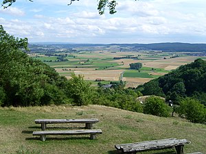
Vogelsberg and Mardorfer Kuppe
Basaltw. N. Ofleiden , Erfurtshsn. , Mardorf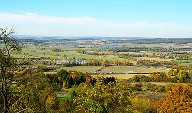
Kohlberg, Ziegenhelle, Bollerberg
half-left the Radenhausen pool
Burgholz, Hohes Lohr, Jeust, Wüstegarten, Emsdorf
Kirchhain , right (before Emsdorf) Langenstein

.jpg)

Web links
- Calculated 360 ° panorama ( U. Deuschle ; hints ) ( theoretical all-round view from the summit; in fact, from there you only have a clear view to the south and can only see the other directions from lower points)
- Nature reserve (NSG) Amöneburg on Amöneburg.de
- Amöneburg , information about the NSG from the regional council Gießen
- Geotope Amöneburg on geopark-vogelsberg.de
- Geological map 1: 25,000 of Prussia (Berlin 1930), sheet Kirchhain (N) and sheet Amöneburg – Homberg (S) with explanations on geo-leo.de
Individual evidence
- ^ A b Mainz Castle Amöneburg, Marburg-Biedenkopf district. Historical local lexicon for Hesse (as of June 12, 2014). In: Landesgeschichtliches Informationssystem Hessen (LAGIS). Hessian State Office for Historical Cultural Studies (HLGL), accessed on August 19, 2020 .
- ^ Gerhard Sandner : Geographical land survey: The natural space units on sheet 125 Marburg. Federal Institute for Regional Studies, Bad Godesberg 1960. → Online map (PDF; 4.9 MB)
- ^ Wenigenburg, Marburg-Biedenkopf district. Historical local lexicon for Hesse (as of August 14, 2017). In: Landesgeschichtliches Informationssystem Hessen (LAGIS). Hessian State Office for Historical Cultural Studies (HLGL), accessed on August 19, 2020 .
- ↑ a b c Map services of the Federal Agency for Nature Conservation ( information )
- ↑ Geological Map of Hesse (RTC 300) , Hessian Agency for Environment and Geology (PDF; 28 KB)
- ↑ GeoViewer of the Federal Institute for Geosciences and Raw Materials ( information )
- ^ Geotope Amöneburg. Geopark Vulkanregion Vogelsberg, accessed on 23 August 2020
- ↑ Geology viewer of the Hessian State Office for Environment and Geology ( information )
- ↑ Jutta Klug: The prehistoric settlement of the Amöneburg basin and its peripheral areas. Archaeological Reports, Volume. 2. German Society for Prehistory and Early History e. V., Bonn 1989, doi: 10.11588 / propylaeum.10.3 , p. 11 f.
- ↑ a b c nature reserve (NSG) Amöneburg on Amöneburg.de
- ↑ See referencing in Teufelshöhle (near Steinau) .
- ↑ a b c Amöneburg , information on the NSG from the regional council of Gießen