Burgholz (mountain)
| Burgholz | ||
|---|---|---|
|
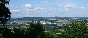
View from the Amöneburg to the Gilserberger Heights with the 379 m high Burgholz (left) and the Kellerwald behind it with the 657 m high Hohen Lohr (left, television tower), the 585 m high Jeust (center) and the 675 m high desert garden (right). In the left foreground the town of Kirchhain . |
||
| height | 379.1 m above sea level NHN | |
| location | Hessen , Germany | |
| Mountains | Gilserberger Heights | |
| Dominance | 7.6 km → Lischeider Berg northwest of Lischeid (in the NE) | |
| Notch height | 101 m ↓ Neustädter Sattel between Emsdorf and Erksdorf ( location ) | |
| Coordinates | 50 ° 52 '19 " N , 8 ° 56' 49" E | |
|
|
||
| particularities | Hunburgturm ( AT ) | |
The Burgholz is 379.1 m above sea level. NHN high mountain in the Gilserberger heights near Kirchhain in the Marburg-Biedenkopf district , on the summit or northeast slope of which is the Kirchhain district of the same name, Burgholz . Apart from a lane around the district, it is completely wooded.
geography
The Burgholz is the most south-westerly mountain of the Gilserberger Heights and merges directly into the Amöneburg Basin in the northern part of Kirchhain , while the Wohra valley joins it to the west , beyond which the southern Burgwald begins (separated from the northern , "real" by the B3 ). On its outer flanks are the places Emsdorf (in the east), higher parts of Langenstein and Kirchhain (in the south), the town of Rauschenberg (already in and behind the valley of the Wohra, in the west), Ernsthausen (in the northern valley) and Wolferode ( also in the valley, in the northeast).
Despite its low height, the Burgholz, as it just towers above the Amöneburg , has a dominance of around 10 km, which is broken to the north by the northern elevations of the same ridge, which are already in the immediate vicinity of the (significantly higher) Kellerwald .
view
The Hunburgturm has been standing on the summit of Burgholz since 1968 , a 28.5 m high wooden observation tower , which offers a 360 ° panoramic view of Kahlem Asten , Ziegenhelle , Bollerberg and Sackpfeife (841/816/757/674 m high, in the Rothaar Mountains ), to Dünsberg , Rimberg (each 498 m) and other elevations of the Gladenbacher Bergland , to the Knüll up to 636 m high , the Kellerwald up to 675 m high and the Vogelsberg up to 773 m high .

The Kellerwald with Hohem Lohr (657 m, left), Jeust (585 m, middle) and Wüstegarten (675 m, right); in the foreground, further elevations of the Gilserberger Heights
|

View of the southern Lahnberge with Frauenberg (370 m, half-left), Stempel (365 m, middle) and Lichtem Küppel (368 m, half-right) as well as the Dünsberg behind (498 m, right of middle) and other elevations of the Gladenbacher Bergland ( right)
|
Individual evidence
- ↑ Map services of the Federal Agency for Nature Conservation ( information )
- ↑ Lookout tower (Hunburgturm) on the website of the Kirchhain district of Burgholz
- ↑ Calculated 360 ° panorama ( U. Deuschle ; information ) from the Burgholzturm


