
Münchhausen (am Christenberg)
| coat of arms | Germany map | |
|---|---|---|
.svg)
|
Coordinates: 50 ° 57 ' N , 8 ° 43' E |
|
| Basic data | ||
| State : | Hesse | |
| Administrative region : | to water | |
| County : | Marburg-Biedenkopf | |
| Height : | 284 m above sea level NHN | |
| Area : | 41.54 km 2 | |
| Residents: | 3301 (Dec. 31, 2019) | |
| Population density : | 79 inhabitants per km 2 | |
| Postal code : | 35117 | |
| Primaries : | 06423, 06452, 06457 | |
| License plate : | MR, BID | |
| Community key : | 06 5 34 015 | |
| Community structure: | 5 districts | |
| Address of the municipal administration: |
Marburger Strasse 82 35117 Münchhausen |
|
| Website : | ||
| Mayor : | Peter Funk ( independent ) | |
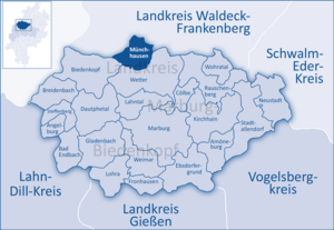
| Location of the community of Münchhausen in the Marburg-Biedenkopf district | ||
  |
||

The community of Münchhausen is located 20 kilometers north of the central Hessian university town of Marburg on the northern edge of the Marburg-Biedenkopf district . It has around 3400 inhabitants and was created in its current form as part of the regional reform in Hesse in 1974. The total area of the municipality is around 41 square kilometers.
geography
Geographical location
In the west of the community is the Rothaargebirge . The eastern boundary of the municipality is represented by the Burgwald , the elevation of which Christenberg is in the immediate vicinity of the Münchhausen district.
The district of Münchhausen itself and the district of Simtshausen are located in the Wetschaftstal ; Wollmar is located on the Wollmar of the same name, which flows into the Wetschaft in Münchhausen . The Asphe flows through the districts of Oberasphe and Niederasphe .
The community of Münchhausen lies on the Warburg – Sarnau railway line , which here, in its southern section, is called the “ Burgwaldbahn ”.
Neighboring communities
Münchhausen borders in the northwest on the city of Battenberg (Eder) , in the northeast on the municipality of Burgwald and the city of Rosenthal (all three in the Waldeck-Frankenberg district ), in the east and south on the city of Wetter , and in the west on the city of Biedenkopf (both in the Marburg-Biedenkopf district).
Districts
- Münchhausen (1250 inhabitants)
- Niederasphe (800 inhabitants)
- Oberasphe (325 inhabitants)
- Simtshausen (450 inhabitants)
- Wollmar (600 inhabitants)
(As of November 2019)
history
Human activities have been going on near Münchhausen on the Christenberg , a hill about two kilometers east of Münchhausen, since the Neolithic Age . Barrows were found in the western area of the Christenberg plateau , which could be the burial ground of a settlement on the Christenberg. In addition, there was a former Celtic or Frankish fortress on the Christenberg plateau . Today's Münchhausen was first mentioned in a document owned by the Würzburg State Archives in 1213. The name Münchhausen, which contains the place name Hausen , is typical for the establishment of settlements in the course of the Frankish conquest , which took place in the late 5th to 7th centuries. Like Munich , Münch goes back to the dative plural of the Old High German munih or Middle High German mün (e) ch, the forerunner of the word monk.
Incorporations
On July 1, 1974 within the framework of were municipal reform in Hesse , the hitherto independent communities of Munchausen Niederasphe, Simtshausen and Wollmar and the district Oberasphe the neighboring town of Battenberg (Eder) in Waldeck-Frankenberg powerful state law the new municipality Munchausen together .
Territorial history and administration
The following list gives an overview of the territories in which Münchhausen was located and the administrative units to which it was subordinate:
- until 1291/1296: Holy Roman Empire , court of the county of Battenberg
- around 1400: Holy Roman Empire, Kurmainz , Amt Battenberg
- from 1464: Holy Roman Empire, Landgraviate of Hesse , Battenberg Office
- from 1483: Holy Roman Empire, Landgraviate of Hesse, court of the Wetter office
- around 1526: Holy Roman Empire, Landgraviate of Hessen, again Amt Battenberg, then Amt Wetter (the Amt Wetter consisted of the places Wetter, Amönau, Oberndorf, Treisbach, Niederasphe, Unterſimtshausen, Todenhausen, Melnau, Ober- and Niederrosphe, Niederwetter, Göttingen, Sterzhausen , Warzenbach and Sarnau)
- from 1567: Holy Roman Empire, Landgraviate Hessen-Marburg , Wetteramt
- 1604–1648: Holy Roman Empire, disputed between Landgraviate Hessen-Darmstadt and Landgraviate Hessen-Kassel ( Hessian War ), Weather Office
- from 1648: Holy Roman Empire, Landgraviate Hessen-Kassel, Wetter office
- from 1803: Holy Roman Empire, Electorate of Hesse , Wetter office
- from 1806: Electorate of Hesse, Weather Office
- 1807–1813: Kingdom of Westphalia , Werra department , Marburg district , Wetter canton
- from 1815: German Confederation , Electorate of Hesse, Wetter office
- from 1821: German Confederation, Electorate of Hesse, Province of Upper Hesse , District of Marburg (separation of justice ( Justice Office Wetter ) and administration)
- from 1848: German Confederation, Electorate of Hesse, Marburg district
- from 1851: German Confederation, Electorate of Hesse, Province of Upper Hesse, District of Marburg
- from 1866: North German Confederation , Kingdom of Prussia , Province of Hesse-Nassau , District of Kassel , District of Marburg
- from 1871: German Empire , Kingdom of Prussia, Province of Hessen-Nassau, District of Kassel, District of Marburg
- from 1918: German Empire, Free State of Prussia , Province of Hessen-Nassau, Administrative Region of Kassel, District of Marburg
- from 1944: German Empire, Free State of Prussia, Province of Kurhessen , District of Marburg
- from 1945: American zone of occupation , Greater Hesse , Kassel district, Marburg district
- from 1949: Federal Republic of Germany , State of Hesse , Kassel district, Marburg district
- 1974: Federal Republic of Germany, Land Hessen, Kassel , Marburg-Biedenkopf
- from 1981: Federal Republic of Germany, State of Hesse, Gießen district, Marburg-Biedenkopf district
Courts since 1821
With an edict of June 29, 1821, administration and justice were separated in Kurhessen. Now judicial offices were responsible for the first instance jurisdiction, the administration was taken over by the districts. The Marburg district was responsible for the administration and the Wetter Judicial Office was the court of first instance for Münchhausen. The Supreme Court was the Higher Appeal Court in Kassel . The higher court of Marburg was subordinate to the province of Upper Hesse. It was the second instance for the judicial offices.
After the annexation of Kurhessen by Prussia, the judicial office of Wetter became the royal Prussian district court of Wetter in 1867. In June 1867, a royal ordinance was issued that reorganized the court system in the areas that belonged to the former Electorate of Hesse. The previous judicial authorities were to be repealed and replaced by local courts in the first, district courts in the second and an appeal court in the third instance. In the course of this, on September 1, 1867, the previous judicial office was renamed the Wetter District Court. The courts of the higher authorities were the Marburg District Court and the Kassel Court of Appeal .
Even with the entry into force of the Courts Constitution Act (GVG) in 1877, the district court remained in existence. In 1943 the district court became a branch of the district court of Marburg and in 1946 the branch was also closed. The district of the district court of Wetter merged with the district of the district court of Marburg.
In the Federal Republic of Germany, the superordinate instances are the Marburg Regional Court , the Frankfurt am Main Higher Regional Court and the Federal Court of Justice as the last instance.
population
Population development
Source: Historical local dictionary
| - | Information up to 1925 with Ober-, Mittelimtshausen and Schlagpuddze |
| • 1502: | 2 men |
| • 1577: | 97 house seats |
| • 1630: | 71 house seats (2 three-horse, 9 two-horse, 10 single-horse farm workers, 50 one- man walkers ) |
| • 1681: | 48 home-seated teams |
| • 1747: | 116 house seats |
| • 1838: | 126 local residents authorized to use, 53 local residents not authorized to use, 20 residents . |
| Münchhausen: Population from 1788 to 2015 | ||||
|---|---|---|---|---|
| year | Residents | |||
| 1788 | 703 | |||
| 1834 | 1,047 | |||
| 1840 | 1,139 | |||
| 1846 | 1.166 | |||
| 1852 | 1,249 | |||
| 1858 | 1,149 | |||
| 1864 | 1,070 | |||
| 1871 | 946 | |||
| 1875 | 934 | |||
| 1885 | 954 | |||
| 1895 | 1,064 | |||
| 1905 | 1,088 | |||
| 1910 | 1,089 | |||
| 1925 | 1,121 | |||
| 1939 | 888 | |||
| 1946 | 1,266 | |||
| 1950 | 1,269 | |||
| 1956 | 1,198 | |||
| 1961 | 1,161 | |||
| 1967 | 1,196 | |||
| 1972 | 1,240 | |||
| 1976 | 3,588 | |||
| 2000 | 3,700 | |||
| 2010 | 3,505 | |||
| 2015 | 3,400 | |||
| Data source: Historical municipality register for Hesse: The population of the municipalities from 1834 to 1967. Wiesbaden: Hessisches Statistisches Landesamt, 1968. Further sources:; 1972 :; 1976 :; 1984 :; 1992 :; 2000, 2015 :; 2010: From 1976 including the towns incorporated into Hesse as part of the regional reform . | ||||
Religious affiliation
Source: Historical local dictionary
| • 1861: | 1004 Evangelical Lutheran, 91 Evangelical Reformed inhabitants |
| • 1961: | 1074 Protestant, 82 Roman Catholic residents |
Gainful employment
Source: Historical local dictionary
| • 1788: | Employed workers: 1 bender , 3 blacksmiths, 2 tailors, 1 shoemaker, 1 bell caster, 1 bricklayer, 3 joiners, 3 landlords, 1 wagner, 3 carpenters, 2 brick makers, 6 millers, 4 shepherds |
| 1838: | Families: 112 agriculture, 67 businesses, 20 day laborers. |
| • 1961: | Labor force: 259 agriculture and forestry (43.2%), 213 manufacturing (35.5%), 76 trade and transport (12.7%), 52 services and other (8.7%). |
| • 2000: | Employees subject to social security contributions: 387 people. Thereof manufacturing 59.8%, trade, hospitality and transport: 18.8%, business services, public and private services 18.0%, other (or anonymized) 3.5% |
| • 2000: | Only marginally employed: 78 people. |
| • 2016: | Employees subject to social security contributions: 433 people. Thereof manufacturing industry 57.0%, trade, hospitality and transport: 11.5%, business services, public and private services 22.2%, other (or anonymized) 9.2% |
| • 2016: | Only marginally employed: 113 people. |
politics
Community representation
The local elections on March 6, 2016 produced the following results, compared to previous local elections:
| Parties and constituencies |
% 2016 |
Seats 2016 |
% 2011 |
Seats 2011 |
% 2006 |
Seats 2006 |
% 2001 |
Seats 2001 |
||
|---|---|---|---|---|---|---|---|---|---|---|
| SPD | Social Democratic Party of Germany | 47.4 | 11 | 46.3 | 11 | 41.6 | 10 | 40.8 | 10 | |
| CDU | Christian Democratic Union of Germany | 40.0 | 9 | 43.7 | 10 | 49.2 | 11 | 45.0 | 10 | |
| UGL | Independent Green List | 12.5 | 3 | 10.0 | 2 | 9.2 | 2 | 5.9 | 1 | |
| BLN | Niederasphe citizens list | - | - | - | - | - | - | 8.2 | 2 | |
| total | 100.0 | 23 | 100.0 | 23 | 100.0 | 23 | 100.0 | 23 | ||
| Voter turnout in% | 58.7 | 57.2 | 55.7 | 65.3 | ||||||
mayor
After the Hessian municipal constitution is Mayor Chairman of the Municipal Board , the six volunteers in the community Munchausen next to the Mayor Councilor belong. Since March 1, 1999, the mayor has been Peter Funk.
coat of arms
The coat of arms of the municipality shows in the red shield a silver (white) tip ending in a pawed cross , which is covered with a black, five-spoke wheel. The cross in the coat of arms symbolizes the Christenberg with its medieval church, the wheel with its five spokes refers to the five districts of the community. It reminds of the former affiliation to Kurmainz and is spread over large parts of the former Kurmainzer territory ( Mainzer Rad ).
Personalities
- Euricius Cordus (1486–1535), German humanist
- Johann Kahler (1649–1729), German mathematician and Lutheran theologian
Individual evidence
- ↑ Hessian State Statistical Office: Population status on December 31, 2019 (districts and urban districts as well as municipalities, population figures based on the 2011 census) ( help ).
- ↑ Law on the reorganization of the Biedenkopf and Marburg districts and the city of Marburg (Lahn) (GVBl. II 330-27) of March 12, 1974 . In: The Hessian Minister of the Interior (ed.): Law and Ordinance Gazette for the State of Hesse . 1974 No. 9 , p. 154 , § 2 ( online at the information system of the Hessian state parliament [PDF; 3.0 MB ]).
- ^ Federal Statistical Office (ed.): Historical municipality directory for the Federal Republic of Germany. Name, border and key number changes in municipalities, counties and administrative districts from May 27, 1970 to December 31, 1982 . W. Kohlhammer, Stuttgart / Mainz 1983, ISBN 3-17-003263-1 , p. 403 .
- ↑ a b c d e Münchhausen, Marburg-Biedenkopf district. Historical local dictionary for Hessen. (As of May 24, 2018). In: Landesgeschichtliches Informationssystem Hessen (LAGIS).
- ^ Michael Rademacher: German administrative history from the unification of the empire in 1871 to the reunification in 1990. State of Hesse. (Online material for the dissertation, Osnabrück 2006).
- ^ Georg Landau: Description of the Electorate of Hesse . T. Fischer, Kassel 1842, p. 389 ( online at HathiTrust's digital library ).
- ^ The affiliation of the weather office based on maps from the Historical Atlas of Hessen : Hessen-Marburg 1567–1604 . , Hessen-Kassel and Hessen-Darmstadt 1604–1638 . and Hessen-Darmstadt 1567–1866 .
- ^ Kur-Hessischer Staats- und Adress-Kalender: 1818 . Publishing house d. Orphanage, Kassel 1818, p. 123 ( online at Google Books ).
- ↑ Ordinance of August 30th, 1821, concerning the new division of the area , Annex: Overview of the new division of the Electorate of Hesse according to provinces, districts and judicial districts. Collection of laws etc. for the Electoral Hesse states. Year 1821 - No. XV. - August., ( Kurhess GS 1821) pp. 223-224
- ↑ Latest news from Meklenburg / Kur-Hessen, Hessen-Darmstadt and the free cities, edited from the best sources. in the publishing house of the GHG privil. Landes-Industrie-Comptouts., Weimar 1823, p. 158 ff . ( online at HathiTrust's digital library ).
- ↑ Ordinance on the constitution of the courts in the former Electorate of Hesse and the formerly Royal Bavarian territories with the exclusion of the enclave Kaulsdorf from June 19, 1867. ( PrGS 1867, pp. 1085-1094 )
- ↑ Order of August 7, 1867, regarding the establishment of the according to the Most High Ordinance of June 19 of this year. J. in the former Electorate of Hesse and the formerly Royal Bavarian territorial parts with the exclusion of the enclave Kaulsdorf, courts to be formed ( Pr. JMBl. Pp. 221–224 )
- ^ Local elections 1972; Relevant population of the municipalities on August 4, 1972 . In: The Hessian Minister of the Interior (ed.): State Gazette for the State of Hesse. 1972 No. 33 , p. 1424 , point 1025 ( online at the information system of the Hessian state parliament [PDF; 5.9 MB ]).
- ↑ Local elections 1977; Relevant population figures for the municipalities as of December 15, 1976 . In: The Hessian Minister of the Interior (ed.): State Gazette for the State of Hesse. 1976 No. 52 , p. 2283 , point 1668 ( online at the information system of the Hessian state parliament [PDF; 10.3 MB ]).
- ^ Local elections 1985; Relevant population of the municipalities as of October 30, 1984 . In: The Hessian Minister of the Interior (ed.): State Gazette for the State of Hesse. 1984 No. 46 , p. 2175 , point 1104 ( online at the information system of the Hessian state parliament [PDF; 5.5 MB ]).
- ↑ local elections 1993; Relevant population of the municipalities as of October 21, 1992 . In: The Hessian Minister of the Interior (ed.): State Gazette for the State of Hesse. 1992 No. 44 , p. 2766 , point 935 ( online at the information system of the Hessian state parliament [PDF; 6.1 MB ]).
- ↑ a b municipality data sheet : Münchhausen. (PDF; 222 kB) In: Hessisches Gemeindelexikon. HA Hessen Agency GmbH
- ↑ The population of the Hessian communities on June 30, 2010. (PDF; 552 kB) Hessisches Statistisches Landesamt, p. 11 , archived from the original on February 7, 2018 ; accessed on March 20, 2018 .
- ↑ a b anonymized
- ^ Result of the municipal election on March 6, 2016. Hessian State Statistical Office, accessed in April 2016 .
- ^ Hessian State Statistical Office: Result of the municipal elections on March 27, 2011
- ^ Hessian State Statistical Office: Result of the municipal elections on March 26, 2006
- ^ Hessian State Statistical Office: direct elections in Münchhausen
- ^ Münchhausen community: Mayor elections 2016 - election day and runoff day accessed on September 18, 2016
- ↑ Oberhessische Presse of September 14, 2016: Funk defeated Mengel - Appeal confirmed in office, accessed on September 18, 2016
literature
- Literature about Münchhausen in the Hessian Bibliography
- Search for Münchhausen (am Christenberg) in the archive portal-D of the German Digital Library
Web links
- Website of the community
- Münchhausen, Marburg-Biedenkopf district. Historical local dictionary for Hessen. In: Landesgeschichtliches Informationssystem Hessen (LAGIS).
- The geology of the large community Münchhausen

Amöneburg | Fishing castle | Bad Endbach | Biedenkopf | Breidenbach | Cölbe | Dautphetal | Ebsdorfergrund | Fronhausen | Gladenbach | Kirchhain | Lahn valley | Lohra | Marburg | Munchausen | Neustadt (Hessen) | Rauschenberg | Stadtallendorf | Steffenberg | Weimar (Lahn) | Weather (Hessen) | Wohratal