Hohenroda
| coat of arms | Germany map | |
|---|---|---|

|
Coordinates: 50 ° 48 ' N , 9 ° 55' E |
|
| Basic data | ||
| State : | Hesse | |
| Administrative region : | kassel | |
| County : | Hersfeld-Rotenburg | |
| Height : | 340 m above sea level NHN | |
| Area : | 35.74 km 2 | |
| Residents: | 3042 (Dec. 31, 2019) | |
| Population density : | 85 inhabitants per km 2 | |
| Postal code : | 36284 | |
| Area code : | 06676 | |
| License plate : | HEF, ROF | |
| Community key : | 06 6 32 010 | |
| Address of the municipal administration: |
Schlossstrasse 45 36284 Hohenroda |
|
| Website : | ||
| Mayor : | Andre Stenda (independent) | |
| Location of the community Hohenroda in the district of Hersfeld-Rotenburg | ||
Hohenroda is a municipality in the district of Hersfeld-Rotenburg in East Hesse (Germany) on the border with Thuringia .
geography
The community is located in the Kuppenrhön . The highest point of the Hessian bowling game , the Soisberg, lies on the western border of the municipality.
The next larger cities are Bad Hersfeld (about 20 km northwest) and Fulda (about 32 km southwest).
Neighboring communities
Hohenroda borders in the north on the municipality of Philippsthal (in the district of Hersfeld-Rotenburg), in the east on the municipality of Unterbreizbach , in the southeast on the municipality of Buttlar (both in the Thuringian Wartburg district ), in the south on the municipality of Eiterfeld (in the district of Fulda ), in the west to the community of Schenklengsfeld and in the northwest to the community of Friedewald (both in the district of Hersfeld-Rotenburg).
Community structure
The community consists of the districts Ausbach , Glaam , Mansbach , Oberbreitzbach , Ransbach and Soislieden .
history
The municipality of Mansbach was first mentioned in a document in 1232 and has probably been dependent on the knighthood of Mansbach since its inception. Ransbach followed with its first mention in 1254, as the village of the Landeck office .
The lords of Mansbach built a semi-independent petty lordship here, in which they could take advantage of relationships with the neighboring abbeys of Fulda and Hersfeld and the Landgraves of Hesse .
Mansbach Castle was destroyed by Abbot Bertho IV of Fulda between 1274 and 1286. After the reconstruction, it was temporarily a fiefdom and sometimes an allod in the 14th and 15th centuries . In 1364 the Mansbachs received jurisdiction over the place from the Fulda Abbey. In 1662 the lords of Geyso bought property from the Mansbachs and built a castle here. Until the media coverage in 1806, the village was occupied by the Abbey of Fulda as landsässig, but it was virtually three rich free manorial estates .
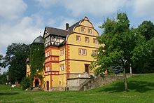
At the beginning of the 20th century, the manufacturer Adolf Hupertz (then also the owner of Rieneck Castle ) became the owner of 1,700 acres of land between Mansbach, Glaam and Oberbreitzbach. He made an estate out of it and called the estate, or the estate district Hohenroda, which from now on belonged to the municipality of Oberbreitzbach. Between 1907 and 1909, Hupertz had a mansion with a park built in the manor district. He named the complex Schloss Hohenroda . When the large community was founded on February 1, 1971, the name of the estate or the castle was transferred to the community. Since 1988 the administrative center of the municipality has been located in the former manor house, which it bought in 2007.
Incorporations
The community of Hohenroda was created on February 1, 1971 through the merger of the communities of Mansbach ( district of Hünfeld ) and Ransbach. On February 1, 1972, the community of Ausbach was added.
In advance, Glaam was incorporated into Ransbach on September 1, 1968, Soislieden was incorporated into Mansbach on January 1, 1970 and Oberbreitzbach on July 1, 1970.
politics
Community representation
The local elections on March 6, 2016 produced the following results, compared to previous local elections:
| Parties and constituencies |
% 2016 |
Seats 2016 |
% 2011 |
Seats 2011 |
% 2006 |
Seats 2006 |
% 2001 |
Seats 2001 |
||
|---|---|---|---|---|---|---|---|---|---|---|
| SPD | Social Democratic Party of Germany | 44.9 | 10 | 50.1 | 12 | 65.6 | 15th | 68.9 | 16 | |
| FWH | Free voter group Hohenroda | 31.3 | 7th | 21.5 | 5 | - | - | - | - | |
| CDU | Christian Democratic Union of Germany | 13.0 | 3 | 15.4 | 3 | 21.3 | 5 | 22.6 | 5 | |
| FDP | Free Democratic Party | 10.8 | 3 | 13.0 | 3 | 13.1 | 3 | 8.5 | 2 | |
| total | 100.0 | 23 | 100.0 | 23 | 100.0 | 23 | 100.0 | 23 | ||
| Voter turnout in% | 58.7 | 58.1 | 55.2 | 66.6 | ||||||
mayor
Andre Stenda has been mayor of Hohenroda (independent) since September 1, 2013. He was elected in the mayoral election on May 12, 2013 with a vote of 70.7%. The turnout was 74.3%.
Stenda was the youngest mayor of Hesse when he took office.
coat of arms
Blazon : "In a silver and red shield with six bars, a six-leaf in mixed up colors."
Meaning: The six leaves symbolize the amalgamation of the six independent communities to form one large community. The leaves belong to an apple tree and thus refer to the apple variety Ausbacher Rotapfel , which is named after the district of Ausbach and which is still often grown on orchards in the area. The colors silver and red are derived from the coats of arms of the Lords of Mansbach, the Electorate of Hesse and the municipality of Ransbach. The change of status comes from the coat of arms of those of Mansbach.
Culture and sights
Museums
- Heimatstube in the half-timbered extension of the Geyso Castle in Mansbach
- Heimatstube in the Ausbach district
- Museum in Ransbach
- Border documentation office (to the border of the former GDR )
Buildings
- Baroque village church of Mansbach (choir around 1280, former burial chapel of the von Mansbach family)
- Unterhof (Blue Castle) from 1569 (residence of the von Mansbach family)
- Geyso Castle (1577–1578) in Mansbach
- Grasburg near Mansbach (from the 8th century)
- Jewish cemetery Mansbach
- Hohenroda Castle
Individual evidence
- ↑ Hessian State Statistical Office: Population status on December 31, 2019 (districts and urban districts as well as municipalities, population figures based on the 2011 census) ( help ).
- ↑ a b Federal Statistical Office (ed.): Historical municipality register for the Federal Republic of Germany. Name, border and key number changes in municipalities, counties and administrative districts from May 27, 1970 to December 31, 1982 . W. Kohlhammer GmbH, Stuttgart / Mainz 1983, ISBN 3-17-003263-1 , p. 396, 397 and 399 .
- ^ Result of the municipal election on March 6, 2016. Hessian State Statistical Office, accessed in April 2016 .
- ^ Hessian State Statistical Office: Result of the municipal elections on March 27, 2011
- ^ Hessian State Statistical Office: Result of the municipal elections on March 26, 2006
Web links
- "Hohenroda, District of Hersfeld-Rotenburg". Historical local dictionary for Hessen. In: Landesgeschichtliches Informationssystem Hessen (LAGIS).
- Literature about Hohenroda in the Hessian Bibliography
- Link catalog on Hohenroda at curlie.org (formerly DMOZ )


