Friedewald (Hesse)
| coat of arms | Germany map | |
|---|---|---|

|
Coordinates: 50 ° 53 ' N , 9 ° 52' E |
|
| Basic data | ||
| State : | Hesse | |
| Administrative region : | kassel | |
| County : | Hersfeld-Rotenburg | |
| Height : | 388 m above sea level NHN | |
| Area : | 39.65 km 2 | |
| Residents: | 2449 (Dec. 31, 2019) | |
| Population density : | 62 inhabitants per km 2 | |
| Postal code : | 36289 | |
| Primaries : | 06674, 06629 (Motzfeld) | |
| License plate : | HEF, ROF | |
| Community key : | 06 6 32 006 | |
| Community structure: | 4 districts | |
| Address of the municipal administration: |
Schlossplatz 2 36289 Friedewald |
|
| Website : | ||
| Mayor : | Dirk Noll ( SPD ) | |
| Location of the community Friedewald in the district of Hersfeld-Rotenburg | ||
Friedewald is a municipality in the Hersfeld-Rotenburg district in eastern Hesse , directly east of Bad Hersfeld . Friedewald advertises with the name "Future Community for Generations".
geography
Geographical location

The community lies in the border area between the Kuppenrhön and the Seulingswald . Friedewald lies on the watershed between Fulda and Werra . The place Friedewald is north of the Dreienberg , which belongs to the northernmost foothills of the Rhön and south of the Toten Mann , the highest elevation of the Seulingswald.
Neighboring communities
Friedewald borders the communities of Ronshausen and Wildeck in the north, the city of Heringen and the community of Philippsthal in the east, the community Hohenroda in the southeast, the community Schenklengsfeld in the south and the city Bad Hersfeld and the community Ludwigsau (all in the District of Hersfeld-Rotenburg).
Community structure
The community consists of the core community of the districts Hillartshausen , Lautenhausen and Motzfeld .
history
Until the 19th century
The office of Friedewald was mentioned in 1392 (with market rights and jurisdiction) and the place Friedewald was first mentioned in writing in 1430. An abbey castle stood here before 1302, which was given to the Landgraviate of Hesse as a Hersfeld fief that year . The castle was probably built to control the Kurz Hessen trade route , which ran from Frankfurt to Leipzig .
In 1472 this castle was demolished, and Landgrave Heinrich III. The Friedewald moated castle was built here by his master builder Hans Jakob von Ettlingen , which the landgraves used for hunting trips. On October 5, 1551, the treaty between France and the Narrow Kaldic princes for the liberation of Landgrave Philip of Hesse from imperial captivity was concluded here. Friedewald Castle with its four corner towers was destroyed in 1762. The castle is still the center of the village and the symbol of the community.
During the time of the Napoleonic Kingdom of Westphalia (1807-1813), Friedewald was the capital of the canton of Friedewald and the seat of the justice of the peace .
Incorporations
On December 31, 1971, the previously independent communities Hillartshausen and Lautenhausen were incorporated as part of the regional reform in Hesse . Motzfeld was added on August 1, 1972.
religion
In Friedewald there are the following denominations, each with a church:
Protestant church
The Ev. The rectory of the parish on Dreienberg is at Pfarrweg 1. The Protestant church is located in Motzfelder Strasse 5, not far from the former moated castle.
Catholic Church
The Catholic Church in Friedewald is a branch church that is consecrated to St. John and is located in Wiesenstrasse 8 / corner of Gartenstrasse. In terms of canon law, it belongs to the Catholic parish of St. Robert in Heringen in the diocese of Fulda .
politics
Community representation
The local elections on March 6, 2016 produced the following results, compared to previous local elections:
|
Distribution of seats in the municipal council 2016
A total of 15 seats
|
Parties and constituencies |
% 2016 |
Seats 2016 |
% 2011 |
Seats 2011 |
% 2006 |
Seats 2006 |
% 2001 |
Seats 2001 |
|
|---|---|---|---|---|---|---|---|---|---|---|
| SPD | Social Democratic Party of Germany | 61.0 | 9 | 44.0 | 7th | 59.4 | 9 | 46.7 | 7th | |
| OIL | Open list | 39.0 | 6th | 39.9 | 6th | - | - | - | - | |
| CDU | Christian Democratic Union of Germany | - | - | 16.1 | 2 | 21.0 | 3 | 33.4 | 5 | |
| BpF | Citizen list pro Friedewald | - | - | - | - | - | - | 17.5 | 3 | |
| FDP | Free Democratic Party | - | - | - | - | - | - | 2.4 | 0 | |
| total | 100.0 | 15th | 100.0 | 15th | 100.0 | 15th | 100.0 | 15th | ||
| Voter turnout in% | 55.5 | 55.3 | 58.4 | 74.1 | ||||||
mayor
Dirk Noll ( SPD ) was elected mayor on September 16, 2012 with 67.2% of the votes. On October 28, 2018, Mayor Noll was elected to his second term with 93.1%.
coat of arms
Blazon : “In red a silver castle silhouette with battlements in front of it, in black the silhouette of a three-bowl fountain. In the head of the shield there are four silver oak leaves with oak fruit. "
Culture and sights
Museums
Friedewald local history museum in the southern stables of the outer bailey.
Buildings

- Ruin of the moated castle Friedewald with four defense towers made of Friedewald sandstone , the Landgrave of Hesse from the 15th century and outer bailey from around 1600.
- In the middle of the palace square there is a baroque three-bowl fountain.
- Hammundeseiche (from this deserted village you can find the rebuilt walls of the church, the village pond, the well and the "big oak" (1000 year old village oak))
- "Zollstock" (former border post on the border between Hesse , Thuringia and Grabfeld , which had existed here for a long time since 1306).
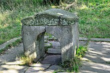
- The eye of a needle (first mentioned in 1579 and described as a hollow oak, it was considered beneficial to crawl through it. The decayed tree was probably replaced by a gate-like stone in the late 16th century.)
- four Protestant churches (Friedewald, OT Motzfeld, OT Lautenhausen and OT Hillartshausen)
- Tower ruins of the Gißlingskirche in the deserted village of Gosselndorf
- Ruins of the Walterskirche in the deserted village of Waldradeberg
- Ruin of a watchtower of the Drygenburg
- War memorial 1914–1918 by sculptor Arnold Rechberg
Parks and natural monuments
- Hammundeseiche (an oak near the deserted village of the same name)
Economy and Infrastructure
traffic
The municipality is located on the federal motorway 4 (junction 33). Furthermore, the federal road 62 runs through the community from Bad Hersfeld to Bad Salzungen. Local public transport is carried out by ÜWAG Bus GmbH with lines 330, 331 and 345 and by Verkehrsgesellschaft Wartburgkreis mbH with line 300.
Established businesses
The Friedewald West industrial park is located directly on the motorway access road to the important east-west connection A4. At the beginning of 2009, Hermes put its newest HUB (main handling base) into operation on an area of 100,000 m² with an 18,000 m² building. In addition, Schenker Deutschland AG runs one of the most powerful HUBs in Europe. It is of central importance for Schenker, especially for general cargo shipments within Germany. In addition, there are other efficient businesses and craftsmen, shops, banks, medical practices, pharmacies, schools, sports and leisure facilities in Friedewald. Thus Friedewald offers an attractive job offer, so that the community is not only considered as a place of residence for many people, but also as the center of the working world.
Sons and daughters of the church
- Karl Bernhard Hundeshagen (1810–1872), Reformed theologian
- August Spies (1855-1887), journalist
- Konrad Zilch (* 1944), civil engineer
- Dieter Deiseroth (1950–2019), lawyer, judge at the Federal Administrative Court
Web links
- Internet presence of the Friedewald community
- Friedewald, Hersfeld-Rotenburg district. Historical local dictionary for Hessen. In: Landesgeschichtliches Informationssystem Hessen (LAGIS).
- Mayoral elections in Friedewald on statistik-hessen.de
Individual evidence
- ↑ Hessian State Statistical Office: Population status on December 31, 2019 (districts and urban districts as well as municipalities, population figures based on the 2011 census) ( help ).
- ^ "Future community for generations" - LOGO and SLOGAN new for the community. In: Osthessen News. Retrieved July 26, 2019 .
- ↑ Law on the reorganization of the districts of Hersfeld and Rotenburg (GVBl. II 330-13) of July 11, 1972 . In: The Hessian Minister of the Interior (ed.): Law and Ordinance Gazette for the State of Hesse . 1972 No. 17 , p. 217 , § 8 ( online at the information system of the Hessian state parliament [PDF; 1,2 MB ]).
- ^ Federal Statistical Office (ed.): Historical municipality directory for the Federal Republic of Germany. Name, border and key number changes in municipalities, counties and administrative districts from May 27, 1970 to December 31, 1982 . W. Kohlhammer, Stuttgart / Mainz 1983, ISBN 3-17-003263-1 , p. 396 f .
- ^ Result of the municipal election on March 6, 2016. Hessian State Statistical Office, accessed in April 2016 .
- ^ Hessian State Statistical Office: Result of the municipal elections on March 27, 2011
- ^ Hessian State Statistical Office: Result of the municipal elections on March 26, 2006
- ^ Museum Friedewald , accessed in August 2018.
- ↑ Ev. Parish at Dreienberg Friedewald
- ^ Götz J. Pfeiffer: Memorial sites in Bad Hersfeld and Friedewald with sculptures by Arnold Rechberg . In: Hessische Heimat, 67th year, 2017, issue 2/3 . S. 89-94 .
- ^ Entry in the directory of monumental oaks . Retrieved January 10, 2017


