Dead Man (Seulingswald)
| dead man | ||
|---|---|---|
|
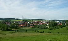
View from Petersberg over Sorga in the Solz valley to the northeast to the Toten Mann , the highest mountain in the Seulingswald |
||
| height | 480.3 m above sea level NHN | |
| location | at Friedewald ; District of Hersfeld-Rotenburg , Hessen ( Germany ) | |
| Mountains | Seulingswald | |
| Coordinates | 50 ° 54 '1 " N , 9 ° 50' 20" E | |
|
|
||
| Type | Ridges | |
| rock | Sandstone | |
| particularities | Highest natural mountain in the Seulingswald | |
The dead man in Friedewald in Hesse Hersfeld-Rotenburg is 480.3 m above sea level. NHN the highest natural mountain in the Seulingswald . This small mountain range is the southernmost branch of the Fulda-Werra-Bergland .
geography
location
The dead man lies in the southernmost area of the Seulingswald. Its summit is located 2.5 km north of Friedewald and is part of its locality. The south-western slope is in the district of Kathus , a district of Bad Hersfeld near the Solz . The western slope is located in the district of the 3.8 km north-westerly from the summit Meckbach , one at Fulda influx Meckbach district of located Ludwigsau . The northeast slope is in the district of Ronshausen , which is traversed by the Ulfe tributary to the Fulda . The Faßdorf estate belonging to Ronshausen in the valley of the Breitenbach is 4.1 km (as the crow flies ) north of the summit.
On the western slope of the mountain, the Fulda tributary Meckbach rises with many upper tributaries (e.g. Kirchgrund, Sälig, Finstertal). The Ulfe tributary Breitenbach runs east and north of the mountain. The Breitzbach tributary of the Solz rises on the southwest slope .
Natural allocation
The Dead Man belongs to the main natural unit group Osthessisches Bergland (No. 35), in the main unit Fulda-Werra-Bergland (357) and in the subunit Solztrotten- and Seulingswald (357) the natural area Seulingswald (357.20).
Protected areas
On the Ostnordostflanke the dead man lying parts of the protected landscape Seulingswald ( CDDA -No 378,688;. Reported in 1979; 30.2656 square kilometers in size). On the mountain there are those of the fauna-flora-habitat area Seulingswald (FFH no. 378688; 23.2315 km²).
Traffic and walking
The dead man can be reached on Kreisstraße 1, which branches off from Bundesstraße 27 in Ludwigsau and leads east to Meckbach, where it ends as a spur road, and on K 2, which branches off from B 62 in Sorga and also as The cul-de-sac runs north-east to Kathus. From the north, the K 69 leads up to the mountain, which branches off from state road 3251 in Ronshausen and runs as a spur road to Faßdorf. From Friedewald you can reach the mountain via a dirt road that leads out of the village in a north-north-westerly direction and crosses federal motorway 4 . The motorway leads southeast of Berg near the Stangenrück ( 465.7 m ) at a maximum of about 445 m and thus only about 35 meters below its summit; The Friedewald junction is also located here . There are two wind turbines there . The Waldhessen cycle path R13 , which leads from Sontra to Neukirchen, also runs here. For example, starting at the end of the aforementioned spur roads, the mountain can be visited on many forest and hiking trails.
References and comments
- ↑ a b Map services of the Federal Agency for Nature Conservation ( information )
- ↑ The Dead Man is the highest natural mountain ( 480.3 m ) in the Seulingswald and is dominated by the Monte Kali waste dump (approx. 530 m ).


