
Ligueil
| Ligueil | ||
|---|---|---|
.svg)
|
|
|
| region | Center-Val de Loire | |
| Department | Indre-et-Loire | |
| Arrondissement | Loches | |
| Canton | Descartes | |
| Community association | Loches Sud Touraine | |
| Coordinates | 47 ° 3 ' N , 0 ° 49' E | |
| height | 66–128 m | |
| surface | 29.72 km 2 | |
| Residents | 2,188 (January 1, 2017) | |
| Population density | 74 inhabitants / km 2 | |
| Post Code | 37240 | |
| INSEE code | 37130 | |
| Website | http://www.ville-ligueil.fr/ | |
 Ligueil Town Hall |
||

Ligueil is a French commune with a population of 2,188 (as at 1st January 2017) in Indre-et-Loire in the region of Center-Val de Loire ; it belongs to the arrondissement of Loches and the canton of Descartes (until 2015: canton of Ligueil ). The inhabitants are called Ligolia .
geography
Ligueil is located about 40 kilometers south-southeast of Tours on the Esves River . Ligueil is surrounded by the neighboring communities of La Chapelle-Blanche-Saint-Martin in the north, Vou in the northeast, Ciran in the east, Ferrière-Larçon in the southeast, Paulmy in the south, Cussay in the southwest, Civray-sur-Esves in the west and Bournan in the northwest .
Population development
| year | 1962 | 1968 | 1975 | 1982 | 1990 | 1999 | 2006 | 2012 |
| Residents | 2.110 | 2,245 | 2,379 | 2,413 | 2,201 | 2,166 | 2,155 | 2,246 |
Attractions
- Saint-Martin church from the 12th century
- Notre-Dame-de-Anges chapel
- La Tourmelière castle from the 17th century
- Epigny Castle from the 18th century
- Town hall with chancellery
- hospice
- 19th century Edmaine Mill
- Old dairy
- Wash house
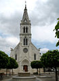
Saint Martin Church

chancellery

Wash house


Community partnerships
There is a partnership with the British community of Hungerford in Berkshire, England .
literature
- Le Patrimoine des Communes d'Indre-et-Loire. Flohic Editions, Volume 2, Paris 2001, ISBN 2-84234-115-5 , pp. 738-755.