
Reignac-sur-Indre
| Reignac-sur-Indre | ||
|---|---|---|
.svg)
|
|
|
| region | Center-Val de Loire | |
| Department | Indre-et-Loire | |
| Arrondissement | Loches | |
| Canton | Loches | |
| Community association | Loches Sud Touraine | |
| Coordinates | 47 ° 14 ' N , 0 ° 55' E | |
| height | 60-101 m | |
| surface | 22.44 km 2 | |
| Residents | 1,238 (January 1, 2017) | |
| Population density | 55 inhabitants / km 2 | |
| Post Code | 37310 | |
| INSEE code | 37192 | |
| Website | http://www.reignac-sur-indre.fr/ | |
 Town hall (Mairie) of Reignac-sur-Indre |
||

Reignac-sur-Indre is a French commune with 1,238 inhabitants (as of January 1 2017) in the department of Indre-et-Loire in the region of Center-Val de Loire ; Reignac-sur-Indre belongs to the Arrondissement of Loches and the Canton of Loches . The inhabitants are called Reignacois .
geography
Reignac-sur-Indre is about 24 kilometers southeast of Tours on the Indre . Reignac-sur-Indre is surrounded by the neighboring municipalities of Cigogné in the north and northeast, Chédigny in the east, Azay-sur-Indre in the southeast, Dolus-le-Sec in the south, Tauxigny-Saint-Bauld in the west and southwest and Courçay in the west and Northwest.
Population development
| 1962 | 1968 | 1975 | 1982 | 1990 | 1999 | 2006 | 2013 |
|---|---|---|---|---|---|---|---|
| 653 | 645 | 685 | 842 | 909 | 1,068 | 1,171 | 1,176 |
| Source: Cassini and INSEE | |||||||
Attractions
- Dolmen La Guginadière
- Saint-Etienne church, a historic monument since 1926
- Reignac Castle
- Villepays mansion
- Reignac Mill

Saint-Etienne church

Reignac Castle

Villepays mansion
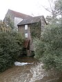
Mill


literature
- Le Patrimoine des Communes d'Indre-et-Loire. Flohic Editions, Volume 2, Paris 2001, ISBN 2-84234-115-5 , pp. 848-851.
Web links
Commons : Reignac-sur-Indre - Collection of images, videos and audio files