Genillé
| Genillé | ||
|---|---|---|

|
|
|
| region | Center-Val de Loire | |
| Department | Indre-et-Loire | |
| Arrondissement | Loches | |
| Canton | Loches | |
| Community association | Loches Sud Touraine | |
| Coordinates | 47 ° 11 ′ N , 1 ° 6 ′ E | |
| height | 71-144 m | |
| surface | 63.12 km 2 | |
| Residents | 1,521 (January 1, 2017) | |
| Population density | 24 inhabitants / km 2 | |
| Post Code | 37460 | |
| INSEE code | 37111 | |
| Website | www.genille.eu | |
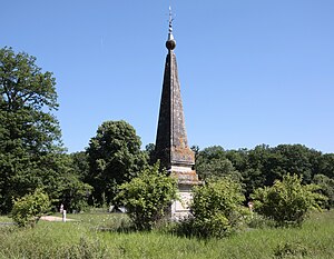
 Pyramid of Genillé |
||
Genillé is a French commune with 1,521 inhabitants (at January 1, 2017) in Indre-et-Loire in the region of Center-Val de Loire .
geography
The municipality of Genillé on the Indrois , a 69 kilometer long tributary of the Indre , is 40 kilometers southeast of Tours .
history
Genillé is an old place whose name appears for the first time in the 7th century on coins from the Merovingian period. The first Seigneur of Genillé was Adam Fumée , humanist and doctor of Charles VII and Louis XI. From 1492 to 1494 he was the keeper of the seal with the “withdrawn” or unavailable chancellor. In Genillé he took care of the restoration of the Sainte-Eulalie church. At the end of the 15th century he began building Genillé Castle. The houses of the village stretch up the slope between the castle and the river.
Attractions
- The Church of Genillé is St. Dedicated to Eulalia of Mérida . The bell tower, built towards the end of the 11th century, is the oldest part of the structure. In 1145 the church fell victim to the armed conflict between Sulpice II , Sire d'Amboise, and Robert le Fort , Count of Anjou . The destroyed nave was rebuilt in the 13th century. The choir and apse , which receives their light through three windows decorated with flamboyant tracery , date from 1523, probably added by Adam Fumée .
- The Genillé Castle was completed in the 15th and 16th centuries, except for the modern north wing. The original complex includes the rectangular main building, two round corner towers, watchtowers and a polygonal stair tower.
- In the “Forst von Loches ”, southwest of Genillé, you will find the “Pyramid of Genillé” on the road. It is one of a total of four "markings" that had been set up by 1778 on a widened path through the forest that was opened in 1769. With a forester's house in the neighborhood, the obelisk- shaped signs have since highlighted important crossroads.
Sons and daughters of the town
- Gérard Marinier (1899-?), Racing car driver
gallery
literature
- Le Patrimoine des Communes d'Indre-et-Loire. Flohic Editions, Volume 2, Paris 2001, ISBN 2-84234-115-5 , pp. 978-983.
- Castles on the Loire . The green travel guide. Michelin Reise-Verlag, Landau-Mörlheim 1997, ISBN 2-06-711591-X , p. 240.
Web links
- Genillé on cartesfrance.fr (French)


