
Chambourg-sur-Indre
| Chambourg-sur-Indre | ||
|---|---|---|
|
||
| region | Center-Val de Loire | |
| Department | Indre-et-Loire | |
| Arrondissement | Loches | |
| Canton | Loches | |
| Community association | Loches Sud Touraine | |
| Coordinates | 47 ° 11 ′ N , 0 ° 58 ′ E | |
| height | 62-119 m | |
| surface | 28.39 km 2 | |
| Residents | 1,291 (January 1, 2017) | |
| Population density | 45 inhabitants / km 2 | |
| Post Code | 37310 | |
| INSEE code | 37049 | |
| Website | http://www.chambourg-sur-indre.fr/ | |
 Town hall (Mairie) of Chambourg-sur-Indre |
||

Chambourg-sur-Indre is a French commune with 1,291 inhabitants (as of January 1 2017) in the department of Indre-et-Loire in the region of Center-Val de Loire ; Chambourg-sur-Indre belongs to the Arrondissement of Loches and the Canton of Loches . The inhabitants are called Chambourgeois .
geography
Chambourg-sur-Indre is about 31 kilometers south-east of Tours on the Indre . Chambourg-sur-Indre is surrounded by the neighboring communities of Azay-sur-Indre in the north and north-west, Chédigny in the north and north-east, Saint-Quentin-sur-Indrois in the east and north-east, Ferrière-sur-Beaulieu in the east and south-east, Loches and Chanceaux-près-Loches in the south and Dolus-le-Sec in the west.
Population development
| 1962 | 1968 | 1975 | 1982 | 1990 | 1999 | 2006 | 2013 |
|---|---|---|---|---|---|---|---|
| 925 | 883 | 779 | 857 | 1,080 | 1,194 | 1,272 | 1,372 |
| Source: Cassini and INSEE | |||||||
Attractions
- Roman settlement remains
- Saint-Martin church from 11th / 12th centuries century
- Remains of the gothic bridge to the island Auger from the 15th century, monument historique since 1927
- Chavigny mansion from the 17th century
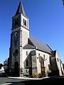
Saint Martin Church

Arch remains of the Gothic bridge to the island of Auger


literature
- Le Patrimoine des Communes d'Indre-et-Loire. Flohic Editions, Volume 2, Paris 2001, ISBN 2-84234-115-5 , pp. 811-813.