
Orbigny
| Orbigny | ||
|---|---|---|

|
|
|
| region | Center-Val de Loire | |
| Department | Indre-et-Loire | |
| Arrondissement | Loches | |
| Canton | Loches | |
| Community association | Loches Sud Touraine | |
| Coordinates | 47 ° 13 ' N , 1 ° 14' E | |
| height | 98-182 m | |
| surface | 65.88 km 2 | |
| Residents | 732 (January 1, 2017) | |
| Population density | 11 inhabitants / km 2 | |
| Post Code | 37460 | |
| INSEE code | 37177 | |
| Website | http://www.orbigny.fr/ | |
.jpg) Orbigny town hall (Mairie) |
||

Orbigny is a municipality with 732 inhabitants (as of January 1 2017) in the French department of Indre-et-Loire in the region of Center-Val de Loire . It belongs to the Arrondissement of Loches and the canton of the same name (until 2015: Canton of Montrésor ). The inhabitants are called Orbignois .
location
Orbigny is about 44 kilometers east-southeast of Tours and borders on Céré-la-Ronde in the north and northwest, Mareuil-sur-Cher in the north and northeast, Saint-Aignan in the east and northeast, Châteauvieux in the east, Nouans-les-Fontaines in the south and south-east, Villeloin-Coulangé in the south, Beaumont-Village in the west and south-west and Genillé in the west.
Population development
| year | 1962 | 1968 | 1975 | 1982 | 1990 | 1999 | 2006 | 2013 |
|---|---|---|---|---|---|---|---|---|
| Residents | 1,081 | 1,045 | 846 | 785 | 721 | 727 | 747 | 756 |
| Source: Cassini and INSEE | ||||||||
Attractions
- Saint-Vincent church from the 11th century, monument historique
- Le Mousseau castle
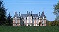
- L'Estang Castle
- Mill of olivine

Saint Vincent Church
Le Mousseau castle

L'Estang Castle
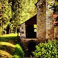
Mill of olivine


