
Loché-sur-Indrois
| Loché-sur-Indrois | ||
|---|---|---|
.svg)
|
|
|
| region | Center-Val de Loire | |
| Department | Indre-et-Loire | |
| Arrondissement | Loches | |
| Canton | Loches | |
| Community association | Loches Sud Touraine | |
| Coordinates | 47 ° 6 ′ N , 1 ° 13 ′ E | |
| height | 98-152 m | |
| surface | 74.13 km 2 | |
| Residents | 506 (January 1, 2017) | |
| Population density | 7 inhabitants / km 2 | |
| Post Code | 37460 | |
| INSEE code | 37133 | |
 Town hall (Mairie) of Loché-sur-Indrois |
||

Loché-sur-Indrois is a municipality with 506 inhabitants (as of January 1 2017) in the French department of Indre-et-Loire in the region of Center-Val de Loire . It belongs to the Arrondissement of Loches and the canton of the same name (until 2015: Canton of Montrésor ).
location
Loché-sur-Indrois is about 58 kilometers southeast of Tours am Indrois and borders Chemillé-sur-Indrois in the north and northwest, Villeloin-Coulangé in the north and northeast, Nouans-les-Fontaines in the east and northeast, Villedômain in the southeast, and Châtillon -sur-Indre in the south, Saint-Cyran-du-Jambot in the south-west, Saint-Hippolyte in the west and south-west, and Sennevières in the west and north-west.
Population development
| year | 1962 | 1968 | 1975 | 1982 | 1990 | 1999 | 2006 | 2013 |
|---|---|---|---|---|---|---|---|---|
| Residents | 968 | 872 | 721 | 582 | 556 | 532 | 516 | 550 |
| Source: Cassini and INSEE | ||||||||
Attractions
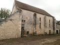
- Beaugerais Monastery , founded in 1153, dissolved in 1791, Monument historique
- Saint-Barthélémy-et-Saint-Laurent church from the 12th century, monument historique since 1952
- Loché Castle
- Pyramid of Saint Hubert
Beaugerais monastery church

Saint-Barthélémy-et-Saint-Laurent church

Pyramid of Saint Hubert


literature
- Le Patrimoine des Communes d'Indre-et-Loire. Flohic Editions, Volume 2, Paris 2001, ISBN 2-84234-115-5 , pp. 985-991.