
Saint-Quentin-sur-Indrois
| Saint-Quentin-sur-Indrois | ||
|---|---|---|
|
||
| region | Center-Val de Loire | |
| Department | Indre-et-Loire | |
| Arrondissement | Loches | |
| Canton | Loches | |
| Community association | Loches Sud Touraine | |
| Coordinates | 47 ° 12 ' N , 1 ° 1' E | |
| height | 65-127 m | |
| surface | 27.23 km 2 | |
| Residents | 510 (January 1, 2017) | |
| Population density | 19 inhabitants / km 2 | |
| Post Code | 37310 | |
| INSEE code | 37234 | |
 Town hall (Mairie) of Saint-Quentin-sur-Indrois |
||

Saint-Quentin-sur-Indrois is a French municipality with 510 inhabitants (as of January 1 2017) in the department of Indre-et-Loire in the region of Center-Val de Loire ; Tauxigny belongs to the Arrondissement of Loches and the Canton of Loches . The inhabitants are called Reignacois .
geography
Saint-Quentin-sur-Indrois is located about 32 kilometers southeast of Tours on the Indrois . Saint-Quentin-sur-Indrois is surrounded by the neighboring communities of Sublaines in the north and northeast, Luzillé in the northeast, Genillé in the east, Ferrière-sur-Beaulieu in the south, Chambourg-sur-Indre in the southwest and Chédigny in the west.
Population development
| 1962 | 1968 | 1975 | 1982 | 1990 | 1999 | 2006 | 2013 |
|---|---|---|---|---|---|---|---|
| 523 | 440 | 373 | 425 | 405 | 429 | 429 | 512 |
| Source: Cassini and INSEE | |||||||
Attractions
- Mallée dolmen (also Pierre Levée)
- Saint-Quentin church from the 12th century, today's building from the 16th / 17th centuries. Century, since 1926 Monument historique
- Priory of Berneçay, originally probably an infirmary
- Les Roches-Saint-Quentin castle
- Manor house Le Bout-du-Pont

Saint-Quentin Church
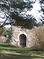
Chapel of the Priory of Berneçay
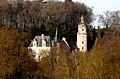
Les Roches-Saint-Quentin castle

Manor house of Le Bout-du-Pont
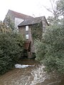
Mill


literature
- Le Patrimoine des Communes d'Indre-et-Loire. Flohic Editions, Volume 2, Paris 2001, ISBN 2-84234-115-5 , pp. 860-862.