La Celle-Guenand is a commune in the French department of Indre-et-Loire in the region of Center-Val de Loire . It belongs to the Arrondissement of Loches and the Canton of Descartes . It borders in the north-west on Paulmy , in the north on Ferrière-Larçon and Betz-le-Château , in the north-east on Saint-Flovier , in the east on Charnizay , in the south on Le Petit-Pressigny and in the south-west on Le Grand-Pressigny .
Population development
| year
|
1962
|
1968
|
1975
|
1982
|
1990
|
1999
|
2008
|
2015
|
| Residents |
543 |
509 |
420 |
365 |
412 |
362 |
385 |
375
|
Attractions
- Castle from the 15th century, restored in the 19th century, Monument historique
- Notre-Dame Church, built in the 15th and 16th centuries Century, restored in the 19th century, Monument historique
- Former chapel from the 15th century, Monument historique
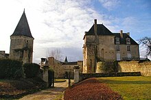
Castle of La Celle-Guenand
literature
-
Le Patrimoine des Communes d'Indre-et-Loire. Flohic Editions, Volume 1, Paris 2001, ISBN 2-84234-115-5 , pp. 538-541.
Web links


