Archfeld
|
Archfeld
Municipality Herleshausen
Coordinates: 51 ° 2 ′ 30 ″ N , 10 ° 8 ′ 47 ″ E
|
|
|---|---|
| Height : | 382 (360–387) m above sea level NHN |
| Area : | 6.17 km² |
| Residents : | 121 |
| Population density : | 20 inhabitants / km² |
| Incorporation : | 1st December 1970 |
| Postal code : | 37293 |
| Area code : | 05654 |
|
View of the place
|
|
Archfeld is a district of the municipality of Herleshausen in the Werra-Meißner district in northern Hesse .
geography
The village is located on the Ringgau , the southern high plateau of the low mountain range.
history
The place was first mentioned in 1279. Before the secularization , the village was owned by the Fulda monastery . Then it came into the possession of the Treusch von Buttlar family , who also owned the neighboring Altefeld as a fief . Many residents died in the turmoil of the Thirty Years' War and the plague.
On December 1, 1970, as part of the regional reform in Hesse, the municipalities of Altefeld, Archfeld, Breitzbach, Herleshausen (with Frauenborn), Holzhausen, Markershausen, Nesselröden, Unhausen, Willershausen and Wommen voluntarily merged to form the larger municipality of Herleshausen.
politics
The mayor is Karlheinz Deist.
Culture and sights
Johanneskirche
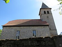
The Protestant church rises on the highest place of the place. It is believed that it originally served as a fortified church where the population could find refuge in times of need. There is nothing left of the original church building. The oldest part is the nave from 1567. The church tower was built in 1903 after the original was destroyed by fire. Inside there is a simple hall with a closing round barrel . Like the tower, the furnishings date from 1903.
As part of a festive parish church service on the occasion of its 450th anniversary , the village church was named "Johanneskirche" because twenty years earlier a new church bell named "Johannesglocke" was hung in the tower.
Because of its artistic, historical and urban significance, the church is a protected cultural monument .
Village green
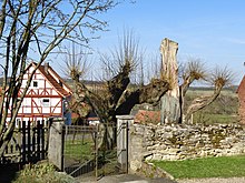
Below the church is the village green with two linden trees , the age of which is estimated to be 300 to 450 years. The art historian and photographer Thomas Wiegand suspects in his book “Trees from the Werraland” that the planting date of the two old trees might coincide with the construction of the church in 1567, when the Lords of Treusch-Buttlar set up shop in their newly acquired village. Perhaps they were also planted after the renovation of the church, which was destroyed in the Thirty Years War , in 1657.
At the former court and assembly center, jurisdiction was held by the Fulda monastery until 1539, and then by the noble court of Treusch von Buttlar. In the field in front of the churchyard wall, all matters of minor and embarrassing jurisdiction were negotiated, from the settlement of property issues to judgments of murder and manslaughter.
As one of the best preserved areas in the district, the complex is worth preserving as a cultural monument for reasons of local history. The two old Archfeld village linden trees are specially protected as natural monuments.
literature
- Monument topography Federal Republic of Germany. - Cultural monuments in Hessen. Werra-Meißner district I, old district Eschwege . Peer Zietz in collaboration with Thomas Wiegand, Braunschweig; Wiesbaden: Vieweg. 1991. ISBN 3-528-06240-1 . P. 126 f.
- Literature about Archfeld in the Hessian Bibliography
Web links
- Archfeld. In: website. Herleshausen community
- Archfeld, Werra-Meißner district. Historical local dictionary for Hessen. In: Landesgeschichtliches Informationssystem Hessen (LAGIS).
- Search for Archfeld in the archive portal-D of the German Digital Library
Individual evidence
- ^ Archfeld. In: website. Herleshausen community, accessed in September 2019 .
- ↑ Information on the districts. (No longer available online.) In: Internet presence of the Herleshausen community. Archived from the original on October 30, 2016 ; accessed on February 16, 2017 . Info: The archive link was inserted automatically and has not yet been checked. Please check the original and archive link according to the instructions and then remove this notice.
- ^ Archfeld, Werra-Meißner-Kreis. Historical local dictionary for Hessen. In: Landesgeschichtliches Informationssystem Hessen (LAGIS).
- ↑ Merger of the communities of Altefeld, Archfeld, Breitzbach, Herleshausen, Holzhausen, Markershausen, Nesselröden, Unhausen, Willershausen and Wommen in the district of Eschwege to form the new community "Herleshausen" on December 1, 1970 . In: The Hessian Minister of the Interior (Ed.): State Gazette for the State of Hesse. 1970 No. 51 , p. 2381 , item 2384 ( online at the information system of the Hessian state parliament [PDF; 7.5 MB ]).
- ^ Federal Statistical Office (ed.): Historical municipality directory for the Federal Republic of Germany. Name, border and key number changes in municipalities, counties and administrative districts from May 27, 1970 to December 31, 1982 . W. Kohlhammer, Stuttgart / Mainz 1983, ISBN 3-17-003263-1 , p. 388 .
- ↑ Mayor Archfeld. In: Website of the municipality of Herleshausen. Retrieved August 15, 2018 .
- ↑ Monument topography Werra-Meißner-Kreis IS 126 f.
- ↑ Thomas Wiegand: Trees from the Werraland - A photo documentation . Published by the Kreissparkasse Eschwege, 1984. P. 96 f.
- ^ Lindenplatz in Archfeld. Courts in Hesse. (As of February 17, 2016). In: Landesgeschichtliches Informationssystem Hessen (LAGIS).


