
Josthof
|
Josthof
community Gerstungen
Coordinates: 50 ° 54 ′ 7 ″ N , 10 ° 9 ′ 41 ″ E
|
|
|---|---|
| Height : | 275 m above sea level NN |
| Incorporated into: | Marksuhl |
| Postal code : | 99834 |
| Area code : | 036925 |
 Josthof in the south of the municipality
|
|
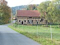
 Partial view (2008)
|
|
The Josthof is a district of the Gerstungen municipality in the Wartburg district in Thuringia .
location
The Josthof is located about three kilometers southwest of the local area of Marksuhl and about eleven kilometers (as the crow flies ) from the district town of Bad Salzungen . The Josthof is located in a wooded area on the Mölmesbach, a left tributary of the Suhl . There is a small fish pond at the height of the locality.
history
The Josthof belongs to a group of courtyards and small settlements ( Baueshof , Clausberg , Lutzberg , Kriegersberg , Hütschhof , Frommeshof , Rangenhof , Meileshof , Mölmeshof , Lindigshof and others) that have been in the domain of the Frankenstein counts and their home monastery Frauensee in the Buntsandstein- Hill country near Marksuhl were founded. Not far south of the village is the site of a destroyed medieval Siechenhof chapel St. Justus , which apparently contributed to the founding of today's Josthof.
traffic
The Josthof is located on the local connection road Baueshof - Mölmeshof - Josthof, which branches off from Landstraße 1023 at the Baueshof. There is no direct bus connection to the Josthof. The nearest stop is at the building's yard, it is part of the L-52 bus on the Eisenach –Förtha – Marksuhl – Berka / Werra – Dankmarshausen – Großensee bus operated by the Wartburgkreis transport company.
Culture and sights
- The Josthof is located on the ecumenical pilgrimage route in the section from Eisenach via Frauensee, Vacha to Bad Hersfeld and Fulda .
- The varied landscape is ideal for adventure tourism. The Circle M Ranch has been located at Josthof since the 1990s - a family business specializing in horse riding tourism.
- The Posteiche is a well-known natural monument on the way to Frauensee.
Josthof, location

Location of the St. Justus Chapel
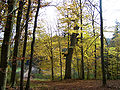
The Posteiche on the way to Frauensee
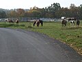
At the CIRCLE-M ranch


literature
- Erich Winter: The village settlements of the Eisenacher Land between Werra, Hainich and Thuringian Forest . Jena 1932, p. 78 .
- W. Döpel: History of Marksuhl , printing and publishing house of the Hofbuchdruckerei Eisenach H. Kahle, Eisenach 1909
Web links
Individual evidence
- ↑ Official topographic maps of Thuringia 1: 10,000. Wartburgkreis, district of Gotha, district-free city of Eisenach . In: Thuringian Land Survey Office (Hrsg.): CD-ROM series Top10 . CD 2. Erfurt 1999.
- ↑ Erich Winter The village settlements of the Eisenacher Land between Werra, Hainich and Thuringian Forest . Jena 1932.

Burkhardtroda | Eckardtshausen with Wilhelmsthal | Förtha with Epichnelles | Gerstungen with Untersuhl and Lutzberg | Leeks | Lindigshof | Marksuhl with Baueshof , Josthof , Meileshof and Mölmeshof | Neustädt | Oberellen with Clausberg , Frommeshof and Hütschhof | Sallmannshausen | Unterellen | Wolfsburg-Unkeroda