Burkhardtroda
|
Burkhardtroda
community Gerstungen
Coordinates: 50 ° 53 ′ 42 ″ N , 10 ° 14 ′ 1 ″ E
|
|
|---|---|
| Height : | 277 (275-300) m |
| Area : | 6.16 km² |
| Residents : | 345 (Dec. 31, 1997) |
| Population density : | 56 inhabitants / km² |
| Incorporation : | March 8, 1994 |
| Incorporated into: | Marksuhl |
| Postal code : | 99834 |
| Area code : | 036925 |
|
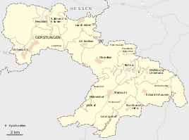
Burkhardtroda in the south of the municipality
|
|
|
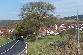
Partial view from the south (2006)
|
|
Burkhardtroda is a part of the Gerstungen community in the Wartburg district in Thuringia .
location
Burkhardtroda is located three kilometers east of Marksuhl on the western slope of the Milmesberg . The local area has a size of about 616 hectares, of which about 250 hectares are forest, and the rest is agricultural land, mainly grassland, but also arable land.
history
Since 1306 the place belongs to the parish Marksuhl. The Cistercian convent Frauensee near Bad Salzungen and the Eisenach Dominican monastery had properties in Burkhardtroda.
The place, first mentioned in 1306, has belonged to Marksuhl since March 8, 1994 . Marksuhl was incorporated into Gerstungen on July 6, 2018.
Attractions
- Church of St. Annen , half-timbered church from the 18th century
- The oldest still existing and used residential building is a half-timbered house from 1606.
Individual evidence
- ↑ Official topographic maps of Thuringia 1: 10,000. Wartburgkreis, district of Gotha, district-free city of Eisenach . In: Thuringian Land Survey Office (Hrsg.): CD-ROM series Top10 . CD 2. Erfurt 1999.
- ^ Thuringian ordinance on the dissolution of the municipality of Burkhardtroda and its incorporation into the municipality of Marksuhl of February 18, 1994 (GVBl p. 242)
- ↑ Thuringian Law and Ordinance Gazette No. 7 2018 of July 5, 2018 , accessed on July 6, 2018
Web links
Commons : Burkhardtroda - collection of images, videos and audio files
- Private homepage for Burkhardtroda (not available)


