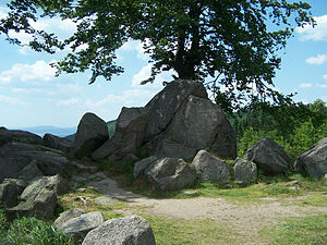
Bell ringer (mountain)
| Bell ringer | ||
|---|---|---|
|
At the bell ringer |
||
| height | 702.5 m above sea level NHN | |
| location | Ruhla , Thuringia , Germany | |
| Mountains | Thuringian Forest | |
| Dominance | 1.5 km → Gerber stone | |
| Notch height | 55 m ↓ Glasbachstein (confluence L 1027 / L 2119) | |
| Coordinates | 50 ° 51 '46 " N , 10 ° 22' 27" E | |
|
|
||
| Type | Rock peaks | |
| rock | granite | |
| Age of the rock | Paleozoic | |
The Glöckner , originally known as Klöckler , is a mountain with two rocky peaks and surrounding rocky seas and a popular vantage point on the Rennsteig in the Wartburg district in the Thuringian Forest .
Near the 702.5 m above sea level. NHN high rock group there are several inscriptions and monuments:
- the monument of the Ruhla forestry school - originally probably just a banal inscription dating an experimental planting “1813 was thought to have been planted here” - has been expanded to include the initials of some students and is located on the eastern elevation
- the founder of this Ruhla forest school, Oberforstrat Gottlob König , was honored with a rock seat on the western elevation - the "royal seat"
- The inscription "1813 was planted here" was probably already supplemented by the forestry students with the addition "for 1871". There was a lot of puzzling and speculation about the relationship between the two years. They cannot be associated with "patriodic feelings" after the unification of the empire, since the addition was mentioned in 1830 by Julius von Plänckner and in 1858 by Carl Grebe.
- At the request of the widow of the pedagogue Friedrich Fröbel , who died in the neighboring town of Marienthal , his name was carved on a granite stone as early as the 1860s
- a list of names for the Rennsteig club members who died in World War I and for Ludwig Hertel , the founder of the Ruhla club section who died in 1910, was carved on the western rock group
- Another granite stone bears the name of the Rennsteig researcher Elisabeth Streller (1879–1939)
After the southern slope around the mountain summit had been covered by dense spruce forest since the GDR era, hurricane Kyrill left extensive ground damage in early 2007 .
cards
- Topographic map 1:25 000: TK25 W - Ruhla and surroundings. Thuringian State Office for Surveying and Geoinformation, ISBN 3-86140-736-1 .
- Hiking map "green heart" 1: 30000, ISBN 3-929993-44-9 .
Individual evidence
- ↑ a b Map services of the Federal Agency for Nature Conservation ( information )
- ↑ Official topographic maps of Thuringia 1: 10,000. Wartburgkreis, district of Gotha, district-free city of Eisenach . In: Thuringian Land Survey Office (Hrsg.): CD-ROM series Top10 . CD 2. Erfurt 1999.
- ↑ Between Ruhla, Bad Liebenstein and Schmalkalden (= values of our homeland . Volume 48). 1st edition. Akademie Verlag, Berlin 1989, p. 61f.
- J. v. Plänckner: The Thuringian Forest. Gotha 1830.
- C. Grebe: The teaching forests of the Eisenacher forest school ... Eisenach 1858.


