
Gerberstein
| Gerberstein | ||
|---|---|---|
 |
||
| height | 728.5 m above sea level NN | |
| location | Thuringia , Germany | |
| Mountains | Thuringian Forest | |
| Dominance | 1.6 km → Great Weissenberg | |
| Notch height | 40 m ↓ Hirschbalzwiese | |
| Coordinates | 50 ° 51 '34 " N , 10 ° 23' 36" E | |
|
||
| Type | Rock peaks | |
| rock | granite | |
| Age of the rock | Paleozoic | |
| particularities | "Oldest" mountain in Thuringia | |

The Gerberstein is one of the highest mountains in the Wartburg district .
The 728.5 m above sea level. NN high granite formation in the Thuringian Forest has a viewing platform with a view of the Werra Valley and the Rhön . The closest communities are Ruhla , Steinbach (Bad Liebenstein) and Brotterode .
The Gerber stone consists of the main granite of Ruhlaer saddle which in the extraction pressure in the Saxonian Bruchschollentektonik the weathering resistance best.
history
The Gerberstein is the first mountain of the entire ridge area of the Thuringian Forest mentioned in a document. It was mentioned as Gervuenestein in a boundary description of the Mark Breitungen of King Heinrich I in 933 . A few years later (1014) he appeared as Gerwinestein in a border description of the Mark Lupnitz . There was probably a castle on the mountain - but no remains of any fortifications can be seen.
The Gerberstein belonged to the Ludowinger hunting area , at that time there were still brown bears as game hunting.
natural reserve
A notice board on the main access road informs that the Gerberstein has been protected as a natural monument since 1940. The BUND - district association Wartburgkreis designated the Gerberstein as biotope of the month December 2000 .
Forest cover
In the summit area, old beech trees are predominant, interspersed with sessile oak , mountain ash and sycamore maple . The lower layers have also been planted with spruce for 200 years in the hope that they will still be able to achieve forest management success in the exposed location. The Gerberstein has also been hit by hurricanes in recent years .
Ground vegetation
Forest equestrian grass , Harz bedstraw , whorleaf white root and a typical cross-section of mosses , ferns and lichens dominate the herb and soil layer .
Bird life
Between 1979 and 1984 ornithologist Robert Neugebauer documented a so-called "control area". The following 14 bird species were observed in the area, which was mainly planted with spruce trees : The dominant species were chaffinches , robins , dunnock and golden cockchafer . The common warbler , wood warbler , willow warbler , crested tit , coal tit , great tit , blackcap , blackbird , song thrush and starling were recorded with occasional presence .
Attractions
In the immediate vicinity are the Erbstromquelle , the Goldborn , the Glasbach desert and the striking Glasbachstein intersection . About 1 km to the south is the Luther memorial at the traditional site of Martin Luther's capture .
Impressions
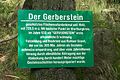
Information board

Rock formations
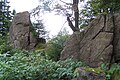
Rock formations

Rock formations


literature
- Topographic map 1:25 000: TK25 W - Ruhla and surroundings , Thuringian State Office for Surveying and Geoinformation, ISBN 3-86140-736-1
- Hiking map “green heart” 1: 30000, ISBN 3-929993-44-9
Web links
Individual evidence
- ↑ Official topographic maps of Thuringia 1: 10,000. Wartburgkreis, district of Gotha, district-free city of Eisenach . In: Thuringian Land Survey Office (Hrsg.): CD-ROM series Top10 . CD 2. Erfurt 1999.
- ↑ Between Ruhla, Bad Liebenstein and Schmalkalden (= values of our homeland . Volume 48). 1st edition. Akademie Verlag, Berlin 1989.
- ↑ Klaus Fink: The Gerberstein. Biotope of the month December 2000 . In: MFB Verlagsgesellschaft mbH Eisenach (ed.): StadtZeit. City journal with information from the Wartburg district. January issue. Druck- und Verlagshaus Frisch, Eisenach 2001, p. 36-38 .