Steinbach (Bad Liebenstein)
|
Steinbach
City of Bad Liebenstein
|
|
|---|---|
| Coordinates: 50 ° 50 ′ 0 ″ N , 10 ° 22 ′ 0 ″ E | |
| Height : | 390 m |
| Area : | 15.6 km² |
| Residents : | 1185 (December 31, 2011) |
| Population density : | 76 inhabitants / km² |
| Incorporation : | December 31, 2012 |
| Postal code : | 36448 |
| Area code : | 036961 |
|
Location of Steinbach in Bad Liebenstein
|
|
|
The Steinbacher Church
|
|
Steinbach is a mountain village and part of the town of Bad Liebenstein in the Wartburg district in Thuringia . Steinbach is known, among other things, for the capture of Martin Luther above the village in 1521.
geography
Steinbach is located in the north-western Thuringian Forest . The small settlement Atterode belongs to the district .
mountains
The Great Weissenberg, a hill on the Rennsteig with the border point Dreiherrenstein, is the highest point in the village and the district . Also noteworthy are: Rennwegskopf ( 729.6 m above sea level ), Gerberstein ( 728.5 m above sea level ), Golmerskopf ( 684.7 m above sea level ), Eselskopf ( 600.5 m above sea level ), Scharfenberg ( 572.6 m above sea level ), Seifertsberg ( 484.5 m above sea level ) and Mühlbergskopf ( 340.2 m above sea level ).
Waters
In the northern part of the district, the ridge of the Thuringian Forest and the Rennsteig form the natural watershed. The springing at the Franconia meadow at Black Mountain Erbstrom flows towards Ruhla and the north Hörsel to. The Steinbach with Kallenbach and Glasbach are the northern source streams of the Grumbach , which flows into the Werra below Breitungen / Werra . To the south of the village, near a pond at the Hubertushof forest inn, there is the “drinks hole” - an episodic funnel spring - belonging to the headwaters of the Grumbach. The Lutherborn and Triniusquelle springs, which are of historical importance, are also worth mentioning.
history
The first written mention of Steinbach comes from August 10, 1330 . The place was in the domain of Liebenstein Castle in the Altenstein office . Today's district also includes the Glasbach desert , a small settlement of miners and forest farmers in the ridge area of the Thuringian Forest, which was already important around the year 1000. Cutlers and blade grinders, miners, charcoal burners and forest farmers shaped the development of Steinbach. Up until the end of the 19th century, iron ore and manganese were mined in the Atterode district, and the mineral fluorite until 1990 . Numerous remains of pings and tunnels as well as geological features are made accessible by circular hiking trails. The field name Schleifkothengrund refers to the flourishing production of knife blades and small iron goods by the blade grinders in the village. The place was called Messersteinbach for centuries, around 1800 there were still around 130 cutlers and 80 locksmiths workshops, at that time there was already a traditional connection and division of labor with the neighboring towns of Ruhla and Brotterode .
Another forest trade - the resin scraping - was operated in the forests around the forest location Krätzersrasen, it served to extract tree resins, from which pitch and other natural products can be produced.
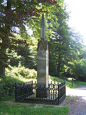
A regional ethnographic peculiarity in Steinbach was the staff justice - a traditional legal form of the lower jurisdiction , derived from the tribal law of the Thuringians , which regulated the affairs in the village up to 1898. Steinbach gained fame through the apparent kidnapping of Martin Luther on May 4, 1521, and a memorial not far from the Rennsteig commemorates this event.
In a 1726 required inspection of the place by mining officials Duchy of Saxe-Meiningen were great injustices and exploitation noticed in the woods, the 1732 enacted Bergordnung led in 1750 to a remarkable flowering of mining and iron industry. Numerous buildings in Steinbach were destroyed by a large fire in 1732. The reconstruction took place quickly, in 1734 a school house and in 1736 the church was consecrated. The adjacent mountain cemetery on the steep slope above the church still has some baroque grave monuments that are well worth seeing.
The transition to industrial mass production of iron goods in the late 19th century, which was carried out elsewhere, had dramatic economic and social consequences for the still handicraft-oriented Steinbachers, the population became impoverished and the Steinbach Revolution finally broke out in August 1907 , a riot caused by the Sachsen-Meininger Authorities were persecuted with great severity as a breach of the peace . In 1948, more than 500 workers and 45 miners were still working in the metal industry in Steinbach.
The weapons depots from the Second World War , hidden in the Steinbach forests, led to a large-scale action by the GDR security authorities in Steinbach and the surrounding area in 1968, with raids and arrests and weeks of interrogation of almost all residents. A conspiracy against Walter Ulbricht was allegedly uncovered, and several Steinbach residents were sentenced to long prison terms in show trials.
In 1955 there were 2305 inhabitants in the place, in 1984 there were still around 1800 inhabitants, there were around 1000 industrial jobs. In VEB steel and cutlery knives, cutlery and steel products were produced. The company Elektroinstallation Ruhla also had a branch in the village. The agricultural areas were already farmed with grazing cattle in the GDR by LPG Barchfeld. Every year around 4,000 holidaymakers found accommodation in the FDGB holiday home Volkshaus and in company holiday homes .
Since 2000 there have been plans to merge the municipalities of Bad Liebenstein, Schweina and Steinbach. On November 2, 2011, the mayors of the three municipalities signed a contract for the formation of a unified municipality . On December 31, 2012, Bad Liebenstein, Schweina and Steinbach merged to form the new town of Bad Liebenstein.
Population development
Development of the population:
|
|
|
- Data source: from 1994 Thuringian State Office for Statistics - values from December 31st
politics
Municipal council
The last local council of Steinbach consisted of 12 council members.
(As of: local elections on June 7, 2009)
mayor
In 2009 Steffen Müller was elected mayor , who held this office until the Steinbach community was dissolved. With the incorporation of the place into the city of Bad Liebenstein, Müller became mayor of the district .
Culture and sights
Events
The election ceremony will take place on January 2nd , in the local dialect "Walfier". The background for this festival is the annual reassignment of the offices and rights in the place, the new officials had to cover the costs of the celebrations. The fair in Steinbach takes place annually on five days (Thu – Mon) in mid-October and is the cultural highlight of the year in the region.
Collection of notes in the Steinbach parish archive
In the Steinbach parish archives there is a collection of almost 200 compositions from the 18th and early 19th centuries, in which works a. a. by Wolfgang Amadeus Mozart , Joseph Haydn and Ignaz Pleyel are included. A large part of the collection, however, is made up of four-part vocal works by church music that have been handed down anonymously and that were used in Steinbach during the 18th century, for example at funerals. The collection is very heterogeneous and was apparently brought together by different people. An arrangement of Joseph Haydn's The Creation by the Meiningen clarinetist and court musician Carl Andreas Göpfert is even likely to be an autograph . In the early 19th century, Göpfert was responsible for bath music in Bad Liebenstein . For the Early Music Festival in Thuringia - Güldener Herbst, works from the Steinbach music collection will be performed for the first time on October 7, 2017 in the Steinbach Baroque Church.
Johann Jakob Bach and Johann Ludwig Bach
Between 1679 and 1690 the organist Johann Jakob Bach (1655–1718) , who came from Thal near Ruhla , lived and worked in Steinbach. His son Johann Ludwig (1677–1731), the so-called "Meininger Bach", spent a large part of his childhood in Steinbach (from 1679 to 1688) and in 1711 became court conductor at the court of Saxony-Meiningen . Unfortunately no compositions by Johann Jakob Bach have survived. Johann Sebastian Bach held his cousin Johann Ludwig in high esteem and even performed his motets in Leipzig .
sport and freetime
There is an older ski jumping facility in Steinbach. There are numerous hiking trails around the village, and in winter there are cross-country trails available when there is enough snow.
Motorsport
From 2011, the legendary Glasbach race (1973-1992) was revived under the patronage of ADAC on the winding section of Landstrasse 1027 . The race track leads from the entrance to Steinbach over 5.5 km and 260 m difference in altitude to the intersection with the L 1127 the so-called Glasbach up to the Rennsteig .
Attractions
- Steinbach baroque church from 1736 with Steinbach mountain cemetery
- Steinbach local history museum
- Luther beech / Luther monument
- Dreiherrnstein am Rennsteig
- Ground monument of the deserted Glasbach am Rennsteig
- Forsthaus Krätzersrasen
- Ski jumps in the Schleifkotengrund
- Gerberstein , the highest point in the Wartburg district
- Questenstein, lookout point on the Breitener Rennsteig hiking trail
- Trinius Spring
Economy and Infrastructure
Economic development
After 1990 the mining was stopped. The inhabitants of Steinbach are mainly employed in the neighboring towns of Bad Liebenstein, Bad Salzungen and Ruhla.
Established businesses
- Messerhaus Schleifkotengrund GmbH
- Stöcker Schneidwaren GmbH & Co. KG
traffic
Road traffic
Steinbach can be reached via Landstrasse 1027 from Ruhla and Bad Liebenstein . The nearest motorway junctions of A 4 are about 18 kilometers away terminals 40b Sättelstädt and 40a Eisenach -Ost .
Rail transport
There are stops on the Werra Railway in Immelborn, Bad Salzungen and Breitungen . There is a connection to the Intercity and ICE network of Deutsche Bahn in Eisenach. Before 1970 there was also a railway line from Bad Liebenstein to Steinbach . The train station in Steinbach ended at the lower entrance to the town, in Bad Liebenstein the train station was on the current bypass.
Transportation
The following bus lines run by the Verkehrsgesellschaft Wartburgkreis mbH run to Steinbach:
| line | Driving distance |
|---|---|
| L-71 | Eisenach - Seebach - Ruhla - Steinbach - Schweina - Barchfeld - Bad Salzungen |
| L-106 | Steinbach - Bad Liebenstein - Schweina - Barchfeld - Bad Salzungen |
| L-107 | Bad Salzungen - Bad Liebenstein - Steinbach - Brotterode - Tabarz |
| L-133 | Bad Liebenstein - Steinbach - Schweina - Bad Liebenstein |
In addition to its importance for the transport of schoolchildren, bus transport is also important as a feeder to Eisenach train station and for the surrounding communities that are geared towards hiking tourism.
Personalities
- Sigrun Krause (born February 28, 1954 in Steinbach), cross-country skiing, Vice World Champion and bronze medal winner at the 1976 Olympic Games
literature
- Eduard Fritze : History about Bad Liebenstein, Schweina, Steinbach and Atterode . Edited by Holger Munkel. Reprint of the Eisenach edition, self-published by the author, 1925. Elch Verlag, Bad Liebenstein 1999, ISBN 3-933566-09-6 .
- Between Ruhla, Bad Liebenstein and Schmalkalden (= values of our homeland . Volume 48). 1st edition. Akademie Verlag, Berlin 1989.
- Roland Geißler : hiking guide to Bad Liebenstein and the Inselsberg , Verlag Rockstuhl, Bad Langensalza 2007, ISBN 978-3-938997-79-6
Web links
Individual evidence
- ↑ a b Thuringian Land Surveying Office: Ruhla and surroundings ; Topographic map of the Thuringian Forest Nature Park, sheet 5128; Erfurt: Thuringia / State Office for Surveying and Geoinformation, 2005; ISBN 3-86140-736-1
- ↑ https://www.heimatfreundebali.de/heimatgeschichte/denkmale/kapelle-glasbach//
- ↑ Schäfer: Origin of iron processing .
- ↑ Schäfer: The Krätzers lawn
- ↑ Shepherd: The Walfier in Steinbach
- ^ Salzmann: Between Ruhla, Bad Liebenstein and Schmalkalden ; Pp. 62-66.
- ^ Schäfer: Steinbacher Revolution .
- ↑ Erler: Ulbricht assassin . See also Steinbach: The Assassin's Village in SWR 2 Leben , broadcast on February 12, 2010.
- ^ Paul Luther: Materials for local history lessons - Bad Salzungen district, Suhl district . Ed .: Council of the Bad Salzungen District, Department of Public Education. Bad Salzungen 1959, structure of the district of Suhl (overview of the places and population of the districts), p. 5-11 .
- ^ Norbert Moczarski et al: Thüringisches Staatsarchiv Meiningen. Department of the Regional Economic Archive South Thuringia in Suhl . A brief inventory overview. Ed .: Thuringian State Archives Meiningen. 1st edition. Druckhaus Offizin Hildburghausen, 1994, Development of traditional industrial areas in South Thuringia until 1990, p. 16-24 .
- ^ Salzmann: Between Ruhla, Bad Liebenstein and Schmalkalden ; P. 64
- ↑ http://www.insuedthueringen.de/lokal/bad_salzungen/fwstzslzlokal/Gemeinsames-Oberland-Vertrag-unternahm;art83434,1797658 accessed on November 4, 2011
- ↑ Slight majority for 13 new municipalities called on November 27, 2012
- ↑ StBA: Area changes from January 1st to December 31st, 2012
- ↑ Local elections in Thuringia on June 7th, 2009. Elections for community and city council members. Preliminary results. (PDF; 1.9 MB) The State Returning Officer, accessed on February 6, 2010 .
- ↑ Cf. the entry D-STBp for the Steinbach parish archive in the online catalog of the International Sources Lexicon for Music RISM: http://opac.rism.info/
- ↑ Archived copy ( memento of the original dated August 3, 2015 in the Internet Archive ) Info: The archive link was inserted automatically and has not yet been checked. Please check the original and archive link according to the instructions and then remove this notice.
- ↑ District Office Wartburgkreis (ed.): Wartburgkreis - Thuringia ; Suhl 2008; P. 43.
- ^ Thuringia / State Office for Surveying and Geoinformation: Overview map 1: 250000 Thuringia ; Erfurt: TLVermGEO, 2005; ISBN 978-3-86140-221-3 .
- ↑ Verkehrsgesellschaft Wartburgkreis mbH - timetable


