Sättelstädt
|
Sättelstädt
Municipality Hörselberg-Hainich
Coordinates: 50 ° 56 ′ 37 ″ N , 10 ° 28 ′ 49 ″ E
|
|
|---|---|
| Height : | 263 m |
| Area : | 5.79 km² |
| Incorporation : | January 1, 1996 |
| Incorporated into: | Hörselberg |
| Postal code : | 99820 |
| Area code : | 03622 |
|
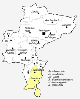
Location of Sättelstädt in Hörselberg-Hainich
|
|
|
View from the north (2011)
|
|
Sättelstädt is a district of the Thuringian municipality Hörselberg-Hainich in the Wartburg district .
geography
Sättelstädt is in the east of the Wartburg district, about 15 kilometers east of Eisenach in the Hörsel valley on the southeastern slope of the Hörselberge . In Sättelstädt the Emse flows into the Hörsel.
history
Sättelstädt is first mentioned in a document dated December 30, 1015 or 1018 as a Setinstete . This emperor is Henry II. The monastery of Fulda the wild spell in the Thuringian Gau and Mark Lupenzo (to Großenlupnitz ). The place belonged between 1458 and 1837 to the Uetterodtschen court (from 1640 in the Duchy of Saxe-Gotha ).
Sättelstädt was the seat of the Sättelstädt administrative association from 1991 to 1995 . The incorporation to Hörselberg took place on January 1, 1996; Hörselberg went on in 2007 in the municipality of Hörselberg-Hainich.
Economy, infrastructure and transport
The federal motorway 4 runs east of the place with the junction Sättelstädt , from which the federal road 7 leads in the direction of Gotha . Landstrasse 3007 connects Sättelstädt with Wutha-Farnroda and Eisenach in the west and the A4 and B7 in the east. The Thuringian Railway runs through the town with a stop for regional traffic.
Attractions
- Probably the most important sight of the place is the Johanneskirche (in the picture left front). It holds u. a. two very beautiful bells from 1646, weighing 556 kg and 340 kg respectively.
Daughters and sons of the church
- Georg Heinrich Lux (1779–1861), school teacher, organist and composer
- Dagmar Schipanski (born September 3, 1943), scientist and politician (CDU)
Web links
Individual evidence
- ↑ Official topographic maps of Thuringia 1: 10,000. Wartburgkreis, district of Gotha, district-free city of Eisenach . In: Thuringian Land Survey Office (Hrsg.): CD-ROM series Top10 . CD 2. Erfurt 1999.
- ↑ Dr. August Beck: Die Geschichte des Gothaischen Land , Volume I, Geschichte der Regenten, Gotha, 1868. S. 38


