Kindel (industrial area)
|
Kindel industrial area
(Künkelhof) Municipality Hörselberg-Hainich
Coordinates: 51 ° 0 ′ 7 ″ N , 10 ° 26 ′ 49 ″ E
|
|
|---|---|
| Height : | 330-350 m above sea level NN |
| Area : | 1.2 km² |
| Incorporated into: | Hörselberg |
| Postal code : | 99820 |
| Area code : | 036920 |
|
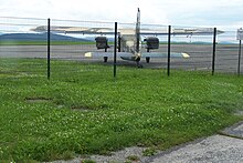
Eastern approach from the airfield (2012)
|
|
The Kindel industrial area is an industrial area in the Thuringian municipality of Hörselberg-Hainich in the Wartburg district . The site emerged from the Künkelhof small settlement and a civilian settlement that was created after the Second World War and was evacuated by 1992 on the edge of the Kindel military training area of the Red Army (with a tank firing range and military airfield).
location
The Kindel industrial area is located in the center of the Hörselberg-Hainich municipality, about 8 km northeast of Eisenach in the part of the former Kindel military training area east of Bundesstraße 84 between the districts of Wenigenlupnitz and Wolfsbehringen. Since January 2010 the BAB 4 has been running immediately south of the industrial area. The nearest junction is about two kilometers away at Großenlupnitz and is also the junction with the B 84 to Eisenach, Behringen and Bad Langensalza . Today's Eisenach-Kindel airfield is located on the eastern edge of the industrial area.
history
The Künkelhof was first mentioned as Cancul in October 1080. Before the beginning of the Second World War , an approximately 300 hectare military training area was built at the Künkelhof. The military area initially served as a testing and shooting range for artillery pieces manufactured in Eisenach . After the war, the Kindel firing range was expanded and handed over to the group of the Soviet armed forces in Germany as a tank firing range. Fixed accommodations (barracks and stone buildings) were built for the regular crew and their family members on the approximately 700 hectare site of the Kindel forest settlement , while the units arriving for training had to live in tents and camouflaged earth pits under conditions at the front. After the military had left and the area had been decontaminated, the Kindel industrial area was developed with the help of the Thuringian State Development Corporation. The site was chosen because of airport operations and is bordered to the west by the nature reserve, now part of the UNESCO World Heritage beech and Ancient Beech Forests of the Carpathians and other regions of Europe counted Hainich National Park . In the mid-1990s, high-voltage lines and two gas lines were laid on the southern slope of the Nesse valley ; they were a prerequisite for the establishment of industry. In 2009, with the relocation of the motorway to the Kindel, the road traffic connection was also optimized.
The industrial area has now reached a size of 120 hectares, in the final stage 620 hectares may be available. Automotive suppliers determine the appearance.
particularities
The Kindel industrial area has some special features.
- The airfield and adjacent areas are used for trade fairs, concert events and major sporting events. One of the highlights is the annual airfield festival with demonstrations and presentations by aircraft veterans, including a regular “ Aunt Ju ”.
- Since 2004, commercial, privately organized car racing events have been held several weekends a year on the part of the airfield not used for aviation. Since 1992, the Thuringian Driving Safety Center has been offering driving safety exercises and courses for professional drivers and private individuals at the same location . The Kindel has also developed as a venue for trade fairs (garden and agricultural products) and air shows .
- Special wheel loaders for mining are manufactured on the Kindel and can be viewed on the company's outdoor area.
- To the east of the airfield, on the former route of the Nessetalbahn, the Nessetal-Radweg joins, which, when completed, will connect the Nessetal from Behringen to Erfurt .
- Part of the former military area north of the tank farm at the airfield has been converted into a biotope . Here, hikers have the opportunity to take a look at the southeastern edge of the Hainich National Park. The hiking trail continues in an easterly direction to Hainaer Holz with three wall castles and a listed mill in the Nessetalgrund.
Transport links
Two kilometers from the airfield is the Eisenach Ost junction of the A 4 near Großenlupnitz , which can be reached via the B 84 . Local public transport is served by a bus from the Wartburgkreis transport company .
Web links
Individual evidence
- ↑ Eisenach / Kindel industrial area. (No longer available online.) In: Standortmanagement Thüringen. Archived from the original on March 5, 2014 ; Retrieved July 30, 2011 . Info: The archive link was inserted automatically and has not yet been checked. Please check the original and archive link according to the instructions and then remove this notice. (As of 1998)
- ^ Wolfgang Kahl: First mention of Thuringian towns and villages. A manual. Rockstuhl Verlag, Bad Langensalza, 2010, ISBN 978-3-86777-202-0 , page 155
- ↑ (eol / rbr): Dump trucks come from the Kindel. WartburgkreisOnline, June 12, 2003, accessed on September 6, 2011 : “Reinhold Stanitzek from the Thüringer Landesentwicklungsgesellschaft praised the location near Eisenachs. Eight companies have settled on the former military training area. LEG spent 19 million euros to develop the site. 1400 jobs were created and the companies invested around 300 million euros. "
- ↑ District Office Wartburgkreis (Ed.): Leisure guide through the Wartburgkreis and the city of Eisenach . Bad Salzungen 1999, p. 49 .
- ^ "Demopark" 2005 on the Kindel. WartburgkreisOnline, March 3, 2004, accessed on September 6, 2011 .
- ^ Verkehrsgesellschaft Wartburgkreis mbH - VGW route directory ( Memento from January 9, 2004 in the Internet Archive )


