Beuernfeld
|
Beuernfeld
Municipality Hörselberg-Hainich
Coordinates: 51 ° 0 ′ 37 ″ N , 10 ° 24 ′ 8 ″ E
|
|
|---|---|
| Height : | 252 m above sea level NN |
| Area : | 2.64 km² |
| Residents : | 124 |
| Population density : | 47 inhabitants / km² |
| Incorporation : | February 25, 1994 |
| Incorporated into: | Grossenlupnitz |
| Postal code : | 99820 |
| Area code : | 036920 |
|
Location of Beuernfeld in Hörselberg-Hainich
|
|
|
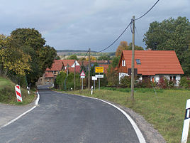
Town view from the east
|
|
Beuernfeld is a district of the Thuringian municipality Hörselberg-Hainich in the Wartburg district .
geography
The place Beuernfeld is about eight kilometers as the crow flies northeast of Eisenach on the southwest edge of the Hainich National Park . The historical location is in the valley of the Böber , on the eastern slope of the Nausterberg. The total area of the district is 2.64 km². Federal motorway 4 has been running just south of the town since 2010 .
history
The town of Beuernfeld on the upper reaches of the Böber was built around the same time as other towns ( Bolleroda , Bettelroda , Ettenrode , Hahnerode , Hötzelsroda and others) near a settlement on the western edge of the town that was already occupied from prehistoric times . Prehistoric and early historical finds have been documented from the Beuernfeld corridor since the 1930s; they came to light during field work on the Nausterberg and during a manual excavation in Stierengasse.
The place Beuernfeld was mentioned in 1265 as Berenfeldt , 1269 Bürnfeldt and 1364 Burnfeld as property of the Fulda monastery . In Großenlupnitz , three kilometers to the south-east, there has been an administrative seat of the monastery since Carolingian times and at the same time the administrative center of the Lupnitzgau.
In the 13th century, a noble family "von Bisa" built a manor in the local area of Beuernfeld, and a stone bower was also built there. The Eisenach Carthusian monastery acquired the place Beuernfeld from the Fulda monastery in 1414. The local aristocrats Petrus, Friedrich and Johann von Bisa renewed their feudal oath with the Fulda bailiff in 1423 and continued to serve as court lords over Beuernfeld. A conflict arose when the Carthusian monks wanted to get a land manager Hermann Kirchner through to drive the von Bisa out of Beuernfeld. As early as 1428 the Carthusians transferred the village to the Eisenach Marienstift as a pledge; this pledge ended in 1488.
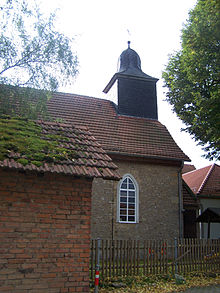
After the secularization of the Carthusian monastery, the Beuernfelder Gutshof was handed over to the noble von Harstall family from nearby Mihla as a princely fief. The Harstalls had previously acquired property in Berteroda, three kilometers to the northwest, from which a separate family branch emerged. When the Harstall fiefdom expired in Beuernfeld with the death of Ernst Christof von Harstall (zu Berteroda) in 1754, the ducal chamber estate Trenkelhof (then part of Großenlupnitz) was entrusted with the administration of Beuernfeld. 24 houses and farms in Beuernfeld were registered in the issued documents. The village church of Beuernfeld was renovated as early as 1713 and is still a small, modest building today. The interior consists only of a rectangular hall, without a choir arch or niche, which is vaulted by a flat "board barrel".
In 1879, based on the census of 1875, statistical information on the place Beuernfeld was published, the place had 29 houses and 125 inhabitants on the reference date. The size of the fields was 263.9 ha - of which courtyards and gardens 3.9 ha, meadows 19.1 ha, arable land 219.9 ha. Forest 1.1 ha, ponds, streams and rivers 3.5 ha. Trifte, wasteland and orchards accounted for 16.3 hectares. The livestock was 21 horses, 105 cattle, 355 sheep, 84 pigs and 23 goats. As a special feature 31 bee colonies are to be mentioned.
Beuernfeld farmers founded a type III LPG in the 1950s. The nearby military firing range of the Red Army on the Kindel existed until 1990 and worried the residents of the neighboring towns. On February 25, 1994, the communities of Beuernfeld and Bolleroda were incorporated into the community of Großenlupnitz. In 1996, Großenlupnitz and four other places formed the new municipality of Hörselberg , which on December 1, 2007 together with Behringen formed the current municipality of Hörselberg-Hainich.
After 1995, a row house settlement was built on the western edge of the village. The northward relocation of the autobahn route led to a "cutting up" of the village corridor, and the first wind turbines on the corridor border to Großenlupnitz and Hötzelsroda were also built during this time, two high-voltage lines and several gas lines were laid.
Economy, infrastructure and transport
Beuernfeld is a place characterized by agriculture, and they rely on gentle tourism. The closest motorway connection is about two kilometers away at Großenlupnitz. There is a connection to rail traffic in Eisenach. The industrial and commercial settlements of Eisenach and Hörselberg-Hainich as well as the Hainich National Park with its tourist infrastructure are within five kilometers.
Attractions
The village church was built in 1713 and replaced a 400 year old predecessor structure. In 1878 it was extensively renovated. The interior is a rectangular hall with a wooden barrel vaulted ceiling .
Web links
Individual evidence
- ↑ Official topographic maps of Thuringia 1: 10,000. Wartburgkreis, district of Gotha, district-free city of Eisenach . In: Thuringian Land Survey Office (Hrsg.): CD-ROM series Top10 . CD 2. Erfurt 1999.
- ↑ Paul Bottom, Rainer Lämmerhirt : deserted villages in Hainich area. West Thuringian Heimatschriften, Mihla 2001
- ^ Thuringian Museum Eisenach, Beuernfeld local file
- ^ Hermann Helmboldt: Beuernfeld . In: Georg Voss (Hrsg.): Architectural and art monuments of Thuringia. Grand Duchy of Saxony-Weimar-Eisenach. District Court District Eisenach. The country places . Booklet XL. Verlag Gustav Fischer, Jena 1915, ISBN 3-89557-143-1 , p. 31 .
- ^ C. Kronfeld: Regional studies of the Grand Duchy of Saxony-Weimar-Eisenach . Second part. Topography of the country. Hermann Böhlau, Weimar 1879, Beuernfeld, p. 31 .
- ^ Thuringian ordinance on the dissolution of the municipalities of Bolleroda and Beuernfeld and their incorporation into the municipality of Großenlupnitz of January 10, 1994 (GVBl. P. 221)
- ^ StBA: Changes in the municipalities in Germany, see 1996
- ^ StBA: Changes in the municipalities in Germany, see 2007
- ^ Voss, Georg (ed.): Grand Duchy of Saxony-Weimar-Eisenach. District Court District Eisenach. In: Lehfeldt, Paul / Voss, Georg (eds.): Building and art monuments of Thuringia. Booklet XL. Jena 1915 p.390 f.


