
Hötzelsroda
|
Hötzelsroda
City of Eisenach
Coordinates: 51 ° 0 ′ 36 ″ N , 10 ° 21 ′ 46 ″ E
|
|
|---|---|
| Height : | 296 (290-300) m |
| Area : | 7.93 km² |
| Residents : | 1367 (2018) |
| Population density : | 172 inhabitants / km² |
| Incorporation : | July 1, 1994 |
| Postal code : | 99817 |
| Area code : | 03691 |
 Location of Hötzelsroda in Eisenach
|
|
 The church in Hötzelsroda
|
|
Hötzelsroda has been a district of the independent city of Eisenach in Thuringia since 1994 .
geography
Geographical location
Hötzelsroda is naturally located in the Werrabergland-Hörselberge area , which includes the areas of the northern Eisenach urban area dominated by limestone slabs.
The historic town center is located in a natural depression of the Weihersbach , about four kilometers northeast of Eisenach. The terrain appears hilly and is heavily modeled. The highest elevations are the Eichberg (331 m) west of the Landstreit locality and the neighboring Schafberg (324 m). The waters of Erbsbach, Harsbach, Weihersbach and Himmelsbach originate in the district as source streams of the Böber and Holzbach. These streams are tributaries of the Nesse and flow off to the east. The Michelsbach rises in the western part of the district , an approximately 5 km long tributary of the Hörsel . Until it silted up in the 19th century, the Himmelsbacher See, which had no outflow, was in a natural depression.
The geographic height of the main town is 290 m above sea level. NN .
There are two smaller strips of wood at the Landstreit and Mittelhof farms . The Hötzelsroda corridor is mainly used for agriculture, but has also had larger industrial and commercial areas since the 1990s.
The neighboring towns of Hötzelsroda are in the south the city of Eisenach, in the west the Stregda district , in the north the Eisenach districts Neukirchen and Berteroda and the municipality Berka vd Hainich , in the east the districts Bolleroda , Beuernfeld and Großenlupnitz of the municipality Hörselberg-Hainich and in the southeast Eisenach district of Stockhausen .
traffic
The location is connected to the traffic network by the state road 1021 and the district roads K 2 and K 2a , which serve as a feeder to the federal motorway 4 , which runs just north of the location . The closest junction , Eisenach-Ost , is about two kilometers east of Großenlupnitz. Partly unpaved local connecting routes lead to Neukirchen, Berteroda and Bolleroda.
There is a railway connection at Eisenach station . The nearby Eisenach-Kindel airfield in the Wenigenlupnitz district serves regional air traffic .
history

Archaeological finds in the “Feuersteinland”, on the arable land to the east and west of the “settlement”, refer to settlement sites as early as the Neolithic . Today's district with partial loess soils also includes abandoned settlement areas at Gut Landstreit and at the Mittelhof. The earliest document on local history is a document dated March 20, 1143. The original place name "Hertelsroda" recalls the high medieval clearing of a forest by a "Hertel".
The historical location is laid out in the form of a street village.
The place belonged to the office of Creuzburg . In 1324 the von Kolmatsch family sold the village to the Nikolaikloster in Eisenach . As church patrons and owners of the "lower jurisdiction", the gentlemen von Reineck sat in Hötzelsroda in a representative half-timbered house, which was called "Schlösschen" and which stood next to the church. This presumably oldest house in the village (from the 16th century) was juxtaposed with a new building in the 19th century, in which the courtroom and a separate vault in the basement were used as a dungeon. The property was sold to a bidding group from the town in 1853 and divided up.
In 1414 income in Heezelsrade was transferred to the Eisenach hospital of Saint Elisabeth . Today's Hötzelsrodaer Church was built in 1716.
Hötzelsroda went down in German criminal history: the last execution by burning ( pyre ) took place on July 13, 1804 ; the convicted was a resident of Hötzelsroda who was arrested in Eisenach and who had previously been noticed several times as an arsonist . In 1844, the Eisenach family of textile manufacturers, the Eichel family, acquired the neighboring Dürrerhof manor house .
During the Franco-Prussian War of 1870–71 , 21 residents from Hötzelsroda lost their lives. A plaque on the church and a separate memorial stone commemorate these victims.
In 1879, based on the census of 1875, statistical information on all places in the Eisenach part of the Grand Duchy of Saxony-Weimar-Eisenach was published: In 1875, Hötzelsroda had 61 houses with 363 inhabitants. The size of the field was 436.9 ha of which courtyards and gardens 8.6 ha, meadows 40.7 ha, arable land 380.1 ha, forest 1.7 ha, ponds, brooks and rivers 0.4 ha, on paths, drifts , Wasteland and orchards accounted for 66.0 ha. The livestock: 64 horses, 160 cattle, 1143 sheep, 206 pigs, 60 goats and 18 bee colonies.
Carried by patriotic feelings after the unification of the empire by Otto von Bismarck , a warrior club with 40 members and a gymnastics club also formed in Hötzelsroda around 1875. The place also donated for the construction of the Eisenach Bismarck tower on the nearby Wartenberg . Two inns contributed to the social life as early as the 1920s.
In the years 1936–1937, a little away from the village center, the so-called “settlement” for workers and employees of the nearby aircraft engine factory Eisenach GmbH, Eisenach (from the end of 1939 BMW aircraft engine factory Eisenach ) was built at Dürrerhof . It consists of around 100 single-family and semi-detached houses with a plot size of 600 to 700 m². 350 people found a home here. The water tower, the school building and a bakery were built together with the settlement.
In 1991 Hötzelsroda became part of the Lerchenberg community , which was incorporated into Eisenach in 1994. During this time, an industrial park with a settlement of Robert Bosch GmbH and a shopping center was built on the southwest edge of the community ; a new connection road to Stregda and Großenlupnitz and a large residential area was built.
politics
In the election on May 25, 2014 , Jürgen Jansen was elected mayor of the district.
Attractions
- Village church
- Tower house on the edge of the settlement (former water tower from the 1930s)
- Half-timbered houses
- War cemetery Hötzelsroda south of the village in the direction of the former manor Dürrerhof: In April 1945, this was the main first aid station for the Wehrmacht to defend the “Werra Line” against the advancing US troops. The facility, designed as a cemetery of honor, is still today the bedding cemetery for the remains of German soldiers recovered in Thuringia.
The proximity to the Hainich National Park makes the place attractive for vacationers and hikers.
economy
Established businesses
- BLG Logistics Solutions GmbH
- Paul Günther Industrielogistik GmbH
- Alpha-Baumaschinenvermietung GmbH & CO.KG
- Car paint shop Kaiser GmbH
- PEP - Prima-Kauf-Park GmbH (shopping center)
- Impressions

Settlement with tower house in the southern district

Homesteads in the northern district

Business park and shopping park
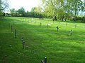
Military cemetery on Dürrerhofer Weg

Hötzelsroda settlement aerial photo


Web links
- www.eisenach.de - Official website of the Wartburg city Eisenach
Individual evidence
- ↑ Official topographic maps of Thuringia 1: 10,000. Wartburgkreis, district of Gotha, district-free city of Eisenach . In: Thuringian Land Survey Office (Hrsg.): CD-ROM series Top10 . CD 2. Erfurt 1999.
- ↑ Manfred Stimming, Peter Acht, Mainzer Urkundenbuch. Vol. II. Part 1 No. 38.Darmstadt 1968.
- ↑ a b c N.N .: Local research in Hötzelsroda . In: Eisenacher Zeitung (EZ) . No. 236 of October 8, 1927. Eisenach 1927.
- ↑ The castle buildings were still there in the 1920s, and they were demolished shortly after the Second World War.
- ^ Karl Heinz Dietze: 1804, the last pyre was worth it in the Eisenach district . In: MFB-Verlagsgesellschaft (ed.): StadtZeit . July issue. Frisch, Eisenach 1995, p. 24 .
- ^ C. Kronfeld, Regional Studies of the Grand Duchy of Saxony-Weimar-Eisenach. Second part. Weimar 1879.
- ↑ "Eisenach district celebrates 75 years of the Hötzelsroda settlement" accessed on www.eisenach-online.de on August 13, 2012
- ^ Thuringian State Office for Statistics , accessed on September 26, 2014
Districts: Berteroda | Eisenach | Göringen | Hörschel | Hötzelsroda | Madelungen | Neuenhof | Neukirchen | City field | Stockhausen | Stregda | Waiting
Settlements belonging to the core town of Eisenach: Fischbach | Realms | Hofferbertaue | High sun | Ramsborn | Rothenhof | Südviertel | Trenkelhof
Belonging to Hötzelsroda: Dürrerhof | Land dispute | Middle courtyard
Belonging to Stedtfeld: Rangenhof