
Stockhausen (Eisenach)
|
Stockhausen
City of Eisenach
Coordinates: 50 ° 59 ′ 26 ″ N , 10 ° 22 ′ 59 ″ E
|
|
|---|---|
| Height : | 230 m |
| Area : | 3.95 km² |
| Residents : | 687 (2018) |
| Population density : | 174 inhabitants / km² |
| Incorporation : | July 1, 1994 |
| Postal code : | 99817 |
| Primaries : | 03691, 036920 |
 Location of Stockhausen in Eisenach
|
|
 View from Leimenberg to Stockhausen
|
|
Stockhausen is a district of Eisenach in Thuringia .
geography
Stockhausen is located northwest of the Hörselberge in the natural area of Werrabergland-Hörselberge , which includes the areas of the northern Eisenach urban area dominated by limestone slabs. The place is in the lower Nessetal , about five kilometers northeast of Eisenach. At the western edge of the village the Holzbach flows into the Nesse. The highest point is the Leimenberg 315.2 m above sea level. NN south of the locality. The geographic height of the place is 230 m above sea level. NN .
The neighboring towns of Stockhausen are the city of Eisenach in the south, the district of Hötzelsroda in the west , the districts of Beuernfeld and Großenlupnitz of the municipality of Hörselberg-Hainich in the north and east and the municipality of Wutha-Farnroda in the southeast .
history
Archaeological finds in the "Feuersteinland" and on the high bank of the Nesse refer to the first settlements in the Stockhausen district since the Neolithic Age . The earliest document on local history is a document from 1043. It documents a place called "Stochus" in a letter from King Heinrich III. When interpreting the place name, one refers to the field names "Stockholz", "Stockstück" and "am Stockraine", which are still known around the place. The derivation "stoc" = root stock, trunk suggests a cleared settlement in the still wooded area west of the Hörselberge.
The location is laid out in the form of a street village. The church is in an exposed position on the western edge of the village. In the Nesseaue in front of the village there is a watercress pond as a relic of medieval cultivation . In the Middle Ages there was a small settlement to the west of the town and the Meierhof Metschrieden , from which the later Gut Dürrnhof emerged. The early days of the place were closely linked to the neighboring community of Großenlupnitz. In the village of Lupnitz there was already a royal estate in Carolingian times, which was administered by the Hersfeld monastery . At the same time, the original parish of the lower Nessetal was located in Lupnitz with the Peterskirche .
According to Schulze and other sources, the main camp of the Hungarian invasions in 908 was said to have existed for a few weeks in the Nessetal or on the Petersberg near Eisenach, and the then Thuringian Margrave Burchard is said to have died as leader of a Franconian-Thuringian army in these battles.
During the Saxon uprising 1074-1076, King Heinrich IV's troops devastated the villages of the Nessetal and southern Hainich. The unpaved Stockhausen could also have been destroyed during these fighting (in Bruno's book of the Saxon War “De bello Saxonico” - written down in 1080).
After 1250 "Lords of Stockhausen" are mentioned. They are said to have built the Malittenburg near Eisenach. This castle was destroyed as early as 1261 and the knights were driven out. Parts of Stockhausen are temporarily owned by the Hellgreve family from Eisenach and the Counts of Henneberg . The place now belongs to the Wartburg office ; the lords of Herda and von Uetterodt exercised the lower jurisdictions until 1850 . The interests of the respective gentlemen were represented in Stockhausen by two mayors who governed both halves of the town independently of one another. As in many other villages around Eisenach, residents of Stockhausen also took part in the Peasants' War in 1525. The rebellious residents of the village had to pay a fine of 30 guilders for this. After the Henneberg counts died out, the place passed to the Duchy of Saxony-Gotha in 1670 . Duke Ernst I, the Pious , had the Stockhausen Church built on a small hill above Dorfstrasse in 1671. The town's fire department was first mentioned in 1813 . In 1814 the Stockhausen Brewery was established, which was closed again in the middle of the century when the brewery in Eisenach was established. In 1844 the Eisenach textile manufacturer family Eichel acquired the neighboring Dürrerhof manor . The statistical information given by Kronfeld in 1878 shows that Stockhausen has 44 houses and 258 inhabitants. The Stockhausen district is 397 hectares; from 1872 to 1882 the separation took place.
Since 1910 a small power station on the Nesse has been supplying households with electricity. From 1922 Stockhausen became a district of Eisenach, which was reversed in 1924 by a government resolution. Not far from the Dürrerhof aircraft engine plant, a training building was built in the 1940s and used as a pilot school. Because of these strategic goals and the nearby motorway , the Stockhausen area was bombed several times during World War II.
On the night of April 2, 1945, the town's mayor, Karl Haupt, left the town. On the night of April 3, the Wehrmacht sent a 60-man commando to defend the town against the approaching US Army ; the raising of a white flag by the citizens of Stockhausen was prevented under threat of execution. After a short battle and shelling of the place, it was occupied by the US Army three days before the nearby town of Eisenach was occupied. Military personnel from both sides and a civilian were killed in the fighting and several buildings were damaged. On July 1, 1945, the Americans withdrew from Stockhausen; the place became part of the Soviet occupation zone and later the GDR.
In 1954 the first LPG of type III was founded. From April 1960 Stockhausen was a fully cooperative village ; the LPG "unit" was formed in 1966. Stockhausen was designated by the state- planned economy of the GDR as the location of a dairy cattle facility, which was built in 1972 against the will of the population.
On November 20, 1992, 78 percent of the residents of Stockhausen decided to be incorporated into Eisenach. With the administrative reform of July 1, 1994, Stockhausen and other places were incorporated into Eisenach.
Attractions
- Stockhausen village church
- Memorial stone for those who fell in the world wars
- Watercress pond

The village church

Memorial to the dead of the world wars
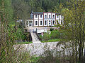
Power station

Watercress pond


economy
Established businesses
- Truck-Lite Europe
- ATEGE Logistik GmbH
- Kausch Batterieservice GmbH
- Lioptec fiber optics and lighting technology GmbH
- Umweltservice Wartburgkreis GmbH
- Recro waste management GmbH
- Diakonie-Verbund Eisenach
traffic
The town is crossed by the federal highway 84 and the district road 2a, which opens up the industrial area that has existed since 1992. The closest connection to the federal motorway 4 is the Eisenach-Ost junction near Großenlupnitz. The closest railway connection is at Eisenach station . The Eisenach-Kindel airfield in the Wenigenlupnitz district serves regional air traffic .
Web links
- www.eisenach.de - Official website of the Wartburg city Eisenach
Individual evidence
- ↑ Official topographic maps of Thuringia 1: 10,000. Wartburgkreis, district of Gotha, district-free city of Eisenach . In: Thuringian Land Survey Office (Hrsg.): CD-ROM series Top10 . CD 2. Erfurt 1999.
- ↑ Bernd Stichling: On the past and present of the village of Stockhausen . In: Eisenach-Jahrbuch 1993. Marburg 1993. pp. 126–128.
- ^ Adolf Moritz Schulze : Heimathskunde for the residents of the Duchy of Gotha . Volume II. Gotha 1846. p. 10.
- ^ Gerhard Kühn: The parishes of the Eisenach church district and their churches . Berlin 1989. p. 69.
- ^ C. Kronfeld: Regional studies of the Grand Duchy of Saxony-Weimar-Eisenach . Second part. Weimar 1879. p. 54.
- ^ Birgit Schellbach: Stock houses wanted to hoist the white flag; Thuringian General / Eisenacher General from 2./3. April 2015
Districts: Berteroda | Eisenach | Göringen | Hörschel | Hötzelsroda | Madelungen | Neuenhof | Neukirchen | City field | Stockhausen | Stregda | Waiting
Settlements belonging to the core town of Eisenach: Fischbach | Realms | Hofferbertaue | High sun | Ramsborn | Rothenhof | Südviertel | Trenkelhof
Belonging to Hötzelsroda: Dürrerhof | Land dispute | Middle courtyard
Belonging to Stedtfeld: Rangenhof