Ramsborn
|
Ramsborn
City of Eisenach
Coordinates: 50 ° 59 ′ 45 ″ N , 10 ° 17 ′ 6 ″ E
|
||
|---|---|---|
| Height : | 300 m above sea level NN | |
| Postal code : | 99817 | |
| Area code : | 03691 | |
|
Location of Ramsborn in Thuringia |
||
|
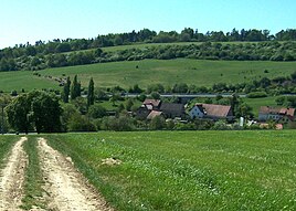
The district of Ramsborn from the north
|
||
The Ramsborn is a western part of the Wartburg city Eisenach in Thuringia .
location
The district of Ramsborn is located on the western edge of the core town of Eisenach, immediately to the northwest of the Karlskuppe residential area . For a long time, Ramsborn was located between Bundesstraße 7 - Kasseler Straße and Bundesautobahn 4 , which is now a section of Bundesstraße 19 in this section with the re-routing in the Eisenach area . The geographic height of the place is 280 m above sea level. NN .
Place name
The name Ramsborn refers to the Ramsborn spring, which has been documented here for centuries and which in turn is derived by name from Ramsberg, which was first documented in 1397 .
history
The extensive land area west of the medieval city of Eisenach belonged to the village of Stedtfeld , which was divided into the districts of Oberstedtfeld (on the Michelskuppe) and Niederstedtfeld. About one kilometer northwest of Oberstedtfeld, the settlement of Rammsleybin was founded in a small side valley before 1200 . Close to the town of Ramsborn, the Creuzburger Strasse leading across the Mosewald moved as a section of the Altstrasse Lange Hessen into the Werra Valley. The settlers in Ramsborn had to provide pre-tensioning assistance for the commercial wagons that passed here.
After the Thirty Years' War the village was deserted and was rebuilt as a chamber property. The incorporation into the city of Eisenach took place in 1922. At that time only the estate existed with its commercial and residential buildings.
It was not until 1960 that the first new farmers and workers from the city of Eisenach began to settle on a dirt road above the estate, and the expansion of the settlement intensified again in the 1990s. There are now around 15 residential buildings on Ramsborn. The supply takes place via the nearby Karlskuppe housing estate .
Others
To the south of the village, on the eastern slope of the Ramsberg, is the Marktbörner Feld . From there, since the late Middle Ages, water has been diverted into the town of Eisenach in wooden gutters and the Eisenach market fountain has also been fed. The very rich spring is used today by the waterworks on the Karlskuppe .
Web links
Individual evidence
- ↑ Official topographic maps of Thuringia 1: 10,000. Wartburgkreis, district of Gotha, district-free city of Eisenach . In: Thuringian Land Survey Office (Hrsg.): CD-ROM series Top10 . CD 2. Erfurt 1999.
- ↑ Gerd Bergmann: Michelskuppe and Gaisköpf . In: MFB Verlagsgesellschaft mbH Eisenach (ed.): StadtZeit. City journal with information from the Wartburg district . May issue. Druck- und Verlagshaus Frisch, Eisenach 1999, p. 39-40 .
- ↑ http://www.eisenachonline.de/geschichte-von-eisenach/1900-1945 accessed on March 19, 2011
- ^ Gerd Bergmann: Older history of Eisenach. From the beginning to the beginning of the 19th century . Ed .: Eisenacher History Association. Kröner, Eisenach 1994, ISBN 3-9803976-0-2 , p. 322 .

