
Hörschel
|
Hörschel
City of Eisenach
Coordinates: 51 ° 0 ′ 29 ″ N , 10 ° 13 ′ 44 ″ E
|
|
|---|---|
| Height : | 201 m |
| Area : | 1.86 km² |
| Residents : | 245 (2008) |
| Population density : | 132 inhabitants / km² |
| Incorporation : | April 1, 1974 |
| Incorporated into: | Neuenhof |
| Postal code : | 99817 |
| Area code : | 036928 |
 Location of Hörschel in Eisenach
|
|

Hörschel is a district of the independent city of Eisenach at the confluence of the Hörsel in the Werra in Thuringia . Hörschel is known nationwide as the start of the Rennsteig .
geography
Hörschel is located about six kilometers (as the crow flies) west of Eisenach on the right bank of the Werra , in the central Werra Valley, on the western edge of the Thuringian Forest . The place is in the Thuringian Forest Nature Park . In the village, the Hörsel flows into the Werra. This is where the Rennsteig begins , a 169.3 km long hiking trail that leads over the ridge of the Thuringian Forest and the Thuringian Slate Mountains to the foothills of the Franconian Forest in Blankenstein an der Saale . Following an old tradition, hikers in Hörschel take a stone from the Werra at the beginning of the Rennsteig, which they carry over the entire Rennsteig to sink it into Blankenstein in the Saale or the Selbitz .
Hörschel borders the Eisenach districts of Wartha in the west, Neuenhof in the south, Stedtfeld in the east and the districts of Pferdsdorf and Spichra of the municipality of Krauthausen ( Wartburgkreis ) in the north. The geographic height of the place is 201 m above sea level. NN .
The basalt dike at Hörschel station is a geological fault zone and a geotope designated as a natural monument .
history
Finds at the foot of the Hörschelberg, such as tools from the Neolithic Age or pottery shards from the Iron Age, prove that people settled here a long time ago. The first written mention of Hörschel happened on June 1, 932, when it was exchanged from Heinrich I to the abbot of Hersfeld , Megingoz, as hursilagemundi . For a long time the small village remained in the possession of three lords: the rulers of Wartburg , the lords of Boyneburg and the Hersfeld abbey , later the Treusch von Buttlar family was named instead of the Hersfeld abbey . As a result, Hörschel belonged to three, later to two courts until 1850: the Eisenach Justice Office, the Stedtfeld Court (both in the Eisenach Office ) and the Spichra Court (in the Creuzburg Office ).
Even in 1532, when the Benedictine monk Curt Hauser (his tombstone is in the Hörschel church ) planted a linden tree in front of the old village church in memory of the Augsburg confession , which had stood on the village square for four centuries, taxes still had to be paid to these gentlemen. The town was divided into three parts until 1843: 128 people lived in the 22 houses of the village at that time.
Since 1830 Hörschel had become the destination of all hikers who wanted to follow in Julius von Plänckner's footsteps on the Rennsteig. On June 25, 1847, the Thuringian Railway near Hörschel was completed, where the place received its own train station in 1892. 1862 damaged flood of the century the Hörsel the village, the mill dam was destroyed here.
When the Rennsteig Association was founded in 1896 , the village, on the banks of which the Rennsteig begins, became better known. The village flourished and grew - the Hörschler were wealthy enough to be able to build a new church in 1904/05.
In 1921 a hydroelectric power station was built at the weir on the Hörsel, which from then on supplied Hörschel and Neuenhof with electricity.
On March 31, 1945 Hörschel was evacuated because of the US Army advancing in World War II . Large parts of the village were destroyed by artillery fire on April 1, 1945. One of the first grenades shot off the top of the church tower. Above all, the town center with the church went up in the flames, 18 residential buildings were destroyed and others damaged. Retreating German soldiers blew up the Hörsel Bridge. The Boyneburgk memorial on the Hörschelberg, a memorial for a veteran of the Napoleonic Wars , was also destroyed. On April 4, US forces entered the town.
1952 - with the establishment of the restricted area on the inner-German border - Hörschel's time as a tourist destination came to an end. Only a few visitors were allowed to enter the village - provided they had the appropriate official permits. Anyone wishing to hike the entire length of the Rennsteig began their hike in Eisenach, and Hörschel also did not mention the maps as the start of the Rennsteig. The linden tree planted by Curt Hauser in front of the church had to give way to the expansion of the country road in 1959.
In 1974 Hörschel formed a community association with Neuenhof; Since 1994, both places have belonged to the city of Eisenach as a district.
Thanks to the village renewal program and funding from the State of Thuringia, the village square was redesigned after 1990, a restaurant and a guesthouse (“Tor zum Rennsteig”) as well as the tourist information in the Rennsteig hiking house are available. The church has also been extensively renovated and restored both inside and out since 1995. On November 26, 2004, the church tower could be put back in its original shape. On December 15, 2007, the crowning of the tower in its historical version found its place on the top of the tower: Decorated with a tower ball (tower button), cross and weathercock , the tower is complete again.
traffic
Hörschel can be reached via the state road L 1021 ( Eisenach - Gerstungen ). The road touches the town in the north, at the eastern portal of the Hörschel road tunnel , the K 505 district road branches off to Lauchröden via the Hörschel and Neuenhof locations. There is also a connection to Spichra to the district road K 19. Beyond the Werra bridge, the state road L 1021 joins the L 1017 (formerly federal road 7a ), so that the neighboring towns of Herleshausen and Pferdsdorf can be reached. The nearest junction ( Herleshausen ) of the A4 is in Herleshausen, three kilometers away.
Hörschel has a DB stop on the Thuringian Railway . Wartburgmobil bus stops are approached in Hörschel and Neuenhof.
politics
The district has a common district constitution with the neighboring village of Neuenhof . In the election on May 25, 2014 , Gisela Büchner was re-elected as mayor of both towns.
Attractions
- Rennsteig start
- Geological outcrop at the train station
- restored Hörschel Church
- Motorway bridge over the Werra
Impressions

Omnipresent in town - the Werra Valley Bridge

Basalt passage at Hörschel station

The Rennsteighaus

Half-timbered house at the church
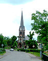
The church, with a new dome since 2008


Web links
Individual evidence
- ↑ Official topographic maps of Thuringia 1: 10,000. Wartburgkreis, district of Gotha, district-free city of Eisenach . In: Thuringian Land Survey Office (Hrsg.): CD-ROM series Top10 . CD 2. Erfurt 1999.
- ^ Geyer, Jahne, Storch: Geological sights of the Wartburg district and the independent city of Eisenach . In: District Office Wartburgkreis, Lower Nature Conservation Authority (Hrsg.): Nature conservation in the Wartburgkreis . Booklet 8. Druck- und Verlagshaus Frisch, Eisenach and Bad Salzungen 1999, ISBN 3-9806811-1-4 , The Werra breakthrough at Hörschel and the basalt passage at Hörschel station, p. 56-57 .
- ↑ a b Chronicle of Neuenhof ( Memento of the original dated June 2, 2015 in the Internet Archive ) Info: The archive link was inserted automatically and has not yet been checked. Please check the original and archive link according to the instructions and then remove this notice. , accessed June 25, 2014
- ↑ Hörschel commemorates the end of the war 60 years ago , eisenach-online.de, accessed on June 26, 2014
- ↑ 100 years of Hörschel Church , eisenach-online.de, accessed on June 26, 2014
- ↑ § 3 Paragraph 1 of the main statute of the city of Eisenach from March 4, 1997 (PDF; 93 kB)
- ^ Thuringian State Office for Statistics , accessed on May 26, 2014
Districts: Berteroda | Eisenach | Göringen | Hörschel | Hötzelsroda | Madelungen | Neuenhof | Neukirchen | City field | Stockhausen | Stregda | Waiting
Settlements belonging to the core town of Eisenach: Fischbach | Realms | Hofferbertaue | High sun | Ramsborn | Rothenhof | Südviertel | Trenkelhof
Belonging to Hötzelsroda: Dürrerhof | Land dispute | Middle courtyard
Belonging to Stedtfeld: Rangenhof