Spichra
|
Spichra
Community Krauthausen
Coordinates: 51 ° 1 ′ 19 ″ N , 10 ° 14 ′ 15 ″ E
|
|
|---|---|
| Height : | 196 m above sea level NN |
| Residents : | 186 |
| Incorporation : | January 1, 1957 |
| Incorporated into: | Horse village-Spichra |
| Postal code : | 99819 |
| Area code : | 036926 |
|
Location of Spichra in Krauthausen
|
|
|
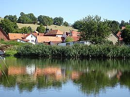
View over the Werra to Spichra
|
|
Spichra is an agricultural district of the municipality of Krauthausen in the Wartburg district in West Thuringia . The district is about three kilometers west of Krauthausen as the crow flies on the east bank of the Werra .
geography
The district borders the town of Creuzburg in the north, the districts Krauthausen and Deubachshof in the east, the Eisenach district of Hörschel in the south and Pferdsdorf (Krauthausen) in the west . The Lange Graben, an orographically right tributary of the Werra, flows through the village from Deubachshof . The geographic height of the place is 186 m above sea level. NN .
history
As part of the Creuzburg district , the place belonged to various Ernestine duchies , most recently from 1662 to Saxony-Eisenach and from 1741 to Saxony-Weimar-Eisenach . In 1920 he came to the state of Thuringia .
During defensive battles on April 1, 1945, most of the buildings in Spichra were hit by American fire and burned down. The bridge at the power station was blown up, the local farmers and their stocks evacuated in good time. Wehrmacht units put up considerable resistance in the Spichra-Hörschel area and inflicted heavy losses on the US armored forces. Their crossing over the Werra was prevented here. Thereupon they turned to the north, towards the still intact Werra bridge from Creuzburg there . In 1946 the reconstruction of the place began.
From 1949 to 1990, the development of the place was shaped by its location in the restricted area of the inner German border . In 1974, Pferdsdorf was combined with Spichra to form the parish of Pferdsdorf-Spichra. In March 1994 the previously independent community of Pferdsdorf-Spichra was incorporated into Krauthausen.
traffic
The federal highway 4 runs south of the district with the Hörschel bridge over the Werra valley . There is a connection to this at the junction '' Eisenach-West '' near Deubachshof and in Herleshausen. A district road connects Spichra with the state road 1017 , which until 2009 was dedicated as federal road 7a and runs through the district in the direction of Eisenach and Herleshausen.
The Werra Valley cycle path connects Spichra to the south with Hörschel and to the north with the Wilhelmsglücksbrunn monastery and the city of Creuzburg. Spichra is connected to Pferdsdorf by a local road.
Attractions
church
The Holy Trinity Church is located in the center of Spichra ; the church in its present form was built in 1753 after renovations from a chapel built in 1626. Inside the church there is a baptismal font dating from the 17th century with the family coat of arms of the patron saints of Buttlar and von Herda . There is a sundial on the south facade. The Spichra church was also badly damaged in the fighting on April 1, 1945 and could only be fully used again by the parish in 1958.
Hydroelectric power plant
The technical monument, built between 1923 and 1925, was first put into operation on October 24, 1925. After the corrosive fracture of a weir roller, the power plant was shut down in 1984. TEAG Thüringer Energie AG reconstructed the structure in 1997 for 5.9 million Deutschmarks. In February 1998 the system went back on line and is now operated by Thüringer Energie AG . Since then, three Francis shaft turbines have been working with a maximum output of 1300 kW. In 2009 a fish lock was installed to meet the requirements of the EU Water Framework Directive . In 2011, the pedestrian bridge across the Werra belonging to the power plant was rebuilt in accordance with the listed building standards.
Web links
- The Spichra case in 1945 , contemporary witness report at the end of the war in Spichra
Individual evidence
- ↑ Official topographic maps of Thuringia 1: 10,000. Wartburgkreis, district of Gotha, district-free city of Eisenach . In: Thuringian Land Survey Office (Hrsg.): CD-ROM series Top10 . CD 2. Erfurt 1999.
- ^ Rainer Lämmerhirt: The fight for the Werra line in April 1945 . Rockstuhl Verlag, Bad Langensalza 2005. ISBN 3-937135-64-2 . Pp. 68-69
- ↑ The Spichras case 1945 , hainichland.de, accessed on November 11, 2019
- ^ Thuringian ordinance on the dissolution and amalgamation of the communities of Krauthausen, Pferdsdorf-Spichra and Ütteroda of March 25, 1994 (GVBl p. 391)
- ^ Gerhard Kühn: Churches in Eisenacher Land . Evangelische Verlagsanstalt, Berlin 1989, p. 112 .
- ↑ Information board at the power plant


