Lengroden
|
Lengroden
Community Krauthausen
Coordinates: 51 ° 1 ′ 34 ″ N , 10 ° 15 ′ 32 ″ E
|
|
|---|---|
| Height : | 217.7 m above sea level NN |
| Postal code : | 99819 |
| Area code : | 036926 |
|
Location of Lengröden in the municipality of Krauthausen
|
|
|
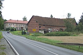
The former Lengröden manor
|
|
Lengröden is a district of Krauthausen in the Wartburg district in Thuringia .
location
Lengröden is about one kilometer northwest of Krauthausen and 10 km from Eisenach in a depression, directly on the federal highway 7 in the Eisenach- Creuzburg section . The Madel , a second order body of water, flows through the settlement . The geographic height of the place is 218 m above sea level. NN .
history
Lengröden was first mentioned in a document in 1461. The former manor was owned by the von Buttlar family , among others , whose family coat of arms can still be seen on a stone in the main building. For centuries, however, Lengröden belonged to the von Nesselröden , temporarily also from Uslar (today: Uslar-Gleichen ) and from the 17th to the 18th century half of the "Burgraves of Kirchberg". Lengröden's story was always closely linked to Krauthausen. The place belonged like this to the office of Creuzburg in the Duchy of Saxony-Eisenach or Saxony-Weimar-Eisenach .
During and after the Second World War , Gut Lengröden initially belonged to the property of the city of Eisenach; the city administration headed by Karl Hermann used it to accommodate refugees and displaced persons. At the same time, the previous owner was expropriated for political reasons. In the turmoil of the post-war period, the property was repeatedly the target of acts of sabotage, and the barn building on the street was also destroyed by flames and cattle theft.
In the mid-1950s, as part of the collectivization of agriculture in the GDR , the property that had remained undamaged in the Second World War was assigned to a Creuzburg LPG and run down by it. The dilapidated buildings of the manor now house apartments and an antique shop .
Opposite the manor was the Untermühle in the 1960s; today there are two houses there on the Madel. The natural stone bridge formerly located on the Madel was demolished around 1985 when the federal highway 7 was straightened and expanded. The bridge, made of yellow sandstone, was probably built by the master builder Gottfried Heinrich Krohne , as he often worked on ducal orders in Creuzburg from 1741 to 1748 and also had to renovate the damaged Werra bridge with the Liborius chapel there.
The old trees to the east of the main building are reminiscent of the park located here. About 500 m east of the estate, on the edge of the Lengröder wood above the Molkengraben, was the Buttlar hereditary burial of the landlords, of which only sparse remains can be seen today.
Sons and daughters of the place
- Wilhelm Treusch von Buttlar-Brandenfels († 1889), Prussian major general
Web links
Individual evidence
- ↑ Official topographic maps of Thuringia 1: 10,000. Wartburgkreis, district of Gotha, district-free city of Eisenach . In: Thuringian Land Survey Office (Hrsg.): CD-ROM series Top10 . CD 2. Erfurt 1999.
- ^ Wolfgang Kahl: First mention of Thuringian towns and villages. A manual. Rockstuhl Verlag, Bad Langensalza, 2010, ISBN 978-3-86777-202-0 , p. 162
- ↑ Petra Dietzel: Festschrift for the 300th anniversary of the church in Krauthausen 1709-2009. Krauthausen parish, 2009
- ^ Günter Wenzel: Eisenach 1945-1952 . In: Eisenach writings on local history . Issue 42. Eisenach 1989, p. 70, Appendix 4 .
- ↑ Creuzburg fire brigade chronicle
- ↑ Information on the district ( Memento of the original from July 16, 2011 in the Internet Archive ) Info: The archive link was inserted automatically and not yet checked. Please check the original and archive link according to the instructions and then remove this notice. on the homepage of the Verwaltungsgemeinschaft Creuzburg ; Retrieved March 29, 2012

