
Stregda
|
Stregda
City of Eisenach
Coordinates: 51 ° 0 ′ 7 ″ N , 10 ° 18 ′ 54 ″ E
|
|
|---|---|
| Height : | 257 m |
| Area : | 6.94 km² |
| Residents : | 1425 (2018) |
| Population density : | 205 inhabitants / km² |
| Incorporation : | December 10, 1991 |
| Incorporated into: | Lerchenberg |
| Postal code : | 99817 |
| Area code : | 03691 |
 Location of Stregda in Eisenach
|
|
 The church
|
|
Stregda is a district of Eisenach in Thuringia .
geography
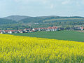
Stregda is located immediately north of Eisenach on the northern edge of the Eisenacher Valley. The Michelsbach , a right tributary of the Hörsel, flows through the village . A former lake on the outskirts has silted up and is used as a meadow. The highest elevations in the district are the Moseberg (364 m) in the west, the Läuseberg (324 m) in the north and the Wartenberg (303 m) in the east. The neighboring towns of Stregda are the city of Eisenach in the south and its districts of Hötzelsroda in the east, Neukirchen and Madelungen in the north and northwest and the community of Krauthausen ( Wartburgkreis ) in the west .
history
During the mining of the clay deposits in the 1870s, extensive remains of a ceramic band settlement on Michelsbach were discovered and systematically excavated and examined by the then owner of the brickworks , Johann Georg Bornemann . According to today's archaeological chronology, the majority of the finds have since been assigned to the late La Tène culture , LT D 2. It is one of the oldest verifiable predecessor settlements in the Eisenach urban area.
The earliest written mention of the place name was in a document dated August 23, 1287. In this document, Landgrave Albrecht the Degenerate gives his people in "Stregede" lower jurisdiction and allows them to be exempt from customs duties on the landgrave's markets. In the Middle Ages, the history of the place was closely interwoven with that of the neighboring town of Eisenach, although the place belonged to the Creuzburg office . The earliest owner of the village to date is a knight Gotzo von Remstedte , who sold his possessions in the village to the Nikolaikloster von Eisenach in 1324. In the 13th century the construction of the Stregda church began. It was the oldest stone building in town and became a branch of the Neukirchen church of St. Ulrich. The Nikolaikloster maintained a farm yard in the village. According to local tradition, the nuns' laundry was washed at Schleiersborn . There is no evidence of a castle site in the Mosewald near the village, which has also been handed down, the designated site and a paved access road in the forest were identified as remnants of medieval sandstone quarries. Numerous buildings in the Old Town Eisenacher were built with proven building material from the Mosewaldbrüchen, the Stregdaer were as forced labor in charge of the paving of the Eisenacher squares and alleys.
In a major fire on June 25, 1872, 24 houses were destroyed by flames. At that time, the place had 65 houses and 350 residents. For preventive fire protection , the slate or plastering of the half-timbered house facades was promoted. The fire road was also laid out, which is intended to interrupt the long row of houses along the main road.
The church in Stregda was damaged and robbed several times during fighting and looting, for example by the Swedes in 1632, by Croatians in 1637 and by Bavarian troops in 1640. The structural enlargement of the nave that took place in 1817 became unstable and therefore, with the permission of the Grand Duke, the church had to be dismantled down to the foundations and rebuilt in 1906. The inauguration took place on December 9, 1906.
On the basis of significant clay deposits, the most modern brickworks were built on the southern edge of the community after 1870, which were essential for the rapid development of Eisenach as a business location. At the same time, a mine train for material transport was laid out and operated until the 1970s. Even before the outbreak of the Second World War , work began in the eastern Mosewald and in the adjoining corridor to build bunkers and shooting ranges for the garrison in Eisenach . At the same time, the Reichsautobahn was planned and implemented in the Stregda section.
After the fall of the Wall , the brickworks were shut down. In 1991, Stregda became part of the Lerchenberg community , which was incorporated into Eisenach in 1994. During this time, an industrial park was built on the south-eastern edge of the municipality, a new connecting road to Hötzelsroda was built and a large residential area opened up in the north of Stregda. In 2004 and 2005, a flood retention basin was built on the Michelsbach flowing southeast of the village , which is intended to protect the northern core city of Eisenach from flooding. In the basin, 35 million liters of water can be dammed on an area of 2.83 hectares. With support from the Free State of Thuringia, around 380,000 euros were invested.
The Eisenach Arena leisure area was built on part of the former brickworks in 2005 , and from 2005 to 2010 it housed the MAD large-capacity disco, which is well-known across the region . In 2008 a bypass road was inaugurated, which has since relieved Stregda of through traffic. At the beginning of November 2011, the suicide of the two alleged right-wing terrorists Mundlos and Böhnhardt in Stregda attracted nationwide attention.
Culture and sights
- church
- Memorial stone for the fallen of the First World War
- Poststein and Töpfersborn in the Mosewald
The fair , always on the 2nd weekend in September, is particularly popular. At Whitsun, the Heimatverein organizes the Whitsun Festival on the nearby Whitsun pasture below the Mosewald.
- Impressions

Townscape, lower main street

Mühlhäuser Strasse
"Wartburgblick" new housing estate on Madelunger Straße
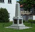
Fallen memorial at the church


Web links
Individual evidence
- ↑ Official topographic maps of Thuringia 1: 10,000. Wartburgkreis, district of Gotha, district-free city of Eisenach . In: Thuringian Land Survey Office (Hrsg.): CD-ROM series Top10 . CD 2. Erfurt 1999.
- ↑ Johann G. Bornemann About remains of the Stone Age in the vicinity of Eisenach , Korrbl. German Ges. Für Anthropologie, 1874, pp. 46–52
- ^ Geography of the Grand Duchy of Saxony-Weimar-Eisenach. Part 2, edited by C. Kronfeld, Weimar, 1879, p. 54
- ↑ Churches in the Wartburgland. Gerhard Kühn, Berlin 1989, p. 110
Districts: Berteroda | Eisenach | Göringen | Hörschel | Hötzelsroda | Madelungen | Neuenhof | Neukirchen | City field | Stockhausen | Stregda | Waiting
Settlements belonging to the core town of Eisenach: Fischbach | Realms | Hofferbertaue | High sun | Ramsborn | Rothenhof | Südviertel | Trenkelhof
Belonging to Hötzelsroda: Dürrerhof | Land dispute | Middle courtyard
Belonging to Stedtfeld: Rangenhof