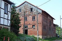
Fields (Eisenach)
The field is a small settlement in the east of the independent city of Eisenach in Thuringia .
location
Gut Gefilde is located 700 meters east of the city park on the eastern slope of the Göpelskuppe within sight of the fraternity monument . The geographic height of the place is 283 m above sea level. NN . The area can be reached from the Fischbach district to the north or from the freight station through the Hängetal valley. In terms of planning law, the area is part of the core city of Eisenach.
history
Since the 13th century, a section of the Weinstrasse, coming from the Rennsteig on the Hohe Sonne , has led past today's area to the Nikolaitor in the old town of Eisenach. Hollow paths and field names are reminiscent of this early period. The agricultural areas of the medieval Eisenach were small in size and were based on a decree signed in 1283 by the Thuringian Landgrave Albrechts , therefore the enlargement of the town hall was a constant need of the councilors. The common land and the princely forest property at the gates of the city was managed for a fee by three hat cooperatives, which drove the city population's livestock to pasture. This division is said to have its origin in a contract with the Eisenach monasteries. The eastern boundary of the Hutebezirks "Claustörschen Hutegenosenschaft" went on today Mosbach belonging Kohlberg southeast of Roth court . Within the areas that were allowed to be grazed, “das Gefilde” was first mentioned as a field name in 1767 and, because of the spring located there, an important resting place for the shepherds. The town population of Eisenach, numbering around 11,000, had a herd of 500 cattle, 1,356 sheep, 1,524 pigs and 305 goats to farm in 1858, leather production and processing as well as sausage products were the most important in this time after textile production (Eichel-Steibersche worsted yarn spinning mills and textile factories) Economic base of the city. When the small "Frauentörsche Hutegenossenschaft" lost its traditional rights of use to the Marienthal and the adjacent heights and forests in legal proceedings around 1860, the other cooperatives also gave up.
Since 1837 at the latest, the Gefildehof has been an Eisenach excursion destination. In the valley close to the city, there was a shooting range laid out by an Eisenach rifle club since 1820. The rifle festivals, organized as a pastime, were originally a military necessity in order to train the city's defenders in the use of weapons, from 1818 the shooting range on the city wall was abandoned and distributed to various locations on the outskirts. The property was owned by Dr. Georg Bornemann, he let farm workers manage the property, a manager lived in the brick building on the access road, which is now demolished. From 1917 the area belonged, along with other areas on the eastern outskirts, to the Eisenach real estate company, which was dominated by his family. The Bornemann Bank at a popular view of the Wartburg not far from the field reminds of his wife.
After the expropriation of the property, the majority of the 11 houses in the area that exist today were laid out in the years 1948 to 1951 as a new farmer's settlement. The former estate has been used as a farm and horse farm with a guesthouse since 1993.
literature
- Günter Wenzel: Eisenach 1945–1952 . In: Eisenach writings on local history . Issue 42. Eisenach 1989.
- Herlind Reiss: City of Eisenach. Villas and country houses at the foot of the Wartburg . In: Thuringian State Office for Monument Preservation and Archeology (Ed.): Monument topography BRD. Cultural monuments in Thuringia . tape 2.1 . E. Reinhold-Verlag, Altenburg 2006, ISBN 978-3-937940-24-3 . (regarding the Bornemann family and plans of the Eisenach property company)
Individual evidence
- ↑ Official topographic maps of Thuringia 1: 10,000. Wartburgkreis, district of Gotha, district-free city of Eisenach . In: Thuringian Land Survey Office (Hrsg.): CD-ROM series Top10 . CD 2. Erfurt 1999.
- ^ Walter Fischer: Alteisenacher shepherd families . In: The Thuringian Flag . (Supplement) The Thuringian clan. Jena 1937, p. 41-47 .
- ↑ Website for the Gefildehof ( Memento of the original from August 21, 2014 in the Internet Archive ) Info: The archive link was automatically inserted and not yet checked. Please check the original and archive link according to the instructions and then remove this notice. accessed on August 16, 2012
Web links
Coordinates: 50 ° 57 ′ 45.7 ″ N , 10 ° 20 ′ 32.4 ″ E


