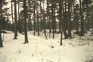
Malittenburg
| Malittenburg | ||
|---|---|---|
|
At the Malittenburg (1995) |
||
| Creation time : | around 1260 | |
| Castle type : | Höhenburg, spur location | |
| Conservation status: | Burgstall, arr. Rocks and cistern preserved | |
| Standing position : | Noble | |
| Place: | Eisenach | |
| Geographical location | 50 ° 58 '8.9 " N , 10 ° 21' 26.9" E | |
| Height: | 300 m above sea level NN | |
|
|
||
The Mali tablets Castle is an Outbound Spur castle and now a ground monument to 300 m above sea level. NN in the east of the city of Eisenach am Petersberg in the Fischbach district . The village of Fischbach, handed down as Vispach as early as 1269, belonged to the property of the Eisenach Nikolaikloster until the Reformation . The meaning of the name "Malittenburg" is still unclear.
history
In the Thuringian-Hessian War of Succession (1247–1263), a small fortification was built above the village on a mountain spur protruding into the Hörseltal valley . According to the Eisenach chronicler Johannes Rothe, this is said to have been initiated by a knight of Stockhausen from the neighboring village of Stockhausen or Lupnitz . The location had an extremely favorable strategic location in the lower valley of the Hörsel, the Spornburg monitored the traffic on the Erfurter Straße via regia and the nearby ford of the Weinstraße at the “Roten Hof”.
In 1261, Landgrave Heinrich the Illustrious began to conquer the siege castles of Metilstein , Eisenacher Burg and Frauenburg near Eisenach . On this occasion he also destroyed the Malittenburg.
Structural matters
The Malittenburg was a wooden spur castle, still clearly recognizable today, secured by ditches and ramparts. Eisenacher writer and journalist Hermann Nebe examined the castle in the 1920s, he describes the plant in a newspaper article: "... The trenches mentioned are 2 to 5 feet deep and but the south to the main castle (between the trenches lying Vorburg forms a trapezoidal of 8 × 30 × 35 meters) from an outer wall, which is difficult to see in some places. The main castle has the shape of a coat of arms, the two sides of which meet at right angles (north-west and south) ... is the perimeter of the inner castle about 150 meters, the entire castle about 180 meters. "
research
An inspection and survey carried out in the 1990s came to a different conclusion. The castle is therefore limited to the area that Nebe recognized as the "outer bailey"; the trenches in front of the main castle were created at a later time when several limestone quarries were being operated on the mountain. In the attached site plan, (1) corresponds to Malittenburg and (2) Schloss Fischbach ; (A) marks the plateau, (B) the outer wall-ditch fortification, (C) the inner ditch, (D) the core area of the castle, (E) a wall-ditch area on the west side of the complex; (a) More recent quarries and pits.
swell
- Hermann Nebe: The Malittenburg . In: The Wartburgland . Eisenach 1923.
- Helmut Scherf: Buildings and art monuments in the city and district of Eisenbach. Part II City of Eisenach. In: Kulturbund der DDR and Eisenach-Information (Hrsg.): Eisenacher Schriften zur Heimatkunde . Issue 15. Eisenach 1981, The Fischbacher Schlösschen, p. 67-70 .
- Gerd Bergmann: Malittenburg . In: StadtZeit . Issue 8. Printing and Publishing House Frisch, Eisenach 1994, p. 14-17 .
- Thomas Bienert: Medieval castles in Thuringia . Wartberg Verlag, Gudensberg-Gleichen 2000, ISBN 3-86134-631-1 , Eisenach, missing Malittenburg, p. 49 .
- Michael Köhler: Thuringian castles and fortified prehistoric and early historical living spaces . Jenzig-Verlag, Jena 2001, ISBN 3-910141-43-9 , Malittenburg, p. 180 .
- Eisenach and surroundings, Wartburg district, north . In: Sven Ostritz (Hrsg.): Archaeological hiking guide Thuringia . No. 11. Beier & Beran, Weimar 2007, ISBN 978-3-937517-67-4 , p. 102 .


