
Dürrerhof manor

The former men's or estate Dürrerhof, only a few foundations are obtained from the today was about three kilometers northeast of Eisenach , in the district Hötzelsroda , on the northwestern edge of today's parks Dürr Hofer located. A chestnut avenue that began at the upper Karolinental and led across the brick field connected the manor house with the city. The geographic height of the place is 305 m above sea level. NN .
history

The field name Dürrnhof is reminiscent, as an example of the same name from the village of Dürrnhof in the Franconian Haßberg region , of a fortified storage building believed to have been fortified here in the Middle Ages. The district of this settlement Dürrnhof originally belonged to the neighboring Stockhausen , a northeastern suburb of Eisenach in the Nessetal. In 1403 a place was named Meiczrit , whose inhabitants moved to the nearby town of Eisenach, as early as 1420 this place was described as desolate . After the Peasants' War , the Meierhof Metschrieden developed on the same site . The name Dürrerhof, also Dürrnhof or Doerrnhof, as part of the Metschrieden settlement, has been increasingly popular since the 18th century. The former Meierhof was converted into a representative mansion with a park. The Eisenach industrial family Eichel had achieved prosperity through their worsted spinning mill and cloth manufactories and acquired the country estates north of the city as a residence and business (sheep breeding). The Dürrerhof came into the possession of Carl Eichel, who had already taken over the neighboring properties in the middle yard and the Vorwerk Landstreit , later also an estate in Krauthausen . Around the Dürrerhof Eichel had a classic landscape park created by the garden architect Petzold, of which considerable remains can still be seen today.
Thanks to its exposed location, the Dürrerhof had direct visual links to numerous landmarks in the area - including the Petersberg , the Hörselberge , the Wartburg and the mountain scenery of the Thuringian Forest with the Inselsberg .
The facility remained untouched until the 1930s. In 1936, an area on the southern edge of the park was assigned for the construction of the BMW aircraft engine factory in Eisenach . This gained strategic importance as an armaments company and was repeatedly targeted by bombings. The remains of the work were almost completely removed after 1945. Since 2006, a memorial stone on the access road has been a reminder of the plant and the forced laborers employed there .
At the end of the Second World War at the beginning of April 1945, the Dürrerhof was a main first aid station for the Wehrmacht in the fight against the advancing US troops around the Werra line and the city of Eisenach. The Hötzelsroda war cemetery for more than 350 German soldiers was later laid out of the associated burial site, which was laid out in April 1945 with the bedding of other fallen soldiers . It is located 300 meters north of the settlement houses in the direction of Hötzelsroda.
After the Second World War, the last owners of the Dürrerhof mansion were expropriated, and the mansion, which had become very dilapidated after the end of the war, was classified as not worthy of preservation and demolished in 1947. The new farms that still exist today were built on the same spot . The park area was cut up at the edge by road construction and partially converted into arable land, the park was left to its own devices. The Hötzelsroda School has been looking after him since the 1970s , professionally supported by the preservation of garden monuments. In 1984 it became a monument of landscape and garden design and has been looked after by the city of Eisenach since 1992.
Structural matters
Since 1947 there have been no visible remains of the manor house built in the classical style. The former network of paths, a grotto and a memorial stone with eight virtues (FAITH, LOVE, HOPE, COURAGE, TRUTH, LOYALTY, DUTY and ORDER) have been preserved in the park. Two small ponds and hundreds of old deciduous trees enrich the place. On the north edge of the park, on the opposite side of the street, an almost 2 m high natural stone wall marks the area, which is probably used as a gardening and farmhouse, in which there are gardens today.
Impressions

Settlement house

Grotto in the listed landscape park

Kastanienallee at the Dürrerhof
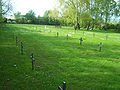
Dürrerhof military cemetery

Memorial stone at the entrance to the former aircraft engine plant


literature
- Bernd Mähler, Heinrich Weigel: Gardens, parks and park-like valleys and forest areas in the Eisenach district. Eisenach writings on local history. Issue 33. Eisenach 1985, pp. 71-76.
- Sheet Dürrerhof in: Album of the residences, castles and manors of Thuringia, in particular the Saxon lands of the Ernestine line. In pictorial representation. In connection with several accompanied by text u. published by Prof. Dr. J. Gersdorf, archivist in Altenburg, school director. Dr. AM Schulze in Gotha, Hofr. L. Bechstein in Meiningen, Prof. Dr. W. Rein in Eisenach, Dr. Ms. Hoffmann in Hildburghausen. I. issue. Leipzig, expedition. (Werl.) Qu. Fol. (First edition 1858).
- Constanze Werner: War economy and forced labor at BMW. Oldenbourg Verlag, Munich 2005, p. 447, ISBN 3-486-57792-1 .
- Frederic Gümmer: The role of underground relocation in German arms production 1943–1945. Grin Verlag, Hamburg 2008, p. 120, ISBN 3-638-92393-2 .
Individual evidence
- ↑ a b Official topographic maps of Thuringia 1: 10,000. Wartburgkreis, district of Gotha, district-free city of Eisenach . In: Thuringian Land Survey Office (Hrsg.): CD-ROM series Top10 . CD 2. Erfurt 1999.
- ↑ Eisenachonline: Memorial stone inaugurated at Dürrerhof. September 3, 2006, accessed November 27, 2008.
Web links
Districts: Berteroda | Eisenach | Göringen | Hörschel | Hötzelsroda | Madelungen | Neuenhof | Neukirchen | City field | Stockhausen | Stregda | Waiting
Settlements belonging to the core town of Eisenach: Fischbach | Realms | Hofferbertaue | High sun | Ramsborn | Rothenhof | Südviertel | Trenkelhof
Belonging to Hötzelsroda: Dürrerhof | Land dispute | Middle courtyard
Belonging to Stedtfeld: Rangenhof
Coordinates: 50 ° 59 '22.24 " N , 10 ° 21' 26.02" O