Bober
|
Bober Bóbr, Bobr |
||
|
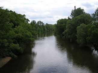
The Bober in Żagań |
||
| Data | ||
| location | Czech Republic , Poland | |
| River system | Or | |
| Drain over | Or → Baltic Sea | |
| source | Boberlehne near Bobr , Czech Republic 50 ° 40 ′ 51 ″ N , 15 ° 54 ′ 31 ″ E |
|
| Source height | 780 m | |
| muzzle | at Krosno Odrzańskie in the Oder coordinates: 52 ° 3 ′ 2 ″ N , 15 ° 4 ′ 18 ″ E 52 ° 3 ′ 2 ″ N , 15 ° 4 ′ 18 ″ E
|
|
| length | 268 km | |
| Catchment area | 5882 km² | |
| Left tributaries | Łomnica (Eng. Lomnitz), Kamienna (Zacken), Kamienica (Kemnitz), Kwisa (Queis), Czerna (Tschirne) | |
| Right tributaries | Zadrna (German cider), Lesk (casual), Szprotawa (sprat) | |
| Reservoirs flowed through | Bobertalsperre | |
| Medium-sized cities | Kamienna Góra , Jelenia Góra , Lwówek Śląski , Bolesławiec , Żagań , Nowogród Bobrzański | |
| Small towns | Lubawka , Wleń , Szprotawa | |
| Communities | Dychów (Ger.Deichow), Leszno Górne (Ober Leschen) | |
The Bober ( Polish Bóbr ; Czech Bobr ) is a left tributary of the Oder in southwestern Poland and northern Czech Republic .
course

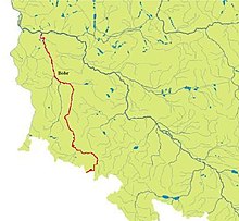
The Bober rises on Boberská stráň (Boberlehne) at Bobr (Bober) near Žacléř (Schatzlar) in the Czech part of the Rehorn Mountains , only a few hundred meters from the Polish border. It then flows through the place Bobr and on the Polish side roughly parallel to the Lusatian Neisse through Silesia to the north and crosses the cities of Jelenia Góra (Hirschberg in the Giant Mountains), Bolesławiec (Bunzlau), Szprotawa (Sprottau) and Żagań (Sagan). Finally it flows into the Oder at Krosno Odrzańskie (Crossen on the Oder) .
The Bober is not navigable along its entire length of 268 kilometers. It is very popular with canoeists . From Żagań downstream, the Bober forms the eastern border of Niederlausitz .
The river is dammed near Jelenia Góra with the Bobertalsperre , a gravity dam built from 1903. The structure is used for flood protection and the generation of electrical energy (6 Francis turbines , each 1 to 3 megawatts).
Oder-Bober Line
In the negotiations of the Allies about the future territory of Germany after the Second World War , the USA and Great Britain finally proposed the Oder-Bober Line (better: Oder-Bober- Queis Line) instead of the Oder-Neisse Line as the German eastern border which was also the eastern border of the Holy Roman Empire until the 14th century . The Soviet Union refused to give its consent.

Web links
- Hellmut Seidel: The tributaries of the Oder in Silesia: The Bober with the Queis. In: Arcor.de. March 2000, archived from the original on March 4, 2016 .

