Merkers Adventure Mine
| Marker | |||
|---|---|---|---|
| General information about the mine | |||
| Funding / year | 10.9 million t | ||
| Information about the mining company | |||
| Employees | 270 (today) | ||
| Start of operation | 1895 | ||
| End of operation | 1993 | ||
| Funded raw materials | |||
| Degradation of | Potash salt , rock salt | ||
| Greatest depth | 860 m | ||
| Geographical location | |||
| Coordinates | 50 ° 49 '13.3 " N , 10 ° 7' 29.3" E | ||
|
|||
| Location | Marker | ||
| local community | Krayenberg community | ||
| District ( NUTS3 ) | Wartburg district | ||
| country | Free State of Thuringia | ||
| Country | Germany | ||
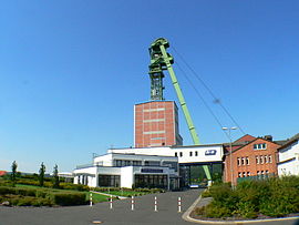
The Merkers Adventure Mine is a show mine in the Merkers district of the Krayenberg community in the Wartburg district in western Thuringia .
Geology and mining
The salt deposits of the Werra potash district were formed as deposits from the Zechstein Sea around 240 million years ago. Only layers of salt overlaid by impermeable layers have been preserved. The thickness of the salt layers varies between twenty and 150 meters. About the former salt mine belonging shafts Kaiseroda I ( drilled from 1895), II and III (both drilled from 1911). Potash salt was mined as a natural and efficient fertilizer, less table salt or de-icing salt . The mine has a route network of around 4600 kilometers and is now part of K + S Kali GmbH. The greatest depth is about 860 meters, there is a constant temperature of about 28 ° C.
Wintershall AG's Merkers plant began operations in 1925 as the world's largest potash factory. Like all plants in the potash industry in the Soviet occupation zone , the Merkers plant was expropriated in 1946 and initially transferred to Soviet ownership as the Soviet Stock Corporation (SAG) Kali . In 1952 the potash works were handed over to the GDR. In 1958 this resulted in the Association of Publicly Owned Enterprises Kali in Erfurt . In 1959 VEB Kalikombinat Werra was founded, which in 1970 became part of Kombinat Kali . In June 1990 the Treuhandanstalt founded Kali-Werra AG out of the combine and transformed the combine into Mitteldeutsche Kali AG . In 1993 Kali-Werra AG merged with Kali und Salz GmbH , which ceased mining in Merkers in the same year in favor of the Unterbreizbach plant (Thuringia). Securing work has been carried out in the shafts in the Merkers mine area since the end of production and the mine has served as an adventure mine since 1991 .
Adventure mine
During an approximately 21-kilometer round trip in a crew car, visitors learn details about the potash mining and can visit the storage location of the so-called Nazi gold , the crystal cave and a salt mining museum underground. In addition, the largest and deepest concert hall in the world, the so-called large bunker, is used. The tour through the mine takes about two to three hours, starting with a 90-second drive, at a maximum speed of about 8 meters per second, in a cage down to a depth of 500 meters. The Merkers Adventure Mine is the anchor point of the European Route of Industrial Culture .
Gold room
At the end of the Second World War in 1945, large parts of the Reichsbank's assets in the form of looted gold , cash in Reichsmarks and art treasures, including pictures from the Gemäldegalerie in Berlin and the bust of Nefertiti, were hidden in secure rooms of the mine and on April 8, 1945 by American people Troops discovered. The US Generals Omar N. Bradley and George S. Patton drove into the mine in April 1945 to examine the find, and a little later Dwight D. Eisenhower too .
Concert hall
At a depth of 500 meters , a former large bunker of the mine opens up with an extension of 250 meters in length, 22 meters in width and up to 17 meters in height. The bunker, in which 50,000 tons of raw salt could be temporarily stored and in which the largest underground bucket wheel excavator in the world is located, now serves as a concert hall with unusually good acoustics .
Crystal cave
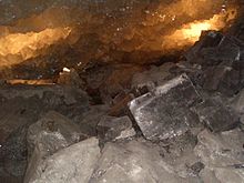
At a depth of 807 meters , next to a “crystal bar”, there is the crystal cave, discovered in 1980, with salt crystals with an edge length of up to one meter. This geological outcrop was placed under protection as a geotope .
Web links
- Website for the 700th anniversary of the town of Merkers with historical information
- Merkers Adventure Mine
- Crystal salt chimney in the Merkers Adventure Mine, description of the geotope by the Thuringian State Institute for Environment and Geology (TLUG)
Individual evidence
- ↑ 4,600 kilometers underground. (No longer available online.) Gießener Anzeiger , formerly in the original ; Retrieved February 3, 2011 . ( Page no longer available , search in web archives ) Info: The link was automatically marked as defective. Please check the link according to the instructions and then remove this notice.
- ^ Greg Bradsher: Nazi Gold. The Merkers Mine Treasure. Retrieved December 8, 2013 .
- ↑ Leaflet K + S Kali GmbH, without indication of the year of publication, distributed in 2008


