Oxen
| coat of arms | Germany map | |
|---|---|---|

|
Coordinates: 50 ° 45 ' N , 10 ° 4' E |
|
| Basic data | ||
| State : | Thuringia | |
| County : | Wartburg district | |
| Fulfilling municipality : | Dermbach | |
| Height : | 400 m above sea level NHN | |
| Area : | 12.53 km 2 | |
| Residents: | 597 (Dec. 31, 2019) | |
| Population density : | 48 inhabitants per km 2 | |
| Postal code : | 36404 | |
| Area code : | 036965 | |
| License plate : | WAK, SLZ | |
| Community key : | 16 0 63 062 | |
| Address of the municipal administration: |
Stadtlengsfelder Strasse 36404 Oechsen |
|
| Website : | ||
| Mayoress : | Brigitte Weinert (BI Oechsen) | |
| Location of the community of Oechsen in the Wartburg district | ||
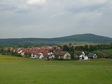
Oechsen is a municipality in the Wartburg district in Thuringia . The municipality of Dermbach is the fulfilling municipality for Oechsen .
geography
The municipality of Oechsen is located in the center of the Thuringian Rhön , about 15 kilometers (as the crow flies) west-southwest of the district town of Bad Salzungen in the valley of the Oechse . The highest point is the Schorn mountain ( 559.1 m above sea level ). The district of Lenders belongs to the municipality ; the core community of Oechsen has grown together with Niederoechsen . On June 30, 2009, 22 residents lived in the Lenders district.
history
The first historical mention took place in the year 977. The oldest forms of the name are: Uhsino, Uhseno, Ussine. The Oechsen settlement was owned by a Rasdorf monastery . In 1166 income from the Fulda monastery was recorded. Around the year 1214, Count Erpho von Neidhartshausen built a castle complex - the Schönburg - on the nearby Schorn mountain . According to tradition, Erpho is said to have illegally occupied the mountain, so he had to swear not to usurp any rights over the farmers of Oechsen. Today only small traces of the former castle can be seen.
The location and especially the St. Laurentius Church were provided with fortifications, the tower served as a defensive tower. The remains of the wall show that the church square was also protected by a sandstone wall (defensive wall). Parts of the church were demolished in 1586. In 1801 a new and larger church was built. As an exclave of the Vacha office , Oechsen came with it after secularization to the Landgraviate of Hessen-Kassel and in 1816 came to the Grand Duchy of Saxony-Weimar-Eisenach .
Potash salt deposits were developed in the Werra-Rhön area around 1890 . At Oechsen in Niederoechsen , too, work began on drilling two shafts. When the slab dolomite was poured into the ground, however, significant water inflows were encountered, which made further construction impossible.
politics
Municipal council
The municipality of Oechsen is made up of eight councilors.
- Citizens' initiative Oechsen: 8 seats
(As of: local election on May 26, 2019 )
mayor
The honorary mayor Ms. Brigitte Weinert was re-elected on June 6, 2010.
Culture and sights
Architectural monuments
The St. Laurentius Church was partially renewed in 1801.
Nature reserves and monuments
The Kalktuff-Niedermoor nature reserve is located about one kilometer west of the village in the direction of the neighboring village of Geblar and has a total area of 4.8 hectares; it was designated on September 11, 1967.
The more than three hundred year old village linden, the location of which served as a dance floor for centuries , was designated a natural monument in 1956 .
music Society
The Oechsen musicians play brass music and modern folk music.
Economy and Transport
Rail transport
With the expansion of the potash shafts, it became necessary to build a railway line from Oechsen to the Ulstertal Railway to Wenigentaft to transport the raw materials . The Wenigentaft-Oechsener Eisenbahn , which went into operation in 1912 , was used until 1952 both for the transport of basalt gravel from the open-cast mine on the Dietrichsberg and for passenger traffic.
Road traffic / public transport
Oechsen is on state road 1026 , which connects Geisa with Dermbach . Other state roads lead via Gehaus to Stadtlengsfeld and Vacha . The place is accessed by several bus lines operated by the Wartburgmobil transport company . There are bus connections to Bad Salzungen , Dermbach, Stadtlengsfeld and Vacha.
Individual evidence
- ^ Population of the municipalities from the Thuringian State Office for Statistics ( help on this ).
- ↑ Information .. In: District Office Wartburgkreis (Hrsg.): Official Gazette of the Wartburgkreis from 10 August 2010 . Bad Salzungen 2010, p. 14 .
- ↑ Oechsen in Rhon lexicon
- ^ Note on the ingress of water in the specialist journal DER OELMOTOR, journal for the entire progress in the field of internal combustion engines, Volume 2, JG. 1912. p. 344.
- ↑ City council election 2019 in Thuringia - preliminary result. The regional returning officer, accessed on June 3, 2019 .
- ↑ Local elections in Thuringia on June 6, 2010. Elections for community and city council members. Preliminary results. The regional returning officer, accessed on June 6, 2010 .
- ^ Klaus Schmidt: The Wartburg district. Nature and landscape . In: Wartburgkreis (Ed.): Nature conservation in the Wartburgkreis . tape 7 . Printing and publishing house Frisch, Eisenach and Bad Salzungen 1999, p. 87 .
- ^ Biedermann: Natural monuments in the Wartburg district; District Office Wartburgkreis, 2014, page 76
- ↑ Verkehrsgesellschaft Wartburgmobil - regional transport offers and current timetables from June 1, 2019
Web links
- Official journal of the administrative community of Dermbach with news from the community of Oechsen - portal of the University of Jena with issues archived online (from 2009).


