
Moorland
| coat of arms | Germany map | |
|---|---|---|
 Help on coat of arms |
Coordinates: 50 ° 51 ' N , 10 ° 17' E |
|
| Basic data | ||
| State : | Thuringia | |
| County : | Wartburg district | |
| Height : | 312 m above sea level NHN | |
| Area : | 53.52 km 2 | |
| Residents: | 3358 (Dec. 31, 2019) | |
| Population density : | 63 inhabitants per km 2 | |
| Postal code : | 36433 | |
| Primaries : | 03695, 036929 , 036925 | |
| License plate : | WAK, SLZ | |
| Community key : | 16 0 63 094 | |
| Community structure: | 7 districts | |
| Address of the municipal administration: |
Am Rain (OT Gumpelstadt) 36433 Moorgrund |
|
| Website : | ||
| Mayor : | Hannes Knott ( CDU ) | |
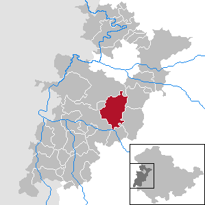
| Location of the municipality of Moorgrund in the Wartburg district | ||
  |
||

Moorgrund is a municipality in the Wartburg district in Thuringia . The unified community stretches from the Rennsteig near Ruhla to the Werraniederung directly in front of the gates of the district town of Bad Salzungen .
geography
Originally the moorland formed an extensive wetland area - in the eastern part it was a moor , this was finally made usable for agricultural purposes in the 19th century by drainage ditches that were connected to the moor stream and the pipe ditch, with the exception of small remnants. At the edges of the valley there are now also protected regions with limestone grasslands and heather areas. The copper minerals, which were discovered in prehistoric times, attracted miners in the Middle Ages, in a narrow strip from Kupfersuhl to Schweina there are remains of medieval mines in the forests, iron has also been found.
Community structure

The districts of the municipality are:
- Eter winds
- Graefen-Nitzendorf
- Gumpelstadt (seat of the municipal administration)
- Copper chair with Wackenhof
- Möhra ( Martin Luther home town)
- Forest fish
- Witzelroda with Neuendorf
history
The municipality of Moorgrund was created on March 25, 1994 through the merger of the municipalities of Gumpelstadt, Waldfisch and Witzelroda. With the municipality of Möhra, Moorgrund formed the administrative community Moorgrund until November 3, 1994 . On November 4, 1994, Moorgrund, Möhra and Kupfersuhl were combined to form the municipality of Moorgrund. On January 1, 1996, Etterwind was incorporated into Moorgrund.
Population development
Development of the population:
|
|
|
|
- Data source: from 1994 Thuringian State Office for Statistics - values from December 31st
politics
Municipal council
The municipal council of Moorgrund consists of 16 councilors. The local elections on May 26, 2019 led to the following result with a turnout of 67.1% (2014: 53.8%):
| Party / list | Share of votes | +/-% p | Seats |
| CDU | 66.8% | + 10.7 | 11 |
| Citizens' interest group Moorgrund (BIV) | 20.4% | + 9.8 | 5 |
The SPD (2014: 23.6%) did not stand as a candidate in 2019.
mayor
The full-time mayor Hannes Knott (CDU) was elected on March 20, 2016.
Culture and sights
Historically, the place Möhra is to be emphasized, here the ancestors of Martin Luther lived as farmers and miners. The municipal administration, a swimming pool and the Alte Warth nature reserve are located in Gumpelstadt . The place has numerous architectural monuments. The former Kissel hunting lodge of the Meiningen dukes is remarkable , it is located near the Rennsteig. The Pummpälzweg has a touristic importance , it connects the hiking destinations of Moorgrund with the neighboring villages, Eisenach and Bad Salzungen. In the 1960s, the Alte Warth motocross pitch was designed for sporting activities and is now an important nature reserve.
gallery

Eter winds

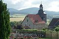
St. George's Church in Gumpelstadt

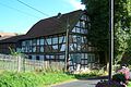
Half-timbered house in Kupfersuhl

Möhra
Church in Witzelroda
The Wackenhof

Draw well, forest fish

Kissel Hunting Lodge

Moor landscape around Graefen-Nitzendorf

NSG "Alte Warth"

Lietebaum near Möhra

"Alter Ringelstein" castle ruins


Individual evidence
- ^ Population of the municipalities from the Thuringian State Office for Statistics ( help on this ).
- ^ Thuringian ordinance on the dissolution and amalgamation of the communities Gumpelstadt, Waldfisch and Witzelroda of February 25, 1994
- ^ Thuringian ordinance on the dissolution and amalgamation of the communities Moorgrund, Möhra and Kupfersuhl of October 7, 1994 Reference: GVBl 1994, p. 1169
- ↑ § 3 Thuringian ordinance on the dissolution of the municipality of Etterimmern and its incorporation into the municipality of Moorgrund and on the dissolution of the administrative community "Eltetal" from September 21, 1995 reference: GVBl 1995, p. 326
- ↑ Local elections in Thuringia on May 26, 2019. Elections of the community and city council members. Preliminary results. The regional returning officer, accessed on June 3, 2019 .
- ↑ News. Municipal administration Moorgrund, accessed on March 21, 2016 .
- ^ Municipal administration (ed.), Leaflet unitary municipality Moorgrund
Web links
Office of Creuzburg | Bad Liebenstein | Bad Salzungen | Barchfeld-Immelborn | Berka vd Hainich | Bischofroda | Buttlar | Dermbach | Empfertshausen | Frankenroda | Geisa | Barley ground | Barley | Hallings | Hörselberg-Hainich | Krauthausen | Krayenberg Community | Lauterbach | Leimbach | Moorgrund | Nazza | Oxen | Ruhla | Schleid | Seebach | Treffurt | Unterbreizbach | Vacha | Weilar | Werra-Suhl Valley | Wiesenthal | Wutha Farnroda