Forest fish
|
Forest fish
Community Moorgrund
Coordinates: 50 ° 51 ′ 29 ″ N , 10 ° 17 ′ 11 ″ E
|
|
|---|---|
| Height : | 305 (300-315) m above sea level NN |
| Residents : | 237 (December 31, 2018) |
| Incorporation : | March 25, 1994 |
| Postal code : | 36433 |
| Area code : | 03695 |
|
Location of forest fish in Moorgrund
|
|
Waldfisch is a district of the municipality Moorgrund in the Wartburg district in Thuringia, which was formed in 1994 as part of an administrative reform . 237 inhabitants currently live in forest fish (as of December 31, 2018).
geography
Geographical location
The district of Waldfisch is located on the southwestern edge of the Thuringian Forest approx. 6 km northeast of the district town of Bad Salzungen .
Neighboring municipalities and towns
Waldfisch borders the town of Ruhla in the northeast and the Schweina district of Bad Liebenstein in the east . In the south, west and north the Moorgrund districts of Gumpelstadt , Möhra , Kupfersuhl and Etterlösungen follow .
mountains
The landscape around forest fish is determined in the northeast by the ridge line of the Thuringian Forest with the Rennsteig and the striking Windsberg ( 670.6 m above sea level ) and in the east by the Alten Warth ( 435.5 m above sea level ).
The highest point in the community is the Hohe Kissel ( 648.6 m above sea level ). Also noteworthy are the mountains and hills Großer Arnsberg ( 647.7 m above sea level ), Rehberg ( 430.2 m above sea level ), Spitzberg ( 363.8 m above sea level ), Heiligenberg ( 363.6 m above sea level) ) and Reckberg ( 338.2 m above sea level ).
Rivers
The place name Waldfisch was once derived from the Fischa brook , which rises on the Kissel and flows south through the Saargrund, receives the Moorbach and flows into the Werra as a right tributary at Barchfeld .
history
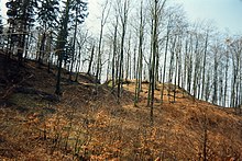
Not far from the Kissel, a Bronze Age barrow field proves the presence of humans in prehistoric times.
First mention
After the Frankenstein burgrave Ludwig, as atonement for his attack on Mühlhausen merchants , promised the Herrenbreitungen monastery a village from his property as early as 1258 , this transfer took place with notarization the following year. The first mention was made on 18 July 1259 as Fischa ... uilla que dictur Uischa domino abbati de wide rabbits ... . Already in 1357 it is clearly called Waltfihzscha .
Place name
The original meaning of the Fischbach place names, which also includes forest fish , indicates that the salmon spawning waters were still important during the settlement phase .
Forest fish in the Middle Ages
Coming from Eisenach, the so-called "Nürnberger Straße" ran close to Waldfisch in the direction of Breitungen and Meiningen. For their control and protection, two high medieval castles were built on the ascent from the Saargrund - they are named Alter Ringelstein and Neuer Ringelstein . In 1316 Gunter von Salza received extensive fiefdoms from the Count of Henneberg , including in Vischa . In 1444, Titzmann von Weberstedt received the villages of Waldfisch, Etterwind, Eckardtshausen and the deserts Taubenellen and Kottern as fiefdoms. Previously, the Thuringian Landgrave Balthasar had already conquered and destroyed Ringelstein Castle, which was disreputed as a robber baron's nest.
The history of forest fish is very closely linked to the history of the neighboring town of Ruhla . The place formed with Gumpelstadt one of the Ruhla "Stabgemeinden", a special medieval legal form, which existed in the Ruhla area until 1897 and granted the communities concerned limited autonomy vis-à-vis the landlords, court lords and sovereigns.
Mining history
By the 10th century at the latest, wandering blacksmiths moved into today's area around Ruhla and Waldfisch in order to mine the iron ore available seasonally. The first sedentary settlers came along the Rennsteig mountain ridge. They were looking for ores to be found above ground and processed them on site as a forest smithy; they were miners, charcoal burners and blacksmiths at the same time.
In the 16th century, copper mining around Kupfersuhl and Schweina led to further mines in the woods near Waldfisch. After the Thirty Years' War the place came to the Duchy of Saxony-Meiningen in 1680 .
Modern times
The important connection to the modern trunk road network took place in 1840 with the construction of a road from Eisenach via Gumpelstadt and Barchfeld to Breitungen, Wasungen and Meiningen . This road became the forerunner of today's Bundesstraße 19 . The district of Meiningen was created during the administrative reform in 1868 . After the abdication of Duke Bernhard III. on November 10, 1918, the Duchy of Meiningen became the Free State of Saxony-Meiningen , which continued until 1920. In 1950 the place was incorporated into the newly created Bad Salzungen district. On March 25, 1994 the communities of Gumpelstadt, Waldfisch and Witzelroda were dissolved and merged to form the new community of Moorgrund.
Around 1920, small workshops and businesses were also set up in Waldfisch as suppliers to the Ruhla industry, but the inhabitants mostly worked as forest workers and farmers.
Population development
In 1955 there were 257 inhabitants.
Development of the population (December 31) :
|
Culture and sights
The village's landmark is the village fountain - an old draw well from the 17th century. The Kissel hunting lodge is the most famous sight, a log cabin-style hunting lodge built around 1870 for the Meiningen dukes on the southwest slope of the Kissel . On the access road to the Kissel you come across a Bronze Age barrow field in the forest. The Kisseleiche, an old trail marker, stands in the direction of Etterwind. The legendary places near the Kissel also include the Brautborn and the deserted ruins of Alter Ringelstein and Neuer Ringelstein . The Pummpälzweg was laid out to promote tourism ; it leads over the Kissel to Eisenach. From the Rennsteig, the Sallmannshäuser Rennsteig branches off at the Ruhla house, a popular hiking trail from Ruhla via Marksuhl to Gerstungen .
The 32.5 hectare nature reserve "Wacholderheide" was designated on April 6, 1995. It is located west of the village of Waldfisch in the direction of the Kupfersuhl.
The striking 250 to 300 year old lime tree at the south-eastern entrance to the village was designated as a natural monument in 1957 .
traffic
Road traffic
The B 19 runs through the village in the Eisenach - Breitungen / Werra - Meiningen section . In 2009 construction began on a bypass, which was opened to traffic on September 1, 2011. From this the state road 1023 branches off , which leads via Möhra, Ettenhausen ad Suhl , Marksuhl to Berka / Werra .
Rail transport
The nearest train stations with stops for the Süd-Thüringen-Bahn are in the district town of Bad Salzungen and in Ettenhausen an der Suhl, five kilometers away .
Economy and tourism
The residents of the Waldfisch community mainly work in the companies in the neighboring district town of Bad Salzungen, in Eisenach and in the surrounding communities. In the village there is a location of the agricultural cooperative Moorgrund, which operates agriculture and animal husbandry according to ecological criteria. The place is also present on the Rennsteig with the popular Hotel-Restaurant Waldhaus Kissel and is therefore a partner in Thuringian Forest Tourism. To expand the tourist offer, the Pummpälzweg was developed, a hiking trail and venue for sports competitions; it leads from Bad Salzungen over the Kissel to Eisenach.
Web links
Individual evidence
- ↑ Forest fish - unitary community Moorgrund. Retrieved January 16, 2019 .
- ↑ a b Thuringian Land Survey Office Wartburgkreis and District Free City of Eisenach , Erfurt 2002, ISBN 3-86140-250-5 .
- ↑ a b Thuringian Land Survey Office TK25 - sheet 5127 Bad Salzungen, Erfurt 1997, ISBN 3-86140-063-4 .
- ↑ a b c Otto Hartmann forest fish ... In: Altensteiner Blätter. Yearbook 1992, p. 63 ff.
- ↑ Waldemar Küther document book of the Frauensee monastery 1202 - 1540. Cologne-Graz 1961. No. 46.
- ^ Edward Schröder Vacha and Fischbach. Salmon migration and settlement on German rivers. In Namn och Bygd magazine for Nordic place-name research. Lund 1928, pp. 39-58.
- ↑ Horst H. Müller Thuringian Forest - A travel guide. tourist-Verlag Berlin and Leipzig 1988, p. 400.
- ^ Thuringian ordinance on the dissolution and amalgamation of the communities Gumpelstadt, Waldfisch and Witzelroda of February 25, 1994
- ^ Paul Luther: Materials for local history lessons - Bad Salzungen district, Suhl district . Ed .: Council of the Bad Salzungen District, Department of Public Education. Bad Salzungen 1959, structure of the district of Suhl (overview of the places and population of the districts), p. 5-11 .
- ^ Website of the municipality of Moorgrund , accessed on September 28, 2015
- ^ Klaus Schmidt: The Wartburg district. Nature and landscape . In: Wartburgkreis (Ed.): Nature conservation in the Wartburgkreis . tape 7 . Printing and publishing house Frisch, Eisenach and Bad Salzungen 1999, p. 87 .
- ^ Biedermann: Natural monuments in the Wartburg district; District Office Wartburgkreis, 2014, page 51


