Eter winds
|
Eter winds
Community Moorgrund
Coordinates: 50 ° 53 ′ 41 ″ N , 10 ° 17 ′ 50 ″ E
|
|
|---|---|
| Height : | 370 (355-390) m |
| Area : | 9.11 km² |
| Residents : | 595 (December 31, 2018) |
| Population density : | 65 inhabitants / km² |
| Incorporation : | January 1, 1996 |
| Postal code : | 36433 |
| Area code : | 036929 |
|
Eter winds
|
|
|
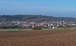
Etterwind seen from the southeast
|
|
Etterzüge is a district of the municipality of Moorgrund in the Wartburg district in Thuringia . The place has 595 inhabitants (as of December 31, 2018).
geography
Geographical location
Etterzüge is located on the southern edge of the western Thuringian Forest in the Thuringian Forest Nature Park . The place is about ten kilometers south of Eisenach , on the upper reaches of the Elte river , a right tributary of the Werra . The Rennsteig runs east of the village , south of the Sallmannshäuser Rennsteig . Surrounded by the forest, the place is in a kind of clearing island . The place is located on the eastern slope of the Eichberg ( 453.9 m above sea level ). The Eisenberg ( 469.6 m above sea level ), about 800 m east of the town with a quarry, is of economic importance . The total area of the district is 9.11 km².
Neighboring municipalities and towns
The place has belonged to the municipality of Moorgrund since a regional reform and borders in the south on the districts of Waldfisch and Möhra , in the west on the district of Kupfersuhl , in the northwest and north on the Eckardtshausen district ( Gerstungen municipality ) and in the east along the Rennsteig on the city of Ruhla .
history
A first documentary mention as a Sterwinde is from 1242.
According to older local research, the town of Etter winds originated as a settlement of deported Slavic prisoners of war in the time of Eastern Franconia . This has now been refuted by research results. Accordingly, the place originated in the 8th century, the place name means: "fenced forest meadow / pasture".
In the High Middle Ages there was also a place called “Schönewinden” and other settlements on the upper reaches of the Elte. All these settlements were given up after wars and epidemics and the present village was created at the farm (?) Etterwind (founding legend).
The inhabitants lived in the territory of the Frankensteiner until 1330 . They made their living from agriculture or worked as woodcutters, blacksmiths and charcoal burners in the Ruhla forests. Iron ore was discovered on the Eisenberg near Etterwinds and there was mining and quarrying there until the 20th century. The top mill of the Elte Valley was located near the former village of Taubenellen . Etterzüge belonged to various nobles, most recently to the Lords of Reckerodt , who in 1523 sold to the Wartburg bailiff for 400 guilders.
To the south of the village, two castles were built in the forest near Nürnberger Straße as early as the 12th century - the Alte Ringelstein below the Kissel hunting lodge and the Neue Ringelstein in the Waldfisch district. Far from the neighboring villages, these castles were primarily used as road posts and customs posts. The border between the later duchies of Saxony-Eisenach and Saxony-Meiningen ran south of Etterwind for several centuries . The old Ringelstein found its way into the legendary world of Thuringia as a robbery castle (legend of the Brautborn).
The Eisenach forests must have been productive for hunting because hunting camps were set up here quite often. The Wartburg bailiff had a special hunting lodge built in nearby Wintershausen in 1524/25 at his own expense. Bear hunts were popular, and in 1537 an Etterwinder driver was injured and he was awarded grain compensation. Around the village, numerous boundary stones mark the village area and at the same time the extent of the ducal hunting grounds.
In the 16th century, copper mining in the area around Kupfersuhl and Möhra reached its peak, remnants of the former pits, ponds and moats can still be found around the Wackenhof and on the road to Kupfersuhl in the Flachsland . During this time, the neighboring towns were involved in haulage services and in the construction of roads and buildings, as evidenced by the mining documents from this period. The church in the town center was built in 1569 as a branch church of Eckardtshausen. The few inhabitants of the village were financially unable to repair the building after the Thirty Years War. In 1817 the church building, which was further damaged by storms and war, was classified as very poor and dilapidated. The ruin was removed in 1842; The evangelical pastor Scheidel from Eckardtshausen immediately submitted plans for a new building, the structural work was already completed on September 24, 1843 with the installation of the weather vane and church tower button, the inauguration took place on July 14, 1844. The simple architectural style of the village church also corresponds interior still preserved.
In the neighboring town of Ruhla, numerous manufacturing operations were established after 1850, in which the Etterwind population found work. To do this, the route had to be covered twice a day (initially on foot) via the Rennsteig on Gollertstrasse.
As a rule, agriculture could only be pursued as a sideline because of the harsh climate and poor crumb . Only the industrial boom in Ruhla created the basis for population growth at the end of the 19th century. Etterzüge has been part of the immediate vicinity of the Wartburg since the Middle Ages, which is ultimately why it was in the Eisenach district as its highest village community. The border location had the consequence that the dialect stands out significantly from the Werra area and also to the nearest place in the moorland, forest fish. The many inhabitants active in the industry of the Erbstromtal were the reason for the membership in the community association of Ruhla (Ruhla, Thal, Kittelsthal, Seebach) which existed during the GDR era. To this day, Etterwind belongs to the area code "036929" (Ruhla). After reunification, the town oriented itself towards Oberellen. Member communities of the now established Eltetal administrative community were the places Eckardtshausen , Etterwind, Förtha , Oberellen , Unterellen and Wolfsburg-Unkeroda . On the occasion of the Thuringian district reform, Etterwind was incorporated into Moorgrund on January 1, 1996. Since then, the postal code 36433 has also been identical to Bad Salzungen. Today, due to the accessibility with public transport, the primary employment of the residents in and near Eisenach and above all the historical affiliation, it is advisable to move closer to Eisenach for the upcoming regional reform.
The oldest traditional association of the place is the "Mixed Folk Choir Etterwind", it was founded in 1883. In addition to the football club and the volunteer fire brigade, the "Etterwindener Carnevalsclub" was also created during the GDR era. The local shooting club was not established until after 1990. The hunting association with its hunting horn blowers is also one of the traditional associations in Etterlösungen. A kindergarten, the village community center, the rooms of the Protestant parish and a children's playground are among the "top addresses" in town.
In the course of the village renewal from 2012 to 2017, extensive renovation measures such as the redesign of the village square and the renovation of the old municipal administration were carried out and a large part of the road network (Triftstraße, Am Friedhof, Kupfersuhler Straße, Schulstraße, Unterm Eichenberg) including supply lines were fundamentally expanded and suitable for the village .
Population development
Development of the population (December 31) :
|
Attractions
- the Protestant church of Etter winds is in the center of the village.
- the townscape of Etterwind is still characterized by half-timbered houses.
- A historical boundary stone is located on the Sallmannshäuser Rennsteig at its intersection with the federal road 19 (about 1.5 km south of the town)
- the camp house is a forester's house near the Taubeneller mill. The building, which was initially used as the guest house of the State Forestry Company, was also used as a location for a DFF crime film from the series: The Public Prosecutor used the word, Episode 100, Hubertus Hunt from 1985 with Rolf Hoppe in the role of a forester.
- The Mörsche Kuppe is a stage on the Sallmannshausen Rennsteig and offers two viewpoints - to the north into the Elte valley and to the south into the moorland.
- Sessile oak with a chest height of 6.28 m (2014).
traffic
The nearest junction ( Eisenach Ost ) of the A4 is fourteen kilometers away. The B 19 runs through the village in the Eisenach - Breitungen / Werra - Meiningen section . From here the road 1126 branches off to Ruhla. The nearest train stations are in Eisenach and in the district town of Bad Salzungen . In Ettenhausen / Suhl, seven kilometers away, there is a stop on the Süd-Thüringen-Bahn .
people
- Otto Ludwig Rudolf Staudt (1870–?), Forester in Dermbach ; Initiator of the first nature reserve in Thuringia (1938, Ibengarten Forest ).
- The Thuringian wood sculptor Ralf Täfler , born in 1955, comes from Etterwinds.He lives and works today in Glücksbrunn Castle in the neighboring town of Schweina .
Web links
Individual evidence
- ↑ https://www.moorgrund.de/gemeindeportraet/etterlösungen//
- ↑ UB Deutschordensballei Thuringia 1 No. 530 (S 453): 1292 Etterwinde; 1349 earthen winds. (Etter - wattle fence around the village)
- ↑ Volker Schimpf: The Heden places in Thuringia. P. 30, note 43. Online (PDF; 3.5 MB)
- ↑ Jürgen Udolph: onenological studies on the German problem. Berlin - New York. P. 277f.
- ^ C. Kronfeld: Regional studies of the Grand Duchy of Saxony-Weimar-Eisenach. Second part. Weimar 1879. p. 44.
- ↑ Erich Debes: The Wartburg Office in the first third of the 16th century. Eisenach 1926. p. 74.
- ^ Siegfried Wünscher The history of copper slate mining and its metallurgy in the Principality of Eisenach. Eisenach 1932.
- ↑ a b Christel Golchert: 703 years Etterhaben . In: MFB Verlagsgesellschaft mbH Eisenach (ed.): StadtZeit. City journal with information from the Wartburg district. July issue. Druck- und Verlagshaus Frisch, Eisenach 1995, p. 26-31 .
- ↑ Federal Statistical Office (Ed.): Municipalities 1994 and their changes since 01.01.1948 in the new federal states. Metzler-Poeschel publishing house, Stuttgart 1995, ISBN 3-8246-0321-7 .
- ↑ https://www.moorgrund.de/gemeindeportraet/etterlösungen/
- ↑ Etterwind - unit municipality Moorgrund. Retrieved January 16, 2019 .
- ^ Entry in the directory of monumental oaks . Retrieved January 10, 2017
- ↑ NN (Fritz Rollberg): The first nature reserve in Thuringia. Ordinance on the Ibengarten nature reserve in the Dermbach Forest, Eisenach district . In: Reinhold Vesper (Hrsg.): Thüringer Heimatschutz, supplement to the Thüringer Fähnlein . Monthly magazine for the Central German homeland . 1938, issue 4. G. Neuenhahn, Jena 1938, p. 25-26 .


