Dietlas
|
Dietlas
Municipality of Krayenberg municipality
|
|
|---|---|
| Coordinates: 50 ° 48 ′ 55 ″ N , 10 ° 5 ′ 21 ″ E | |
| Height : | 258 m above sea level NN |
| Residents : | 550 |
| Incorporation : | June 30, 1994 |
| Incorporated into: | Dorndorf |
| Postal code : | 36460 |
| Area code : | 036963 |
|
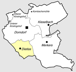
Location of Dietlas in Krayenberggemeinde
|
|
Dietlas is part of the Krayenberg community in the Wartburg district in Thuringia .
location
Dietlas is located south of Dorndorf on the edge of the Thuringian Rhön in the Felda valley . Originally located on the left bank of the Felda, the place has expanded on both sides of the Felda in the course of industrialization. Dietlas is located on Landesstraße 1022, which connects to Bundesstraße 62 and Bundesstraße 84 in Dorndorf . The geographic height of the place is 350 m above sea level. NN .
history
The village was first mentioned on August 10, 1330. At the site of today's castle Feldeck in Dietlas of Felda was one on the left bank Wasserburg . It belonged to Frankenstein's . In 1330 it became a fief of the Counts of Henneberg and was later given to the Ernestines . The place later belonged as an exclave to the office of Salzungen in the Duchy of Saxony-Meiningen .
The people in the surrounding villages used to be poor. The situation only got better when potash pits were built in the region from 1898 onwards . In 1905 a shaft was put into operation in Dietlas, which had already stopped production in the 1920s. The place preserved its agricultural character, it was not until the 1960s that new factory buildings were built on the outskirts through development programs of the GDR government, and the state-owned company Bergwerksmaschinen Dietlas was established. Here, equipment and mining machines that were sold around the world were manufactured for the GDR potash industry's own needs (for the Kali combine ). The plant had a siding on the Feldabahn , opened in 1879 , which was shut down in 2003.
The then mayor Krug reported on the first ten years after the Second World War in a textbook that was used in the Bad Salzungen district for local history lessons: The population has increased from 500 to 850. There is a LPG type I in the village, the land reform was carried out in favor of the poor farmers. The former estate has been divided. The VEB Bergwerksmaschinenbau Dietlas is located on the outskirts, next to which there are three apartment blocks with a total of 16 new apartments for miners. There is now a youth home in the castle and the place has a kindergarten. The citizens are building an elevated tank for the drinking water supply in the national structure .
In 1994 Dietlas was merged with Dorndorf to form the municipality of Dorndorf and has been a district of Dorndorf ever since. In 2013, after Dorndorf's merger with Merkers-Kieselbach , the place became part of the Krayenberg community .
coat of arms
Divided by blue over gold; above two silver buildings, which are connected by a silver wall with a gate opening, below a green leafy tree with a brown trunk on a green disc. The building symbolizes Feldeck Castle. The wooded area and the valley location are represented by the tree. The coat of arms was approved in 1991.
Attractions
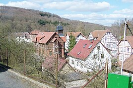
Feldeck Castle , a former moated castle , is located in Dietlas . The castle was freely owned by the Frankensteiners and was sold to the Counts of Henneberg-Schleusingen in 1330. After a renovation in the early 1950s, the residential buildings of the castle were set up as a children's home and sanatorium. With the turnaround , the health resort in Dietlas was discontinued; the castle is again in private ownership and was acquired by the descendants of the previous owners.
Personalities
- Adam Wolfram (1902–1998), politician, was born in Dietlas
- Hans Meyer (* 1942), soccer player and coach, started playing soccer in Dietlas
Web links
Individual evidence
- ↑ Official topographic maps of Thuringia 1: 10,000. Wartburgkreis, district of Gotha, district-free city of Eisenach . In: Thuringian Land Survey Office (Hrsg.): CD-ROM series Top10 . CD 2. Erfurt 1999.
- ^ Wolfgang Kahl : First mention of Thuringian towns and villages. A manual. Verlag Rockstuhl, Bad Langensalza 2010, ISBN 978-3-86777-202-0 , p. 54.
- ↑ Michael Köhler: Thuringian castles and fortified prehistoric and early historical living spaces. Jenzig-Verlag, 2001, ISBN 3-910141-43-9 , p. 100.
- ↑ Dietlas on the official website of the municipality of Dorndorf.Retrieved on June 29, 2012
- ^ Council of the district of Bad Salzungen, Dept. of public education (ed.): Materials for local history lessons - district of Bad Salzungen, district of Suhl . Bad Salzungen 1959, Dietlas - Ten years of socialist land reform. Ten Years of Success in Agriculture, p. 60-62 .
- ^ Thuringian ordinance on the dissolution and amalgamation of the communities Dietlas and Dorndorf of March 17, 1994 (GVBl. P. 387)
- ^ Main statute of the Dorndorf community
- ↑ Hartmut Uelle: Thuringian Wappenbuch . Ed .: Arbeitsgemeinschaft Genealogie eV Printing and Publishing House, Erfurt 1994, p. 96 .


